Maps of Styria
Charte von Herzogthum Steyermark
1 : 850000 Rakousko
Karte von Herzogthum Steyermark
1 : 840000 Štýrsko (Rakousko) Tranquillo Mollo
Karte von Herzogthum Steyermark
1 : 860000 Štýrsko (Rakousko) Florian Mollo
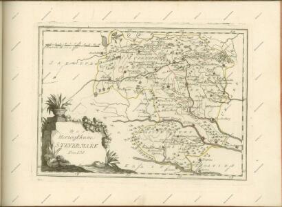
Herzogthum Steyermark
Štýrsko (Rakousko)
Landschaften Innerösterreichs
Innerösterreich Historische Landeskunde
Vollstaendige Post-Karte des Herzogthums Steuermarks
Charte vom Herzogthum Steyermark
1 : 870000 Štýrsko (Rakousko)
Charte vom Herzogthum Steyermark
1 : 870000 Štýrsko (Rakousko)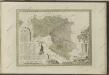

Die Provinz Inner-OEsterreich oder die Herzogthümer Steyermark, Kaernten und Krain, die Grafschaften Goerz und Gradisca und das deutsch-oesterreichische Litorale
1 : 740000 Gorice a Gradiška Kindermann, Joseph Karl Junker, Christoph Franz Xaver Miller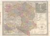
General Post und Strassen Karte des Herzogthums Steiermark
1 : 400000 Mariazell (Rakousko) Schulz, R. A. Peucker, Karl Artaria
Das Königreiche Illyrien und das Herzogthum Steyermark
1 : 700000 Ilýrie Weiland, Karl Ferdinand Anson im Verlage des geographischen Instituts
Das Königreiche Illyrien und das Herzogthum Steyermark
1 : 700000 Ilýrie Weiland, Karl Ferdinand Anson im Verlage des geographischen Instituts
Charte von dem Königreiche Illyrien und dem Herzogthume Steyermark
1 : 690000 Ilýrie Weiland, Karl Ferdinand Bürck, A. im Verlage des Geograph. Instituts
Charte von dem Königreiche Illyrien und dem Herzogthume Steyermark
1 : 690700 Ilýrie Weiland, Karl Ferdinand Bürek, A. im Verlage des Geograph. Instituts
[Štýrsko]
1 : 600000 Štýrsko (Rakousko) Anker
Strassen-Karte des Herzogthums Steyermark
1 : 435000 Štýrsko (Rakousko)
Ducatus Stiriae novissima tabula
1 : 490000 Rakousko Homann, Johann Baptist Vischer, Georg Matthaeus J. B. Homann
Carte du royaume d'Illirie et du duché de Styrie
1 : 520000 Ilýrie Raffelsperger, Franz Rumpold, F. au Dépôt des cartes typografiées
Karte von Inner-Österreich, das ist des Königreiches Illirien und des Herzogthumes Steiermark
1 : 880000 Ilýrie Raffelsperger, Franz Rumpold, F. im Typographischen Landkarten-Verlage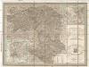
Post und Strassen Karte des Herzogthums Steyermark
1 : 380000 Mariazell (Rakousko) Schulz, R. A. Biller, Dominik Artaria & Comp.
General Post und Strassen Karte des Herzogthums Steyermark
1 : 380000 Mariazell (Rakousko) Schulz, R. A. Artaria & Comp.

Charte von Steyermark
Štýrsko (Rakousko) Kindermann, Joseph Karl Müller, Franz im Verlage des Kunst- und Industrie- Comptoirs
Charte von Steyermark
Štýrsko (Rakousko) Kindermann, Joseph Karl Müller, Franz im Verlage des Kunst- und Industrie-Comptoirs
Charte von Steyermark
Štýrsko (Rakousko) Kindermann, Joseph Karl Müller, Franz im Verlage des Kunst- und Industrie- Comptoirs
General-Karte des Herzogthums Steyermark
1 : 288000 Slovinsko
St. Lucia und die Luzien-Percht am Südostrande der Alpen
Österreich, Slowenien, Volkskunde Umschaden, Kurt ; Neunteufl, Walter