Maps of Valparaíso

[143][146] Novae Hispaniae, Chili, Peruviae, et Guatimalae Littorae, uit: Atlas sive Descriptio terrarum orbis
Annotatie: Gedigitaliseerde versie. Amsterdam. Heiloo : Picturae (vervaardiger), 2015. tiff-bestand. Gedigitaliseerd: 07-01-2015; Origineel: Universiteitsbibliotheek Vrije Universiteit (XL.05127.-) ; Netherlands; Titelpagina ontbreekt Wit, Frederik de Amsterdam : Frederick de Wit
Novæ Hispaniæ, Chili, Peruviæ, et Guatimalæ littoræ
1 Karte : Kupferdruck ; 47 x 56 cm Renard apud L. Renard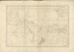
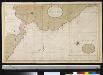
Een gedeelte van de Zuijd-Zee vertoonde de kust van Peru en een gedeelte van Nova Hispania van Arica tot G. de Papagallio na de France afteekening
South-America Gerard van Keulen
Peru
from America: being the latest, and most accurate description of the Nevv vvorld; containing the original of the inhabitants, and the remarkable voyages thither. The conquest of the vast empires of Mexico and Peru, and other large provinces and territories, with the several European plantations in those parts. Also their cities, fortresses, towns, temples, mountains, and rivers. Their habits, customs, manners, and religions. Their plants, beasts, birds, and serpents. With an appendix, containing, besides several other considerable additions, a brief survey of what hath been discover'd of the vnknown south-land and the Arctick region. Collected from most authentick authors, augmented with later observations, and adorn'd with maps and sculptures, by John Ogilby ...
Peruviae Auriferae Regionis Typus. [Karte], in: Theatrum orbis terrarum, S. 73.
1 Karte aus Atlas Ortelius, Abraham Vrients, Jan Baptista
Sud-America I.
1 : 13000000 Berghaus, Heinrich; Flemming, Carl; Handtke, Friedrich H.; Sohr, Karl
Peru [Karte], in: Novus atlas absolutissimus, Bd. 6, S. 234.
1 Karte aus Atlas Janssonius Offizin
Colombia, Ecuador, Peru, Panama.
1 : 5274720 Stanford, Edward
Mappa geographica Americae Septentrionalis : ad emendatiora exemplaria adhuc edita jussu Acad. reg. scient. et eleg. litt. descripta.
from Charts and maps
Peru [Karte], in: Novus Atlas, das ist, Weltbeschreibung, Bd. 2, S. 355.
1 Karte aus Atlas Blaeu, Joan Blaeu, Willem Janszoon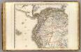
Amerique Meridionale 1.
1 : 6400000 Brue, Adrien Hubert, 1786-1832
Mittel America.
1 : 16500000 Reichard, C. G.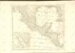

153-54. America Centrale, Colombia, Ecuador, Peru, Venezuela.
1 : 10000000 Touring club italiano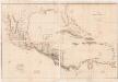
Chart of the West Indies and Spanish Dominions in North America
1 : 2775525 Arrowsmith, Aaron, 1750-1823 Published June 1st, 1803, by A. Arrowsmith, No. 24 Rathbone Place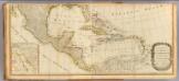
(North America south)
1 : 5400000 Kino, Eusebio Francisco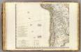
Amerique Meridionale 3.
1 : 6400000 Brue, Adrien Hubert, 1786-1832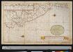
Nieuwe afteekening van de cust van Peru met alle desselfs geleegentheeden is geleegen in de Zuijtzee
Peru Gerard van Keulen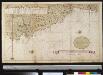
Nieuwe afteekening van de cust van Peru met alle desselfs geleegentheeden is geleegen in dZuyt Zee
Peru Gerard van Keulen
Bolivia, Ecuador, Peru.
1 : 6700000 Rand McNally and Company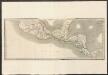
Mexico and Guatemala
A new general atlas of modern geography, consisting of a complete collection of maps of the four quarters of the globe Wyld, James James Wyld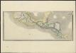
Mexico and Guatemala, shewing the position of the mines
1 : 4500000 London : Jas. Wyld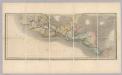
Mexico and Guatemala.
1 : 4200000 Wyld, James, 1812-1887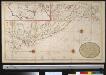
Nieuwe afteekening van Peru met alle desselfs gelegentheden zijnde geleegen in de Groote Zuijt Zee
Peru Gerard van Keulen
Peru [Karte], in: Gerardi Mercatoris et I. Hondii Newer Atlas, oder, Grosses Weltbuch, Bd. 2, S. 410.
1 Karte aus Atlas Mercator, Gerhard und Hondius, Jodocus Jansson, Jan
Peru [Karte], in: Theatrum orbis terrarum, sive, Atlas novus, Bd. 2, S. 365.
1 Karte aus Atlas Blaeu, Joan Blaeu, Willem Janszoon
Peru [Karte], in: Le théâtre du monde, ou, Nouvel atlas contenant les chartes et descriptions de tous les païs de la terre, Bd. 2, S. 350.
1 Karte aus Atlas Blaeu, Willem Janszoon und Blaeu, Joan Blaeu, Willem Janszoon
Terra Firma et Novum Regnum Granatense et Popayan
from America: being the latest, and most accurate description of the Nevv vvorld; containing the original of the inhabitants, and the remarkable voyages thither. The conquest of the vast empires of Mexico and Peru, and other large provinces and territories, with the several European plantations in those parts. Also their cities, fortresses, towns, temples, mountains, and rivers. Their habits, customs, manners, and religions. Their plants, beasts, birds, and serpents. With an appendix, containing, besides several other considerable additions, a brief survey of what hath been discover'd of the vnknown south-land and the Arctick region. Collected from most authentick authors, augmented with later observations, and adorn'd with maps and sculptures, by John Ogilby ...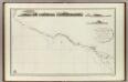
![[143][146] Novae Hispaniae, Chili, Peruviae, et Guatimalae Littorae, uit: Atlas sive Descriptio terrarum orbis](https://images-2.georeferencer.com/images/iiif/014762546629/full/,300/0/native.jpg)

