Maps of Cordillera Oriental

Peruviae Auriferae Regionis Typus. [Karte], in: Theatrum orbis terrarum, S. 73.
1 Karte aus Atlas Ortelius, Abraham Vrients, Jan Baptista
Colombia, Venezuela, Ecuador, Perú y Bolivia
1 mapa. Datat al s. XIX. Gras y compañia, editores. Madrid
Peru and the Amazones, country. (Inset: the Gallapagos Islands.)
from New & accurate description of the earth in all its empires, kingdoms and states
Peru
from America: being the latest, and most accurate description of the Nevv vvorld; containing the original of the inhabitants, and the remarkable voyages thither. The conquest of the vast empires of Mexico and Peru, and other large provinces and territories, with the several European plantations in those parts. Also their cities, fortresses, towns, temples, mountains, and rivers. Their habits, customs, manners, and religions. Their plants, beasts, birds, and serpents. With an appendix, containing, besides several other considerable additions, a brief survey of what hath been discover'd of the vnknown south-land and the Arctick region. Collected from most authentick authors, augmented with later observations, and adorn'd with maps and sculptures, by John Ogilby ...
Sud-America I.
1 : 13000000 Berghaus, Heinrich; Flemming, Carl; Handtke, Friedrich H.; Sohr, Karl
[Carte du Peru]
1 : 195000 Buache, Philippe, 1700-1773 sur le Quay de la Megisserie avec privilege du Roy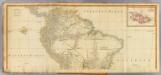
(South America north)
1 : 7900000 Anville, Jean Baptiste Bourguignon d, 1697-1782; Kitchin, Thomas; Robert Laurie & James Whittle
Venezuela, New Granada, Ecuador, Peru & Bolivia Chile And Guiana.
1 : 15206400 Johnson, A.J.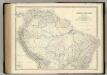
South America N.
1 : 8989200 Johnston, Alexander Keith, 1804-1871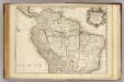
Terre Ferme, Perou, Bresil, Amazones.
1 : 9000000 L'Isle, Guillaume de, 1675-1726
Carte de la Terre Ferme, du Perou, du Bresil et du Pays des Amazones
1 : 9000000
Accurata Utopiæ tabula, Das ist der neu-entdeckten Schalck Welt, oder des so offt benanten, und doch nie erkanten Schlarraffenlandes : neu erfundene lacherliche Land tabell ... / durch Authorem Anonymum
1 : 40000000 titelvariant: Accurata Utopiæ tabula; Annotatie geografische gegevens: 3 schaalstokken: [0] - 1 Schlarraffische grosse Mäuler, [0] - 2 Kleine venerische oder Hoffartige Mäuler, [0] - 300 Teutsche geometrische Meilen [Augsburg : Seutter]
Carte de la terre ferme du Perou, du Bresil et du Pays des Amazones
1 : 9000000 dressée sur les descriptions de Herrera de Laet, et des PP. Acuña, et M. Rodriguez et sur plusieurs relations et observations posterieures par Guillaume del'Isle A Amsteldam : chez Jean Covens et Corneille Mortier, geographes
Süd-America
Hand-Atlas über alle Theile der Erde nach dem neuesten Zustande und über das Weltgebäude Stieler, Adolf bei Justus Perthes
Süd-America in zwei Blättern
Hand-Atlas über alle Theile der Erde nach dem neuesten Zustande und über das Weltgebäude Stieler, Adolf bei Justus Perthes

Colombia, Venezuela, Guiana.
1 : 14000000 Mitchell, Samuel Augustus
Brazil, Bolivia, Paraguay, Uruguay.
1 : 20500000 Mitchell, Samuel Augustus
New Granada, Venezuela, Guiana.
1 : 14000000 Mitchell, Samuel Augustus Jr.
New Granada, Venezuela, Guiana.
1 : 14000000 Mitchell, Samuel Augustus
New Granada, Venezuela, Guiana.
1 : 14000000 Mitchell, Samuel Augustus
Map Of New Granada, Venezuela, And Guiana.
1 : 14000000 Mitchell, Samuel Augustus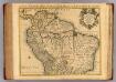
Terre Ferme, Perou, Bresil, et du pays des Amazones.
1 : 9000000 L'Isle, Guillaume de, 1675-1726
Tabula Americae Specialis Geographica Regni Peru, Brasiliae, Terrae Firmae
1 : 9000000 Esta es una adaptación de la empresa Homann Heirs (también es conocida como Homann Erben, o herederos de Homann, en castellano) del mapa Carte de la Terre Ferme, du Perou, du Bresil, et du Pays des Amazones de Guillaume Del'Isle, originalmente publicado en Paris en 1703. La región amazónica aparece como “Terra Amazonum”, un lugar distinto y diferenciable de los territorios vecinos españoles (Tierra Firme, Peru, Paraguay) y portugueses (Brasil). La empresa Homann Heirs fue creada tras la muerte de Johann Baptiste Homann (1664-1724), famoso Geógrafo del Sacro Imperio Romano Germánico. A mediados del siglo XVIII la empresa estaba dirigida por el geógrafo Johann Michael Franz y por el grabador Johann Georg Ebersberg hijastro de Johann Baptiste Homann. La empresa funcionó en Núremberg hasta 1848 produciendo múltiples obras de geografía, atlas y mapas. Homann Erben (Empresa) L'Isle, Guillaume de (1675-1726)
Tabula Americæ specialis geographica regni Peru, Brasiliæ, Terræ Firmæ & reg: Amazonum
1 Karte : Kupferdruck ; 47 x 54 cm L'Isle; Herrera; Rodriguez; Acuña; Laet nunc recusa per Homannianos heredes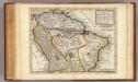
Map of Terra Firma, Peru, Amazone-Land, Brasil &c.
1 : 22000000 Moll, Herman, d. 1732
Süd-America
Handatlas über alle Theile der Erde und über das Weltgebäude Stieler, Adolf Justus Perthes
Der Nördliche Theil von Süd-America enthaltend Columbia, Guyana, Peru, Brasielien und Bolivia
Stieler's Hand-Atlas Stieler, Adolf bei Justus Perthes
General-Charte von Süd America
Brazílie Spix, Johann Baptist von Martius, Carl Friedrich Philipp von
![Peruviae Auriferae Regionis Typus. [Karte], in: Theatrum orbis terrarum, S. 73.](https://images-2.georeferencer.com/images/iiif/169698717707/full/,300/0/native.jpg)

