Maps of Sardegna
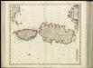
[34][34] Insularum Sardiniae et Corsicae descriptio, uit: Atlas sive Descriptio terrarum orbis
Annotatie: Gedigitaliseerde versie. Amsterdam. Heiloo : Picturae (vervaardiger), 2015. tiff-bestand. Gedigitaliseerd: 07-01-2015; Origineel: Universiteitsbibliotheek Vrije Universiteit (XL.05127.-) ; Netherlands; Titelpagina ontbreekt Wit, Frederik de Amsterdam : Frederick de Wit
Carte Nouvelle de L'Isle Et Royaume De Sardagne. &c. Levée par Ordre Expres à L'Usage des Armées en Italie ou sont Exactement Marquées les Grands-Chemins. &c. [Karte], in: Atlas nouveau, contenant toutes les parties du monde [...], Bd. 2, S. 148.
1 Karte aus Atlas Sanson, Nicolas Jaillot, Alexis Hubert und Mortier, Pieter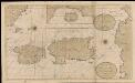
De eijlanden van Corcica en Zardinia met de tegen overcust van Barbaria
France Gerard van Keulen
Die Königreiche Spanien und Portugal nach den neuesten Beobachtungen verfast
Španělsko Votésky, Michael Mollo, Tranquillo Tranquillo Mollo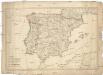
Die Königreiche Spanien und Portugal nach den neuesten Beobachtungen verfasst
Španělsko Renner Kleinknecht T. Mollo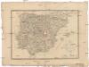
Karte von Spanien und Portugal.
Španělsko Brué, A. H. Rothenburg, R. v. Artaria
Nouvelle carte politique, militaire et routiere de l'Espagne et du Portugal
Španělsko Tramezini, Michaelo Hinrichs, J. C. J.C. Hinrichs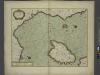
The sea coast of ITALY from cape DelleMelle to Mount Argentato with the Island of CORSICA
from The sea-atlas : containing an hydrographical description of most of the sea-coasts of the known parts of the world.
Kingdom of Sardinia.
1 : 1160000 Tanner, Henry S.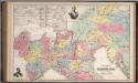
A New Map of Northern Italy by W.H. Holmes.
1 : 1203840 Mitchell, Samuel Augustus
Kingdom of Sardinia
1 : 1164000 Mitchell, Samuel Augustus
Ancient Spain, Portugal.
1 : 3450000 Society for the Diffusion of Useful Knowledge (Great Britain)
Corsica, Sardinia, Belearic Islands, Valetta.
1 : 1750000 Society for the Diffusion of Useful Knowledge (Great Britain)
Carta d'Italia alla scala di 1 a 1 000 000
1 : 1000000 Westblatt Istituto Geografico Militare (Firenze) Istituto Geografico Militare
Weltkarte 1:1 000 000
1 : 1000000 OKH/Gen St d H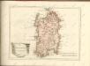

Insularum Sardiniae et Corsicae Descriptio
1 : 1100000 Mollova mapová sbírka Wit, Frederik de Covens, Johannes I
Insulae Sardiniae Nova & accurata Descriptio. [Karte], in: Novus atlas absolutissimus, Bd. 5, S. 108.
1 Karte aus Atlas Janssonius Offizin
Fo. 3, uit: Carta geologica d'Italia
1 : 1000000 Rome : R. Ufficio Geologico
Isles de Corse et de Sardaigne
1 : 1740000 Korsika (Francie) Bonne, Rigobert André
Sardinia. [Karte] , in: Theatrum orbis terrarum, S. 520.
1 Karte aus Atlas Ortelius, Abraham Vrients, Jan Baptista

[Itálie]
1 : 1150000 Achaia (Řecko)
Charte von Corsica und Sardinien
1 : 645000 Korsika (Francie) Stieler, Adolf Azuni Kunsthandlung Adam Gottlieb Schneider und Weigels
Übersichtskarte von Mittel - Europa

Sardinia. [Karte], in: Theatrum orbis terrarum, S. 416.
1 Karte aus Atlas Ortelius, Abraham
Nieuwe Paskaert van de Zee Kusten van Provence en Italiae
1 : 850000 Mollova mapová sbírka Keulen, Gerard van Keulen, Gerard van
Fo. 5, uit: Carta geologica d'Italia
1 : 1000000 Rome : R. Ufficio Geologico
Carta aeronautica d'Italia al 1:1.000.000°
1 : 1000000 Ufficio di Stato maggiore della R. Aeronautica
Civitavecchia, I. Corsica
1 : 750000 Korsika (Francie) Nimmerfroh, J. K. u. k. Militärgeographisches Institut
![[34][34] Insularum Sardiniae et Corsicae descriptio, uit: Atlas sive Descriptio terrarum orbis](https://images-2.georeferencer.com/images/iiif/891639383936/full/,300/0/native.jpg)

