Maps of Sassari

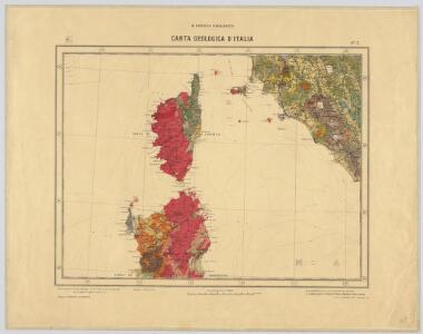
Fo. 3, uit: Carta geologica d'Italia
1 : 1000000 Rome : R. Ufficio Geologico
Carta d'Italia alla scala di 1 a 1 000 000
1 : 1000000 Westblatt Istituto Geografico Militare (Firenze) Istituto Geografico Militare
Weltkarte 1:1 000 000
1 : 1000000 OKH/Gen St d H
Insularum Sardiniae et Corsicae Descriptio
1 : 1100000 Mollova mapová sbírka Wit, Frederik de Covens, Johannes I
Isles de Corse et de Sardaigne
1 : 1740000 Korsika (Francie) Bonne, Rigobert André

Übersichtskarte von Mittel - Europa

Civitavecchia, I. Corsica
1 : 750000 Korsika (Francie) Nimmerfroh, J. K. u. k. Militärgeographisches Institut
Civitavecchia, I. Corsica
1 : 750000 Korsika (Francie) K. k. militär-geographisches Institut
Ancient Spain, Portugal.
1 : 3450000 Society for the Diffusion of Useful Knowledge (Great Britain)
Corsica, Sardinia, Belearic Islands, Valetta.
1 : 1750000 Society for the Diffusion of Useful Knowledge (Great Britain)
Corsica. [Karte], in: Theatrum orbis terrarum, S. 322.
1 Karte aus Atlas Ortelius, Abraham Vrients, Jan Baptista
L'Isle de Corse
1 : 400000 Korsika (Francie) Lotter, Tobias Conrad Lotter, Georg F. par Tobie Conrad Lotter
L'Isle de Corse
1 : 400000 Korsika (Francie) Lotter, Tobias Conrad Lotter, Georg F. par Tobie Conrad Lotter
L'Isle de Corse
1 : 400000 Korsika (Francie) Lotter, Tobias Conrad par Tobie Conrad Lotter
Charte von Corsica und Sardinien
1 : 645000 Korsika (Francie) Stieler, Adolf Azuni Kunsthandlung Adam Gottlieb Schneider und Weigels
Isle de Corse à la Republique de Genes
1 : 880000 Mollova mapová sbírka Sanson, Nicolas Mariette, Pierre

Insulae Corsicae Nova & accurata Descriptio. [Karte], in: Novus atlas absolutissimus, Bd. 5, S. 105.
1 Karte aus Atlas Janssonius Offizin
Corsica. [Karte], in: Theatrum orbis terrarum, S. 416.
1 Karte aus Atlas Ortelius, Abraham
Sheet XVI: Karte Des Oesterreichischen Kaiserstaates.
1 : 576000 Scheda, Josef
Insularum Aliquot Maris Mediterranei Descriptio. [Sardinia und Corsicae Insulae Pars] [Karte], in: Theatrum orbis terrarum, S. 91.
1 Karte aus Atlas Ortelius, Abraham
XVI, uit: General-Karte des oesterreichischen Kaiserstaates mit einem grossen Theile der angrenzenden Länder / durch Josef Scheda ... bearb. und hrsg
1 : 576000 Annotatie geografische gegevens: Maatstokken: oesterreichische Meilen, geografische oder deutsche Meilen, preussische Meilen, türkische Berri, französische Lieues, russische Werste; Maatstok per blad: wiener Klafter, öster. Meilen; Blad XIX: statistische en taalkundige informatie; Blad XIX: legenda [Wien : K.K. Militärisch-Geografisches Institut]
Insularum Aliquot Maris Mediterranei Descriptio. [Sardinia und Corsicae Insulae Pars] [Karte], in: Theatrum orbis terrarum, S. 240.
1 Karte aus Atlas Ortelius, Abraham
Insularum Aliquot Maris Mediterranei Descriptio. [Sardinia und Corsicae Insulae Pars] [Karte], in: Theatrum orbis terrarum, S. 335.
1 Karte aus Atlas Ortelius, Abraham Vrients, Jan Baptista
Sardinia Insula. [Karte], in: Novus Atlas, das ist, Weltbeschreibung, Bd. 3, S. 325.
1 Karte aus Atlas Blaeu, Joan Blaeu, Willem Janszoon
Sardinia. [Karte], in: Theatrum orbis terrarum, S. 416.
1 Karte aus Atlas Ortelius, Abraham
Nouvelle carte de l'isle de Corse : apartenante a la Republique de Genes, presentement divisée & soulevée, sous les ordres du Baron de Neuhoff, elu Roy sous le nom de Theodore Premier
1 : 400000 levé sur les lieux par le capitaine I. Vogt donnée au jour par Renier & Iosue Ottens, geographes a Amsterdam Amsterdam : Renier & Iosue Ottens