Maps of Tuscany

XVI, uit: General-Karte des oesterreichischen Kaiserstaates mit einem grossen Theile der angrenzenden Länder / durch Josef Scheda ... bearb. und hrsg
1 : 576000 Annotatie geografische gegevens: Maatstokken: oesterreichische Meilen, geografische oder deutsche Meilen, preussische Meilen, türkische Berri, französische Lieues, russische Werste; Maatstok per blad: wiener Klafter, öster. Meilen; Blad XIX: statistische en taalkundige informatie; Blad XIX: legenda [Wien : K.K. Militärisch-Geografisches Institut]
Sheet XVI: Karte Des Oesterreichischen Kaiserstaates.
1 : 576000 Scheda, Josef
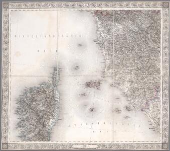
Übersichtskarte von Mittel - Europa

Civitavecchia, I. Corsica
1 : 750000 Korsika (Francie) Nimmerfroh, J. K. u. k. Militärgeographisches Institut
Civitavecchia, I. Corsica
1 : 750000 Korsika (Francie) K. k. militär-geographisches Institut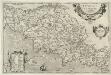
Tvsciae Antiqvae Typvs Ex conatibus geographicis
1 : 760000 Mollova mapová sbírka Ortelius, Abraham Ortelius, Abraham

Italiae orae
1 : 804000 Janov (Itálie : oblast) Barents, Willem
Territorio Di Siena, con il Ducato di Castro. [Karte], in: Novus atlas absolutissimus, Bd. 5, S. 128.
1 Karte aus Atlas Janssonius Offizin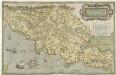
Thvsciae Descriptio
1 : 740000 Mollova mapová sbírka Bellarmati, Girolamo
Thvsciae descriptio
1 Karte : Kupferdruck ; 30 x 48 cm Bell'Armato; Ortelius s.n.
Thvsciae descriptio
1 Karte : Kupferdruck ; 31 x 48 cm Bell'Armato; Ortelius s.n.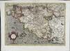
Tvscia
1 Karte : Kupferdruck ; 31 x 45 cm Mercator; Hondius Henricus Hondius
Tvscia
1 Karte : Kupferdruck ; 31 x 44 cm Mercator s.n.
Novissima et Accuratior Tabella Magni Ducatûs Hetruriae
1 : 480000 Mollova mapová sbírka Seutter, Matthäus Lotter, Tobias Conrad Seutter, Matthäus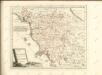

Estat du Grand Duc de Toscane, &c
1 : 690000 Mollova mapová sbírka Covens, Johannes Covens, Johannes I
Nouvelle carte de l'isle de Corse : apartenante a la Republique de Genes, presentement divisée & soulevée, sous les ordres du Baron de Neuhoff, elu Roy sous le nom de Theodore Premier
1 : 400000 levé sur les lieux par le capitaine I. Vogt donnée au jour par Renier & Iosue Ottens, geographes a Amsterdam Amsterdam : Renier & Iosue Ottens
Granducato di Toscana
1 : 520000 Marzolla, Benedetto [Verlag nicht ermittelbar]
Dominio Fiorentino
1 : 620000 Mollova mapová sbírka Magini, Giovanni Antonio Magini, Fabio
Granducato di Toscana.
1 : 520000 Marzolla, Benedetto
Territorio Di Siena et Ducato di Castro [Karte], in: Novus Atlas, das ist, Weltbeschreibung, Bd. 3, S. 234.
1 Karte aus Atlas Blaeu, Joan Blaeu, Willem Janszoon
La Toscana
1 : 1200000 dell'A. B. Borghi [S.l.] : [s.n.]
Nouvelle carte de l'isle de Corse : apartenante a la Republique de Genes, presentement divisée & soulevée, sous les ordres du Baron de Neuhoff, elu Roy sous le nom de Theodore Premier
1 : 400000 levé sur les lieux par le capitaine I. Vogt donnée au jour par Renier & Iosue Ottens, geographes a Amsterdam Amsterdam : Renier & Iosue Ottens
Territorio Di Siena et Ducato di Castro [Karte], in: Le théâtre du monde, ou, Nouvel atlas contenant les chartes et descriptions de tous les païs de la terre, Bd. 3, S. 218.
1 Karte aus Atlas Blaeu, Willem Janszoon und Blaeu, Joan Blaeu, Willem Janszoon
Territorio Di Siena et Ducato di Castro [Karte], in: Theatrum orbis terrarum, sive, Atlas novus, Bd. 3, S. 208.
1 Karte aus Atlas Blaeu, Joan Blaeu, Willem Janszoon
Dominio Fiorentino. [Karte], in: Novus Atlas, das ist, Weltbeschreibung, Bd. 3, S. 221.
1 Karte aus Atlas Blaeu, Joan Blaeu, Willem Janszoon
Dominio Fiorentino. [Karte], in: Theatrum orbis terrarum, sive, Atlas novus, Bd. 3, S. 197.
1 Karte aus Atlas Blaeu, Joan Blaeu, Willem Janszoon
Corse
1 : 320000 Annotatie: Herdruk van originele koperplaat; Oorspr. uitg.: [Paris] : Dépôt de la Guerre, 1886 [Paris : IGN]