Maps of China
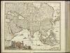
[4][4] Accuratissima totius Asiae tabula, uit: Atlas sive Descriptio terrarum orbis
Annotatie: Gedigitaliseerde versie. Amsterdam. Heiloo : Picturae (vervaardiger), 2015. tiff-bestand. Gedigitaliseerd: 07-01-2015; Origineel: Universiteitsbibliotheek Vrije Universiteit (XL.05127.-) ; Netherlands; Titelpagina ontbreekt Wit, Frederik de Amsterdam : Frederick de Wit
Asia accuratissime descripta
1 : 19000000 ex omnibus, quae hactenus extiterunt, imprimis viri ampliss. Nicolai Witsen, consulis Amstelaedamensis exactissimis delineatiobus Amst. : P. Schenk ex

Asiae Nova Descriptio. [Karte], in: Theatrum orbis terrarum, S. 55.
1 Karte aus Atlas Ortelius, Abraham Vrients, Jan Baptista
Neueste Karte von Asien
Grosser Hand-Atlas über alle Theile der Erde in 170 Karten Meyer, J. Verlag des Bibliographischen Instituts
L'Asie / par N. Sanson, geographe ord.re du roy
1 : 22000000 1 Karte : Kupferdruck ; 40 x 55 cm Sanson, Guillaume chez l'autheur au galleries du Louvre
Asiae recens summa cura delineata [Karte], in: Gerardi Mercatoris et I. Hondii Newer Atlas, oder, Grosses Weltbuch, Bd. 1, S. 36.
1 Karte aus Atlas Mercator, Gerhard und Hondius, Jodocus Jansson, Jan
Asia / correcta et adornata per Matthaeum Seutter, S. C. M. Geogr. ; A.C. Seutter delin. ; Tob. Conr
1 : 41000000 1 Karte : Kupferdruck ; Seutter, Albrecht Carl anjezo in Verlag bey Tobias Conrad Lotter, Geogr. in Ausgburg
Asien
1 : 21600000 entworfen und gezeichnet von C.F. Weiland Weimar : im Verlage des Geograph. Instituts
[Kaart], uit: Asien : politisch-wirtschaftlich
1 : 12000000 Bern : Kümmerly & Frey
Nieuwe kaart van Asia volgens de laatste ontdekkingen
1 : 60000000 [S.l.] : [s.n.]
Asia recens summa cura delineata [Karte], in: Novus atlas absolutissimus, Bd. 6, S. 85.
1 Karte aus Atlas Janssonius Offizin
[Asie]
Asie Probst, Johann Balthasar Johan[n] Michael Probst
L'Asie.
1 : 43000000 L'Isle, Guillaume de, 1675-1726
Generalis totius Imperii Moscovitici : novissima tabula magnam orbis terrarum partem a Polo Arctico usq[ue] ad mare Iaponicum, et Chine septentrionalis confinia exhibens cum via Czaricae nuper legationis ex urbe Moscua per universam Tartariam ad magnu[m] Chinae Imperatorem
1 : 13000000 Homann, Johann Baptist, 1663-1724 [I.B. Homann]
L'Asie, suivant les nouvelles observations de Messrs. de l'Académie Royale des Sciences etc., augmentées de nouveau
1 : 37000000 A Leide : chez Pierre vander Aa
Accuratissima totius Asiae tabula in omnes partes divisa
1 : 25330000 de novo correcta, ac in lucem edita per Fredericum de Witt Amstelodami : ex officina J. Cóvens et C. Mortier
Asien
1 : 20550000 entworfen und gezeichnet von C. F. Weiland gest. v. C. J. Mädel sen. Weimar : Verlag des Geograph. Instituts
[Historisch-geographischer Atlas zu den allgemeinen Geschichtswerken von C. v. Rotteck, Pölitz u. Becker] : Asien zur Uebersicht des neuesten Zustandes und der wichtigsten geographische Entdeckungen
von Julius Loewenberg [Freiburg im Breisgau] : [Herder]
Asia [...] [Karte], in: Atlas, sive, Cosmographicae meditationes de fabrica mundi et fabricati figura, S. 71.
1 Karte aus Atlas Mercator, Gerhard
Asia Antiqua cum finitimis Africae et Europae Regionibus. [Karte], in: Novus atlas absolutissimus, Bd. 10, S. 27.
1 Karte aus Atlas Janssonius Offizin
Exactissima Asiae delineatio
1 : 22000000 1 Karte : Kupferdruck ; 48 x 56 cm Danckerts,Theodorus [Danckerts]
ASIA | noviter delineata
Auctore | Guiljelmo Blaeuw [Amsterdam : Joan Blaeu]
Asien
Volksschul-Atlas über alle Teile der Erde Lange, Henry Druck und Verlag von Georg Westermann
L'Asie
1 : 23380000 Asie Sanson, Guillaume Cordier, Louis chez H. Iaillot

[Historisch-geographischer Atlas zu den allgemeinen Geschichtswerken von C. v. Rotteck, Pölitz u. Becker] : Erdansichten zur Uebersicht der wichtigsten geograpischen Systeme des Alterthums
von Julius Loewenberg [Freiburg im Breisgau] : [Herder]
Asia [Karte], in: Gerardi Mercatoris Atlas, sive, Cosmographicae meditationes de fabrica mundi et fabricati figura, S. 70.
1 Karte aus Atlas Mercator, Gerhard Montanus, Petrus
Asia noviter delineata [Karte], in: Novus Atlas, das ist, Weltbeschreibung, Bd. 2, S. 260.
1 Karte aus Atlas Blaeu, Joan Blaeu, Willem Janszoon
![[4][4] Accuratissima totius Asiae tabula, uit: Atlas sive Descriptio terrarum orbis](https://images-2.georeferencer.com/images/iiif/646743100626/full/,300/0/native.jpg)

