Maps of Poland

Kleine geologische Karte von Deutschland / bearb. von W. Schriel ; hrsg. von der Preussischen Geologischen Landesanstalt
1 : 2000000 Annotatie: Bijbehorend materiaal (Erläuterungen. - Ibid., 1930. - 28 p. : ill. ; 21 cm + krt) apart opgeborgen in legendakast Schriel, Walter; Preussische Geologische Landesanstalt Berlin : Preussische Geologische Landesanstalt
Germaniae Antiqvae Popvli
1 : 10750000 Mollova mapová sbírka Clüver, Philipp Fuhrmann, Mathias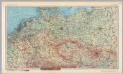
Central Europe. Pergamon World Atlas.
1 : 2500000 Polish Army Topography Service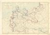
Karte der deutschen Wasser Wasserstrassen
Neueste Post-Karte von Deutschland und den angrenzenden Laendern
1 : 1700000 Maďarsko Mollo, Tranquillo T. Mollo
Prussia - Holland and the German States.
1 : 3380000 Sharpe, J.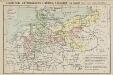
Geschichtl. Entwicklung d. Königr. Preussen vom Frieden von Tilsit (1807) bis jetzt
Deutschland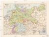
Německá říše
1 : 3250000 Evropa střední Státní nakladatelství
Neueste Post Karte von ganz Deutschland
1 : 1460000 Evropa střední Müller, Franz Artaria
L'Allemagne 843 a 911.
1 : 6300000 Houze, Antoine Philippe
Germania magna, Rhaetia, Noricum
1 : 3800000 Evropa střední Spruner, Karl von Behrens, W. Justus Perthes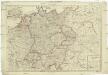
Deutschland nach seiner neuesten Grenz-Berichtigung
1 : 2350000 Evropa střední Mollo, Tranquillo T. Mollo
Deutschland nach seiner neuesten Grenz-berichtigung
1 : 2350000 Evropa střední Mollo, Tranquillo T. Mollo
Deutschland nach seiner neuesten Grenz-Berichtigung
1 : 2370000 Evropa střední Mollo, Tranquillo bey T. Mollo
La Germanie 741 a 843.
1 : 6300000 Houze, Antoine Philippe
Das Sprachgebiet der Deutschen in Mitteleuropa
1 : 7500000 Mitteleuropa Deutsche, Sprachkartografie
Mapa teatru wojny na morzu i na lądzie
1 : 3000000 Belgie Scheda, Joseph von Steinhauser, Anton Artaria
Nova Germaniae Descriptio
1 : 3100000 Mollova mapová sbírka Janssonius, Johannes Janssonius, Johannes I
Neueste Post Karte von Deutschland und dessen angrenzenden Länder
Evropa střední Jättnig, Karl Simon Schropp
Neueste und vollstaendigste Post Karte von ganz Deutschland Niederlanden Schweiz Pohlen Ungarn und den angränzenden Theilen Frankreichs u Italien
Evropa střední Cappi, Jean Jean Cappi
79-80. Europe, Central. The World Atlas.
1 : 2500000 USSR (Union of Soviet Socialist Republics).
Ideal Postcharte von Boehmen
Evropa střední Berka, Jan Wenzel Schwarz
Ideal Postcharte von Boehmen
Evropa střední Berka, Jan Wenzel Schwarz
L'Allemagne 1373 a 1437.
1 : 6300000 Houze, Antoine Philippe
Tabula Geographica Imperii Germanici
1 : 2100000 Mollova mapová sbírka Rhode, Johann Christoph Berger, Friedrich Gottlieb
Germany (north)
1 : 1250000 Robert Laurie & James Whittle
Imperii romano-germanici in suos status et circulos divisi tabula generalis
1 : 1750000 Ultraject : edita per Cornelium Kribber
Post Karte von Deutschland in zwey Blättern
1 : 1920000 Německo Schindelmeyer, Karl Robert Ludwig Mairisch
A New Map of Germany. Hungary Transilvania & the Suisse Cantons
1 : 1900000 Mollova mapová sbírka Moll, Herman Bowles, Thomas I


