Maps of Poland

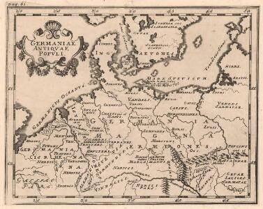
Germaniae Antiqvae Popvli
1 : 10750000 Mollova mapová sbírka Clüver, Philipp Fuhrmann, Mathias
Central Europe. Pergamon World Atlas.
1 : 2500000 Polish Army Topography Service
Geschichtl. Entwicklung d. Königr. Preussen vom Frieden von Tilsit (1807) bis jetzt
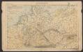
Deutschland
Kleine geologische Karte von Deutschland / bearb. von W. Schriel ; hrsg. von der Preussischen Geologischen Landesanstalt
1 : 2000000 Annotatie: Bijbehorend materiaal (Erläuterungen. - Ibid., 1930. - 28 p. : ill. ; 21 cm + krt) apart opgeborgen in legendakast Schriel, Walter; Preussische Geologische Landesanstalt Berlin : Preussische Geologische Landesanstalt
Nova Germaniae Descriptio
1 : 3100000 Mollova mapová sbírka Janssonius, Johannes Janssonius, Johannes I
Mapa teatru wojny na morzu i na lądzie
1 : 3000000 Belgie Scheda, Joseph von Steinhauser, Anton Artaria
Německá říše
1 : 3250000 Evropa střední Státní nakladatelství
Map of the German Empire.
1 : 3700000 Warner & Beers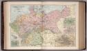
The Germany 21
1 : 2700000 Appleton, D. & Co.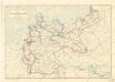
Karte der deutschen Wasser Wasserstrassen
Deutsches Reich
Volksschul-Atlas über alle Teile der Erde Lange, Henry Druck und Verlag von Georg Westermann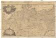
Carte des expeditions de la gverre presente en Allemagne, ou sont exactement marqués les mouvements, les grands chemins, les routes, marches, campemens, les attaques, les sieges, batailles & les postes occupés par les trouppes autrichiennes, & par leurs alliés, par les armées suedoises, russiennes, & par celles combinées de la France & de l'Empire, contre les trouppes du roi de Prusse & Hannovriennes, depuis l'entrée de l'armée prussienne en saxe l'an 1756. jusqu a l'an 1759
1 : 1290000 Evropa střední Rizzi Zannoni, Giovanni Antonio Lauredano, Francisco Joh. Ant. Rizzi Zannoni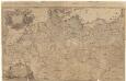
79-80. Europe, Central. The World Atlas.
1 : 2500000 USSR (Union of Soviet Socialist Republics).
Germania Augustiniana
1 : 3700000 Mollova mapová sbírka Seutter, Matthäus Seutter, Matthäus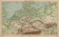
Mitteleuropa. Bodengestalt
1 : 4000000 Mitteleuropa Physische Geografie
Neueste Post Karte von Deutschland und dessen angrenzenden Länder
Evropa střední Jättnig, Karl Simon Schropp
Post- und Eisenbahnkarte des Deutschen Reichs und der angrenzenden lander
1 : 3000000 [Lieu de publication inconnu] : [éditeur inconnu]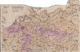
Mitteleuropa Volksdichte
1 : 6000000 Mitteleuropa Bevölkerungsdichte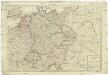
Deutschland nach seiner neuesten Grenz-Berichtigung
1 : 2350000 Evropa střední Mollo, Tranquillo T. Mollo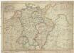
Deutschland nach seiner neuesten Grenz-berichtigung
1 : 2350000 Evropa střední Mollo, Tranquillo T. Mollo
Deutschland nach seiner neuesten Grenz-Berichtigung
1 : 2370000 Evropa střední Mollo, Tranquillo bey T. Mollo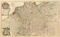
Composite: L'Alemagne.
1 : 1800000 Rizzi Zannoni, Giovanni Antonio Bartolomeo, 1736-1814
Deutschland zur Zeit des 30 jaehrigen Krieges.
1 : 3800000 Spruner von Merz, Karl
Neueste Laendereintheilung nach dem Frieden von Tilsit (9t[er] July 1807) oder Deutschland nebst angränzenden Ländern
Reise-, Post- und Zoll-Karte von Deutschland
1 : 2220000 Německo Hoffmann, Karl Friedrich Vollrath Erno, E. Carl Hoffmann
Nova Totius Germaniae descriptio Teutschland
1 : 4300000 Mollova mapová sbírka Merian, Matthäus Merian, Matthäus - dědici
Prussia, German States.
1 : 4400000 Mitchell, Samuel Augustus
Prussia, German States.
1 : 4400000 Mitchell, Samuel Augustus
Prussia, German States.
1 : 4400000 Mitchell, Samuel Augustus Jr.
Prussia, German States.
1 : 4400000 Mitchell, Samuel Augustus
Prussia, German States.
1 : 4400000 Mitchell, Samuel Augustus