Maps of Aegean

Feuille No. 1, uit: Carte de la Turquie d'Asie (moins l'Arabie) / dessiné et héliogravé au Service géographique de l'Armée
1 : 1000000 titelvariant: Turquie d'Asie; Annotatie: Titel boven de kaart: Turquie d'Asie; Bl. genummerd 1-4 en 7-10; Met lijst van de meest gebruikte woorden op de kaart vertaald uit het Turks, Arabisch en Perzisch; Annotatie geografische gegevens: Inzetkrt. op bl. 9: Plan de Jérusalem et de ses environs, Plan d'Alep, Plan de Damas et de ses faubourgs, Plan de Beyrout et de ses environs (alle 1:50.000) Service géographique de l'Armée [S.l. : Service géographique de l'Armée]
[Specialkarte der Asiatischen Türkey, I. Blatt; Anadoli (Kleinasien)]
Grosser Hand-Atlas über alle Theile der Erde in 170 Karten Meyer, J. Verlag des Bibliographischen Instituts
Asiat. Turkey 1.
1 : 2050000 Grassl, J. (Joseph)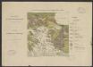
Carte géologique de la mer Egée par Mr L. de Launay : et des régions avoisinantes au 1/3 500 000e
1 : 3500000 Launay, L. de Paris :
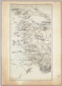
90. Anatolia occidentale, Isole Egee.
1 : 1500000 Touring club italiano
Europ. Turkey IV.
1 : 1740000 Grassl, J. (Joseph)
[Europäische Türkey in IV Blättern]
Grosser Hand-Atlas über alle Theile der Erde in 170 Karten Meyer, J. Verlag des Bibliographischen Instituts
Thracia Vetus
1 : 1100000 Mollova mapová sbírka Covens, Johannes Covens, Johannes I
Grecian Archipelago, ancient.
1 : 1860000 Society for the Diffusion of Useful Knowledge (Great Britain)
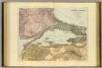
[Marmarameer]
Türkei Marmarameer Seeschlacht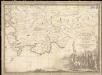
Parte dell'Asia Minore per servire di VI foglio della carta generale dell'Ungheria e della Turchia Europea
1 : 1
[Die Balkan-Halbinsel, Blatt 4]
Adolf Stieler's Handatlas über alle Theile der Erde und über das Weltgebäude Stieler, Adolf Justus Perthes
Grecian archipelago
1 : 1840000 Egejské ostrovy (Řecko a Turecko) Smith, William Walker, C. Society for the diffusion of useful knowledge
Balkans 1 000 000e. Constantinople
1 : 1000000 France. Service géographique de l'armée [Paris] : Service géographique de l'armée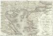
Carte de la Turquie d'Europe
1 : 1300000 Egejské moře-oblast Konrad, Al. Palma, Gaetano
Boundary of demilitarized zone about Constantinople
1 : 1000000 Meeting of Alllied Naval and Military Advisers, London 16.2.20. Demilitarized zones in north-west Turkey. Illustrates post-war settlement. War Office
Demilitarized zones in north-west Turkey
1 : 1000000 Demilitarized zones in north-west Turkey. Illustrates post-war settlement. War Office
Iles de L'archipel; Dschezaïr
Nouvel atlas physique politique et historique de l'Empire ottoman et des états limitrophes en Europe, en Asie et en Afrique, en quarante feuilles Hellert, J.J. Bellizard, Dufour et Cie
Das Ägäische Meer mit Kreta
1 : 1750000 Egejské moře (oblast) Carl Flemming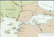
[Konstantinopel]
Istanbul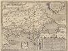
Thraciae Veteris Typus. [Karte], in: Theatrum orbis terrarum, S. 511.
1 Karte aus Atlas Ortelius, Abraham Vrients, Jan Baptista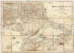
Karte vom Östlichen Rumelien
1 : 540000 Východní Rumelie Kiepert, Heinrich Dietrich Reimer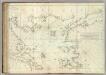
Carte De La Mer Mediterranee. XII.
Roux, Joseph
B2. Brussa. / bearbeitet von Richard Kiepert. 1902-1916.
From 1st Edition, 1:400,000. 1904-1907.
Archipelagi Meridionalis seu Cycladum Insularum accurata Delineatio. [Karte], in: Novus atlas absolutissimus, Bd. 10, S. 234.
1 Karte aus Atlas Janssonius Offizin
CYCLADES | INSVLÆ | IN MARE ÆGÆO, | hodie | ARCHIPELAGO
Auctore | I. LAVRENBERGIO Amsterdami, J. Blaeu excudit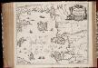
Insvlarvm Archipelagi Septentrionalis seu Maris Aegaei accurata delinatio / autore I. Laurenbergio
1 : 1100000 Annotatie: Jaar van uitg. van kaart ligt in de periode 1650-1662; Origineel is Blad 172 in atlas factice; Verso is blanco; Annotatie geografische gegevens: 4 schaalstokken op de kaart: 7 Mil. Germ., en: 10 Mil. Gall., en: 28 Mil. Ital., en 275 Stadia [Amstelodami] : [Apud Ioannem Ianssonium]
Insularum Archipelagi Septentrionalis seu Maris Aegaei Accurata Delinatio [Karte], in: Novus atlas absolutissimus, Bd. 10, S. 219.
1 Karte aus Atlas Janssonius Offizin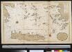
Het zuijderdeel van de Archipel Lagusche Eijlanden int groodt
Greece Gerard van Keulen