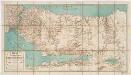
Maps of Konya

Feuille No. 2, uit: Carte de la Turquie d'Asie (moins l'Arabie) / dessiné et héliogravé au Service géographique de l'Armée
1 : 1000000 titelvariant: Turquie d'Asie; Annotatie: Titel boven de kaart: Turquie d'Asie; Bl. genummerd 1-4 en 7-10; Met lijst van de meest gebruikte woorden op de kaart vertaald uit het Turks, Arabisch en Perzisch; Annotatie geografische gegevens: Inzetkrt. op bl. 9: Plan de Jérusalem et de ses environs, Plan d'Alep, Plan de Damas et de ses faubourgs, Plan de Beyrout et de ses environs (alle 1:50.000) Service géographique de l'Armée [S.l. : Service géographique de l'Armée]
[Türkische Nordküste um Eregli]
1 Karte : Kupferdruck ; 18 x 13 cm [Trattner]
Bataille d'Angora
Nouvel atlas physique politique et historique de l'Empire ottoman et des états limitrophes en Europe, en Asie et en Afrique, en quarante feuilles Hellert, J.J. Bellizard, Dufour et Cie
Plan sraženīja pri Penderaklīi
Seeschlacht Türkei Schwarzes Meer Russisch-Türkischer Krieg <1828-1829>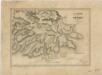
Olympos bei Brussa gezeichnet von Bernhard Blaue

[Specialkarte der Asiatischen Türkey, I. Blatt; Anadoli (Kleinasien)]
Grosser Hand-Atlas über alle Theile der Erde in 170 Karten Meyer, J. Verlag des Bibliographischen Instituts
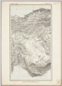
Übersichtskarte von Kleinasien
1 : 2500000 Bospor (Turecko : průliv) Friedrich, Ernst Verlag v. G. Sternkopf
Asiat. Turkey 1.
1 : 2050000 Grassl, J. (Joseph)
Feuille 40 (E VI), uit: Carte géologique internationale de l'Europe : la carte, votée au congrès géologique international de Bologne en 1881, est exécutée conformément aux décisions d'une commission internationale, avec le concours des gouvernements, sous le dir. de M.M. Beyrich et Hauchecorne
Annotatie: Blad 48 gamme des couleurs; blad 49: bladwijzer en titelblad Heinrich Ernst Beyrich 1815-1896; Wi. Hauchecorne Berlin : Reimer / (Berlin: Institut lithographique)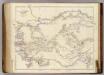
Map of Asia Minor.
1 : 1520640 Arrowsmith, John
Asie Mineure
Nouvel atlas physique politique et historique de l'Empire ottoman et des états limitrophes en Europe, en Asie et en Afrique, en quarante feuilles Hellert, J.J. Bellizard, Dufour et Cie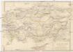
Asia Minor
1 : 2900000 Malá Asie Walker, C. Baldwin & Cradock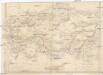
Turkey
1 : 2900000 Malá Asie Walker, C. Baldwin & Cradock
Asiae Minoris
1 : 2100000 Malá Asie Dehn, Em. M. Berra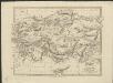
Turkey containing the provinces in Asia Minor
1 : 2900000 published under the superintendence of the Society for the Diffusion of Useful Knowledge engraved by J. & C. Walker London : Baldwin and Cradock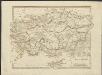
Asia Minor
1 : 3000000 published under the superintendence of the Society for the Diffusion of Useful Knowledge engraved by J. & C. Walker London : Baldwin and Cradock
Universae Graeciae antiquae tabula geographica
1 : 1350000 Ilýrie Kruse, Friedrich Klein, Ernst sumtibus Ernesti Klein
Asia Minor.
1 : 5000000 Mitchell, Samuel Augustus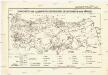
Standorte der landwirtschaftlichen Erzeugung in der Türkei
1 : 2000000 Turecko M. Müller & Sohn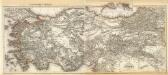
Composite: Asiat. Turkey.
1 : 2050000 Grassl, J. (Joseph)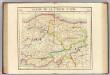
Partie, la Turquie d'Asie. Asie 51.
1 : 1641836 Vandermaelen, Philippe, 1795-1869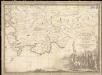
Parte dell'Asia Minore per servire di VI foglio della carta generale dell'Ungheria e della Turchia Europea
1 : 1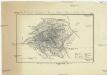
Topographische Skizze des Bulghar Dagh im cilicischen Taurus
1 : 250000 Taurus, pohoří (Turecko) Hotschy, Th.
B2. Brussa. / bearbeitet von Richard Kiepert. 1902-1916.
From 1st Edition, 1:400,000. 1904-1907.
B2. Brussa. / bearbeitet von Richard Kiepert. 1902-1916.
From 2nd Edition. 1: 400,000. 1908-1914.
A2. Constantinopel. / bearbeitet von Richard Kiepert. 1902-1916.
From 2nd Edition. 1: 400,000. 1908-1914.
Premières Possessions Territoriales
Nouvel atlas physique politique et historique de l'Empire ottoman et des états limitrophes en Europe, en Asie et en Afrique, en quarante feuilles Hellert, J.J. Bellizard, Dufour et Cie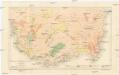
Geologische Übersichtskarte von Lykien
1 : 300000 Lýkie Tietze, Emil Ernst August Alfred Hölder
Karte der Gegend zwischen Bofanti und Tarsus
1 : 100000 Tarsus (Turecko) Kartographische Abteilung des Stellvertr. Generalstab der Armee