Maps of Kütahya

B2. Brussa. / bearbeitet von Richard Kiepert. 1902-1916.
From 2nd Edition. 1: 400,000. 1908-1914.
B2. Brussa. / bearbeitet von Richard Kiepert. 1902-1916.
From 1st Edition, 1:400,000. 1904-1907.
Premières Possessions Territoriales
Nouvel atlas physique politique et historique de l'Empire ottoman et des états limitrophes en Europe, en Asie et en Afrique, en quarante feuilles Hellert, J.J. Bellizard, Dufour et Cie
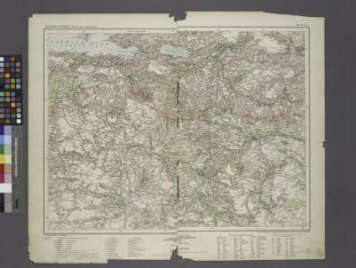
Sheet 5. 1: 250,000. / dressée par Henri Kiepert d'après ses propres observations et d'autres levées pour la plupart inédites = Map of the western part of Asia Minor
From Specialkarte vom westlichen Kleinasien nach seinen eigenen Reisen und anderen grösstenteils noch unveröffentlichten Routenaufnahmen bearbeitet von Heinrich Kiepert = Carte de la partie occidentale de l 'Asie mineure
Generalkarte von Zentraleuropa
Continuacion del mar de Mármara
Marmarské moře (Turecko) Velazques, J. Brieva, S.
Generalkarte von Zentraleuropa

[Marmarameer]
Türkei Marmarameer Seeschlacht
Boundary of demilitarized zone about Constantinople
1 : 1000000 Meeting of Alllied Naval and Military Advisers, London 16.2.20. Demilitarized zones in north-west Turkey. Illustrates post-war settlement. War Office
Demilitarized zones in north-west Turkey
1 : 1000000 Demilitarized zones in north-west Turkey. Illustrates post-war settlement. War Office
Übersichtskarte von Mittel - Europa
Sea of Marmara.
1 : 575300 Stanford, Edward
Gallipoli, Brussa
1 : 750000 Bursa (Turecko) Gstettner, G. K. u. k. Militärgeographisches Institut
Gallipoli, Brussa
1 : 750000 Bursa (Turecko) K. k. militär-geographisches Institut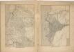
Kriegs Atlas 36 Karten von den Schauplätzen des Weltkrieges 1914/1915

Charte von der Strasse der Dardanellen oder Hellespont und dem Canal von Constantinopel (Bosporus) nebst dem Meer von Marmora
1 Karte : Kupferdruck ; 36 x 61 cm, Bildgrösse 49 x 63 cm Güssefeld; Faden; Le Chevalier bey A.G. Schneider u. Weigel
A2. Constantinopel. / bearbeitet von Richard Kiepert. 1902-1916.
From 2nd Edition. 1: 400,000. 1908-1914.
Charte von der Strasse der Dardanellen oder Hellespont und dem Canal Constantinopel (Bosporus) nebst dem Meer von Marmora mit den anliegenden Gegend von Europa und Asia
1 : 540000 Bospor (Turecko : průliv) Güssefeld, Franz L. Faden, W. A.G. Schneider u. Weigel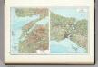
148. Dardanelles. Bosporus. The World Atlas.
1 : 500000 USSR (Union of Soviet Socialist Republics).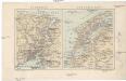
Bosporus, Dardanellen
Bospor (Turecko : průliv) F. A. Brouckaus' Geogr.-artist. Anstalt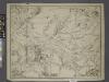
Sheet 8. 1: 250,000. / dressée par Henri Kiepert d'après ses propres observations et d'autres levées pour la plupart inédites = Map of the western part of Asia Minor
From Specialkarte vom westlichen Kleinasien nach seinen eigenen Reisen und anderen grösstenteils noch unveröffentlichten Routenaufnahmen bearbeitet von Heinrich Kiepert = Carte de la partie occidentale de l 'Asie mineure
Die Dardanellen in ihrer Lage zu Konstantinopel
Dardanellen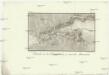
Estrecho de los Dardaneles, y mar de Mármara
Dardanely (Turecko : průliv) Velazques, J. Brieva, S.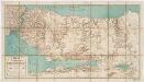
Karte des Bosporus und der Bithynischen Halbinsel
1 : 150000 Fitzner, Rudolph, b. 1864 C.J.E. Volckmann-Verlag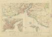
Constantinople & surrounding country, G.S.G.S. no 2390 (Sheet 1)
Constantinople & surrounding country, G.S.G.S. no 2390. Great Britain. War Office. General Staff. Geographical Section. [London] : Geographical Section, General Staff
Italien und Balkanhalbinsel. Nebenkarten II. 2. Konstantinopel und der Bosporus
Istanbul, Bosporus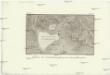
Plano de Constantinopla y sus inmediaciones
Istanbul (Turecko) Aguado, A. Vazques, J.
Plan von Constantinopel, mit der umliegenden Gegend, und des Canals vom Schwarzen Meer = Plan de la ville de Constantinople, des places voisines, et du Canal de Pont Euxine
1 : 85000 verlegt von Tob. Conr. Lotter in Augsburg Augsburg : Tob. Conr. Lotter
Asiat. Turkey 1.
1 : 2050000 Grassl, J. (Joseph)