Maps of okres Nový Jičín

156. Hultschin, uit: Topographische Uebersichtskarte des Deutschen Reiches / herausgegeben v. d. Kartogr. Abt. d. Königl. Preuß. Landesaufnahme
1 : 200000 titelvariant: Topogr. Übersichtskarte des Deutschen Reiches; Annotatie: Titel boven bladen ook: Topogr. Übersichtskarte des Deutschen Reiches; Annotatie geografische gegevens: Op elk blad twee maatstokken: 10 Kilometer = 5,5 cm; 1 geogr. Meile = 3,6 cm; Legenda onder op elk blad Königlich Preußische Landesaufnahme. Kartographische Abtheilung [S.l : Königlich Preußische Landesaufnahme, Kartographische Abtheilung]

Generální mapa okresního hejtmanství Opavského
1 : 250000 Opava-oblast (Česko) Wagner, Jan Eduard F. Kytka
Sprachgrenzlandschaft v. Westschlesien, Hultschin, Kuhland
1 : 150000 Hlučínsko Sobotik, Robert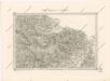
Special - Karte der Markgrafschaft Maehren und des Herzogthums Schlesien
II. vojenské mapování 5
1 : 144000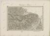
II. vojenské mapování 5
1 : 144000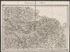
Umgebungen von Troppau
1 : 144000 K.K. Militärisches Geographisches Institut
II. vojenské mapování 5
1 : 144000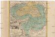
Die Fürstenthümer Troppau und Iaegerndorf in Ober-Schlesien
1 : 420000 Krnov-oblast (Česko) Schleuen, Johann David I.D. Schleuen
Podrobná místopisná mapa Království Českého

Podrobná mapa Markrabství moravského a Vévodství slezkého
1 : 100000 Bílovec (Česko : oblast) Srp, Jan Jos. R. Vilímek
Příruční mapa okresu Nový Jičín

Okresní hejtmanství Novojičínské

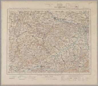
Troppau
from Spezialkarte der osterreichisch-ungarischen Monarchie.
Neutitschein
1 : 75000 Frenštát pod Radhoštěm (Česko : oblast) Fitz K. u. k. Militärgeographisches Institut
Freudenthal.
from Spezialkarte der osterreichisch-ungarischen Monarchie.
III. vojenské mapování 4159
1 : 75000
III. vojenské mapování 4160
1 : 75000
Karte des Gemeindegrenzen

III. vojenské mapování 4059
1 : 75000
Opava
1 : 75000 Bílovec (Česko : oblast) Vojenský zeměpisný ústav
Opava
1 : 75000 Bílovec (Česko : oblast) Kartografické odd. při Min. nár. obrany
Troppau
1 : 75000 Morava (Česko) Schuberth K. u. k. Militärgeographisches Institut
Hranice a okolí

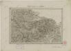
Mahrisch - Weisskirchen.
from Spezialkarte der osterreichisch-ungarischen Monarchie.
Neutitschenein.
from Spezialkarte der osterreichisch-ungarischen Monarchie.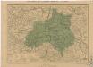
Generální mapa okresních hejtmanství

Mapa hejtmanství Hranického

Bruntál
1 : 75000 Bruntál (Česko : oblast) Vojenský zeměpisný ústav
Bruntál
1 : 75000 Bruntál-oblast (Česko) Vojenský zeměpisný ústav