Maps of okres Opava

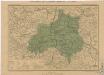
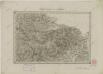
Principatvs Silesiae Oppaviensis novissima tabula geographica
1 : 150000 Opava-oblast (Česko) Wieland, Johann Wolfgang Schubarth, Matthäus Homannianos Heredes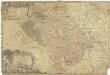
Principatvs Silesiae Oppaviensis novissima tabula geographica
1 : 150000 Opava-oblast (Česko) Wieland, Johann Wolfgang Schubarth, Matthäus Homannianos Heredes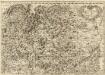
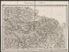
Tabula Generalis Marchionatus Moraviae in sex circulos divisae]
1 : 183000 Mollova mapová sbírka Müller, Johann Christoph Gastl, Jan Jiří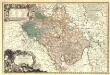
Principatvs Silesiae Oppaviensis novissima Tabula geographica.
1 : 150000 Mollova mapová sbírka Wieland, Johann Wolfgang Homann, Johann Baptista - dědici
Marchionatus Moraviae Circulus Preroviensis.
1 : 233300 Mollova mapová sbírka Müller, Johann Christoph Homann, Johann Baptista
Marchionatus Moraviae circulus Preroviensis
1 : 150000 Morava (Česko) Müller, Johann Christoph Homann, Johann Baptist Io. Baptista Homanno
Marchionatus Moraviae circulus Preroviensis
1 : 150000 Morava (Česko) Müller, Johann Christoph Homann, Johann Baptist Io. Baptista Homanno
Marchionatus Moraviae circulus Preroviensis
1 : 150000 Morava (Česko) Müller, Johann Christoph Homann, Johann Baptist editore Io. Baptista Homanno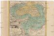
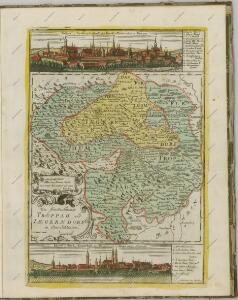
Die Fürstenthümer Troppau und Iaegerndorf in Ober-Schlesien
1 : 420000 Krnov-oblast (Česko) Schleuen, Johann David I.D. Schleuen
156. Hultschin, uit: Topographische Uebersichtskarte des Deutschen Reiches / herausgegeben v. d. Kartogr. Abt. d. Königl. Preuß. Landesaufnahme
1 : 200000 titelvariant: Topogr. Übersichtskarte des Deutschen Reiches; Annotatie: Titel boven bladen ook: Topogr. Übersichtskarte des Deutschen Reiches; Annotatie geografische gegevens: Op elk blad twee maatstokken: 10 Kilometer = 5,5 cm; 1 geogr. Meile = 3,6 cm; Legenda onder op elk blad Königlich Preußische Landesaufnahme. Kartographische Abtheilung [S.l : Königlich Preußische Landesaufnahme, Kartographische Abtheilung]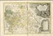
II. vojenské mapování 5
1 : 144000
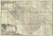
Generální mapa okresního hejtmanství Opavského
1 : 250000 Opava-oblast (Česko) Wagner, Jan Eduard F. Kytka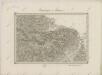
II. vojenské mapování 5
1 : 144000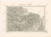
Special - Karte der Markgrafschaft Maehren und des Herzogthums Schlesien
Umgebungen von Troppau
1 : 144000 K.K. Militärisches Geographisches Institut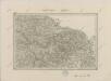
II. vojenské mapování 5
1 : 144000
Sprachgrenzlandschaft v. Westschlesien, Hultschin, Kuhland
1 : 150000 Hlučínsko Sobotik, Robert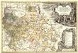
Principatvs Silesiae Karnoviensis nova et exactissima Tabula geographica, commonstrans insimul districtus ac Statvs Minores Frevdenthal Olbersdorf et Stevberndorf.
1 : 1125000 Mollova mapová sbírka Wieland, Johann Wolfgang Homann, Johann Baptista - dědici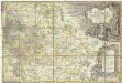
Principatvs Silesiae Karnoviensis nova et exactissima tabula geographica commonstrans insimul districtus ac statvs minores Frevdenthal, Olbersdorf et Stevberndorf
1 : 100000 Bruntál-oblast (Česko) Wieland, Johann Wolfgang Schubarth, Matthäus Homannianos Heredes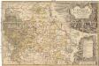
Principatvs Silesiae Karnoviensis nova et exactissima tabula geographica commonstrans insimul districtus ac statvs minores Frevdenthal Olbersdorf et Stevberndorf
1 : 100000 Bruntál-oblast (Česko) Wieland, Johann Wolfgang Schubarth, Matthäus ab Haeredibus Homannianis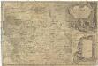
Principatvs Silesiae Karnoviensis nova et exactissima tabula geographica commonstrans insimul districtus ac Statvs minores Frevdenthal, Olbersdorf et Stevberndorf
1 : 100000 Bruntál-oblast (Česko) Wieland, Johann Wolfgang Schubarth, Matthäus Homannianos Heredes
Theil von Schlesien.
Slezsko (Polsko) Weiland, Karl Ferdinand Bürck, A. im Verlage des Geograph. Instituts
Freudenthal.
from Spezialkarte der osterreichisch-ungarischen Monarchie.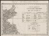
Umgebungen von Jägerndorf und die statistische Uebersicht
1 : 144000 K.K. Militärisches Geographisches Institut
Jacerndorf.
from Spezialkarte der osterreichisch-ungarischen Monarchie.
Troppau
from Spezialkarte der osterreichisch-ungarischen Monarchie.
Reymann ́s Special Karte 190 Troppau