Maps of Landkreis Bad Kissingen

140. Schweinfurt, uit: Topographische Uebersichtskarte des Deutschen Reiches / herausgegeben v. d. Kartogr. Abt. d. Königl. Preuß. Landesaufnahme
1 : 200000 titelvariant: Topogr. Übersichtskarte des Deutschen Reiches; Annotatie: Titel boven bladen ook: Topogr. Übersichtskarte des Deutschen Reiches; Annotatie geografische gegevens: Op elk blad twee maatstokken: 10 Kilometer = 5,5 cm; 1 geogr. Meile = 3,6 cm; Legenda onder op elk blad Königlich Preußische Landesaufnahme. Kartographische Abtheilung [S.l : Königlich Preußische Landesaufnahme, Kartographische Abtheilung]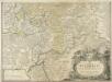
S. R. I. Principatvs Fvldensis in Bvchonia
1 : 210000 Mollova mapová sbírka Homann, Johann Baptist Homann, Johann Baptista
[Dolní Franky]
1 : 219000 Bad Kissingen (Německo) Loehle, Johann Kunstanstalt von Piloty u. Loehle
Neueste Karte des heiligen Kreuzberges und seiner Umgebungen, mit den Rhoengebirgen und angrenzenden Orten
1 : 225000 Rhön (Německo) Richter, Johann Stephan Johann Stephan Richter
Meßtischblatt 5924 : Gemünden, 1939
1 : 250000 Gemünden. - Aufn. 1902, Erkund. 1936/37, bericht. 1939. - 1:25000. - München: Hauptvermessungsabteilung XII, 1939. - 1 Kt.
Meßtischblatt 5923 : Rieneck, 1938
1 : 250000 Rieneck. - Aufn. 1902, Erkund. 1937/38, bericht. 1938, preuß. Teil: Stand 1931. - 1:25000. - München: Bayer. Landesvermessungsamt, 1938. - 1 Kt.
Meßtischblatt 5922 : Frammersbach, 1938
1 : 250000 Frammersbach. - Aufn. 1902, Erkund. 1937/38, bericht. 1938, preuß. Teil: Stand 1931. - 1:25000. - München: Hauptvermessungsabteilung XIII, 1938. - 1 Kt.
Meßtischblatt 5723 : Altengronau, 1942
1 : 250000 Altengronau. - Bericht. 1937, hrsg. 1939, Ausg. 1942. - 1:25000. - [Berlin]: Reichsamt für Landesaufnahme, 1942. - 1 Kt.
Meßtischblatt 3282 : Schlüchtern, 1906
1 : 250000 Schlüchtern. - Aufn. 1904. - 1:25000. - [Berlin]: Kgl. Preuss. Landesaufnahme, 1906. - 1 Kt.
Meßtischblatt 3281 : Steinau, 1935
1 : 250000 Steinau. - Hrsg. 1906, einz. Nachtr. 1935. - 1:25000. - [Berlin]: Reichsamt für Landesaufnahme, 1935. - 1 Kt.
Meßtischblatt 5527 : Ostheim v. d. Rhön, 1952
1 : 250000 Ostheim v. d. Rhön. - Hrsg. 1906. - 1:25000. - [Berlin]: Vermessungsdienst des Landes Sachsen-Anhalt, 1952. - 1 Kt.
Meßtischblatt 428 : Ostheim, 1874
1 : 250000 Ostheim. - Aufn. 1857. - 1:25000. - [Berlin]: Kgl. Preuss. Min. f. Handel, 1874. - 1 Kt.
Meßtischblatt 5525 : Gersfeld, 1936
1 : 250000 Gersfeld. - Hrsg. 1906, bericht. 1926, einz. Nachtr. 1936. - 1:25000. - [Berlin]: Reichsamt für Landesaufnahme, 1936. - 1 Kt.
Meßtischblatt Gersfeld
1 : 250000 Gersfeld. - Aufn. 1869. - 1:25000. - [Berlin]: Reichsamt für Landesaufnahme, 1874. - 1 Kt.
Meßtischblatt 3227 : Neuhof, 1939
1 : 250000 Neuhof. - Hrsg. 1906, Ausg. 1939. - 1:25000. - [Berlin]: Reichsamt für Landesaufnahme, 1939. - 1 Kt.
Meßtischblatt 3227 : Neuhof, 1929
1 : 250000 Neuhof. - Hrsg. 1906, bericht. 1929. - 1:25000. - [Berlin]: Reichsamt für Landesaufnahme, 1929. - 1 Kt.
Meßtischblatt Freiensteinau (Hintersteinau)
1 : 250000 Freiensteinau (Hintersteinau). - Bearb. 1911, Nachtr. 1928, einz. Nachtr. 1933. - 1:25000. - Darmstadt: Hess. Landesvermessungsamt, 1933. - 1 Kt.
Pharus - Plan Bad Kissingen

Kissingen
1 : 2500 gravirt von F. Endl. [S.l.] : [s.n.]
Kissingen 100, uit: [W. Liebenow's Special-Karte von Mittel-Europa]
1 : 300000 titelvariant: W. Liebenow's Mittel-Europa; Annotatie: Titel boven de bladen: W. Liebenow's Mittel-Europa Johannes Wilhelm Liebenow 1822-1897 Hannover : Hermann Oppermann
Fulda
1 : 300000 R. Mittelbach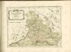

Reverendissimo Et Celsissimo S. R. I. Principi Constantino Sanctae Fuldensis Ecclesiae Abbati Augustissimae Romanorum Imperatricis Archi-Cancellario Per Germaniam Galliamque Primati Hanc Novam Veteris Buchoniae Tabulam Unacum Suis Confinys Dedicat Consecratque
1 : 340000 Mollova mapová sbírka Schannat, Johann Friedrich Puschner, Johann Georg
Buchaviae, sive Fuldensis Ditionis Typus. [Karte], in: Theatrum orbis terrarum, S. 236.
1 Karte aus Atlas Ortelius, Abraham Vrients, Jan Baptista

Kissingen 100, uit: Special-Karte von Mittel-Europa / nach amtlichen Quellen bearbeitet von W. Liebenow
1 : 300000 titelvariant: W. Liebenow's Mittel-Europa; Annotatie: Titel boven de bladen: W. Liebenow's Mittel-Europa Johannes Wilhelm Liebenow 1822-1897 Frankfurt a. M. : Ludwig Ravenstein
Buchaviae, sive Fuldensis Ditionis Typus. [Karte], in: Theatrum orbis terrarum, S. 144.
1 Karte aus Atlas Ortelius, Abraham
S.R.I. principatus Fuldensis in Buchonia
1 : 206000 Fulda (Německo) Homann, Johann Baptist Ioh. Baptista Homanno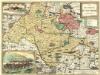
Das Bisthum Wurtzburg in Francken
1 : 280000 Mollova mapová sbírka Seyfried, Johann Heinrich Schollenberger, Johann Jakob Hoffmann, Johann


