Maps of Landkreis Bad Kissingen

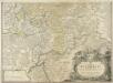
Kissingen 100, uit: [W. Liebenow's Special-Karte von Mittel-Europa]
1 : 300000 titelvariant: W. Liebenow's Mittel-Europa; Annotatie: Titel boven de bladen: W. Liebenow's Mittel-Europa Johannes Wilhelm Liebenow 1822-1897 Hannover : Hermann Oppermann
Kissingen 100, uit: Special-Karte von Mittel-Europa / nach amtlichen Quellen bearbeitet von W. Liebenow
1 : 300000 titelvariant: W. Liebenow's Mittel-Europa; Annotatie: Titel boven de bladen: W. Liebenow's Mittel-Europa Johannes Wilhelm Liebenow 1822-1897 Frankfurt a. M. : Ludwig Ravenstein
Buchaviae, sive Fuldensis Ditionis Typus. [Karte], in: Theatrum orbis terrarum, S. 144.
1 Karte aus Atlas Ortelius, Abraham
Buchaviae, sive Fuldensis Ditionis Typus. [Karte], in: Theatrum orbis terrarum, S. 236.
1 Karte aus Atlas Ortelius, Abraham Vrients, Jan Baptista
S. R. I. Principatvs Fvldensis in Bvchonia
1 : 210000 Mollova mapová sbírka Homann, Johann Baptist Homann, Johann Baptista
Reverendissimo Et Celsissimo S. R. I. Principi Constantino Sanctae Fuldensis Ecclesiae Abbati Augustissimae Romanorum Imperatricis Archi-Cancellario Per Germaniam Galliamque Primati Hanc Novam Veteris Buchoniae Tabulam Unacum Suis Confinys Dedicat Consecratque
1 : 340000 Mollova mapová sbírka Schannat, Johann Friedrich Puschner, Johann Georg
Fulda
1 : 300000 R. Mittelbach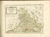

S.R.I. principatus Fuldensis in Buchonia
1 : 206000 Fulda (Německo) Homann, Johann Baptist Ioh. Baptista Homanno
140. Schweinfurt, uit: Topographische Uebersichtskarte des Deutschen Reiches / herausgegeben v. d. Kartogr. Abt. d. Königl. Preuß. Landesaufnahme
1 : 200000 titelvariant: Topogr. Übersichtskarte des Deutschen Reiches; Annotatie: Titel boven bladen ook: Topogr. Übersichtskarte des Deutschen Reiches; Annotatie geografische gegevens: Op elk blad twee maatstokken: 10 Kilometer = 5,5 cm; 1 geogr. Meile = 3,6 cm; Legenda onder op elk blad Königlich Preußische Landesaufnahme. Kartographische Abtheilung [S.l : Königlich Preußische Landesaufnahme, Kartographische Abtheilung]
S. R. I. Principatvs Fvldensis in Bvchonia
1 : 210000 Mollova mapová sbírka Homann, Johann Baptist Homann, Johann Baptista
Reverendissimo Et Celsissimo S. R. I. Principi Adolfo Sanctae Fuldensis Ecclesiae Abbati Augustissimae Romanorum Imperatricis Archi-Cancellario Per Germaniam Galliamque Primati hanc Eius Ditionis Simul Ac Dioecisis Tabulam Geographicam Monumentis Historicis Illustratam
1 : 230000 Mollova mapová sbírka Schannat, Johann Friedrich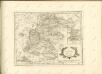

Bvchaviae, siue Fvldensis ditionis typvs
1 Karte : Kupferdruck ; 30 x 21 cm Regerwyl; Ortelius s.n.
[Dolní Franky]
1 : 219000 Bad Kissingen (Německo) Loehle, Johann Kunstanstalt von Piloty u. Loehle
Neueste Karte des heiligen Kreuzberges und seiner Umgebungen, mit den Rhoengebirgen und angrenzenden Orten
1 : 225000 Rhön (Německo) Richter, Johann Stephan Johann Stephan Richter
Meßtischblatt 6024 : Karlstadt, 1941
1 : 250000 Karlstadt. - Aufn. 1937, Ausg. 1939, bereinigt 1941. - 1:25000. - München, 1941. - 1 Kt.
Meßtischblatt 6023 : Lohr, 1941
1 : 250000 Lohr. - Aufn. 1937, Ausg. 1939, bereinigt 1941. - 1:25000. - München: Hauptvermessungsabt. XIII, 1941. - 1 Kt.
Meßtischblatt 6022 : Rothenbuch, 1941
1 : 250000 Rothenbuch. - Aufn. 1937, Ausg. 1939, bereinigt 1941. - 1:25000. - München, 1941. - 1 Kt.
Meßtischblatt 6021 : Haibach, 1940
1 : 250000 Haibach. - Aufn. 1935, Ausg. 1936, einzelne Nachtr. 1940. - 1:25000. - München, 1940. - 1 Kt.
Meßtischblatt 5924 : Gemünden, 1939
1 : 250000 Gemünden. - Aufn. 1902, Erkund. 1936/37, bericht. 1939. - 1:25000. - München: Hauptvermessungsabteilung XII, 1939. - 1 Kt.
Meßtischblatt 5923 : Rieneck, 1938
1 : 250000 Rieneck. - Aufn. 1902, Erkund. 1937/38, bericht. 1938, preuß. Teil: Stand 1931. - 1:25000. - München: Bayer. Landesvermessungsamt, 1938. - 1 Kt.
Meßtischblatt 5922 : Frammersbach, 1938
1 : 250000 Frammersbach. - Aufn. 1902, Erkund. 1937/38, bericht. 1938, preuß. Teil: Stand 1931. - 1:25000. - München: Hauptvermessungsabteilung XIII, 1938. - 1 Kt.
Meßtischblatt 3375 : Bieber, 1935
1 : 250000 Bieber. - Hrsg. 1906, einz. Nachtr. 1931, gedr. [19]35. - 1:25000. - [Berlin]: Reichsamt für Landesaufnahme, [19]35. - 1 Kt.
Meßtischblatt 5723 : Altengronau, 1942
1 : 250000 Altengronau. - Bericht. 1937, hrsg. 1939, Ausg. 1942. - 1:25000. - [Berlin]: Reichsamt für Landesaufnahme, 1942. - 1 Kt.
Meßtischblatt 5628 : Königshofen i. Grabfeld, 1943
1 : 250000 Königshofen i. Grabfeld. - Vorläuf. Ausg. 1943. - 1:25000. - München, 1943. - 1 Kt.
Meßtischblatt 3282 : Schlüchtern, 1906
1 : 250000 Schlüchtern. - Aufn. 1904. - 1:25000. - [Berlin]: Kgl. Preuss. Landesaufnahme, 1906. - 1 Kt.
Meßtischblatt 3281 : Steinau, 1935
1 : 250000 Steinau. - Hrsg. 1906, einz. Nachtr. 1935. - 1:25000. - [Berlin]: Reichsamt für Landesaufnahme, 1935. - 1 Kt.
![Kissingen 100, uit: [W. Liebenow's Special-Karte von Mittel-Europa]](https://images-2.georeferencer.com/images/iiif/797113458269/full/,300/0/native.jpg)

