Maps of Herzogtum Lauenburg

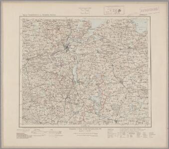
41. Lübeck, uit: Topographische Uebersichtskarte des Deutschen Reiches / herausgegeben v. d. Kartogr. Abt. d. Königl. Preuß. Landesaufnahme
1 : 200000 titelvariant: Topogr. Übersichtskarte des Deutschen Reiches; Annotatie: Titel boven bladen ook: Topogr. Übersichtskarte des Deutschen Reiches; Annotatie geografische gegevens: Op elk blad twee maatstokken: 10 Kilometer = 5,5 cm; 1 geogr. Meile = 3,6 cm; Legenda onder op elk blad Königlich Preußische Landesaufnahme. Kartographische Abtheilung [S.l : Königlich Preußische Landesaufnahme, Kartographische Abtheilung]
115. Schonberg in Mecklenbg. (Germany)
1 : 100000 Reichsamt fur Landesaufnahme

Composite: 115. Schonberg in Mecklenbg. (Germany)
1 : 100000 Reichsamt fur Landesaufnahme
114. Lubeck. (Germany)
1 : 100000 Reichsamt fur Landesaufnahme
Composite: 114. Lubeck. (Germany)
1 : 100000 Reichsamt fur Landesaufnahme
Composite: 147. Ratzeburg. (Germany)
1 : 100000 Reichsamt fur Landesaufnahme
Composite: 148. Wittenburg. (Germany)
1 : 100000 Reichsamt fur Landesaufnahme
148. Wittenburg. (Germany)
1 : 100000 Reichsamt fur Landesaufnahme
147. Ratzeburg. (Germany)
1 : 100000 Reichsamt fur Landesaufnahme
Meßtischblatt 2433 : Parum, 1943
1 : 250000 Parum. - Aufn. 1879, hrsg. 1881, letzte Nachtr. 1943. - 1:25000. - [Berlin]: Reichsamt für Landesaufnahme, 1943. - 1 Kt.
Meßtischblatt 2432 : Wittenburg, 1881
1 : 250000 Wittenburg. - Aufn. 1879. - 1:25000. - [Berlin]: Reichsamt für Landesaufnahme, 1881. - 1 Kt.
Meßtischblatt 2431 : Zarrentin, 1953
1 : 250000 Zarrentin. - Hrsg. 1881, Ausg. 1938. - 1:25000. - [S.l.]: VD S-A, 1953. - 1 Kt.
Meßtischblatt 2430 : Gudow, 1900
1 : 250000 Gudow. - Hrsg. 1881, letzte Nachtr. 1900. - 1:25000. - [Berlin]: Reichsamt für Landesaufnahme, 1900. - 1 Kt.
Meßtischblatt 1033 : Siebeneichen, 1881
1 : 250000 Siebeneichen. - Aufn. 1879. - 1:25000. - [Berlin]: Reichsamt für Landesaufnahme, 1881. - 1 Kt.
Meßtischblatt 218 : Schwarzenbek, 1881
1 : 250000 Schwarzenbek. - Aufn. 1879. - 1:25000. - [Berlin]: Reichsamt für Landesaufnahme, 1881. - 1 Kt.
Meßtischblatt 2333 : Gross- Brütz, 1881
1 : 250000 Gross- Brütz. - Aufn. 1879. - 1:25000. - [Berlin]: Reichsamt für Landesaufnahme, 1881. - 1 Kt.
Meßtischblatt 2332 : Gr. Salitz, 1954
1 : 250000 Gr. Salitz. - Hrsg. 1881, bericht. 1952, Ausg. 1954. - 1:25000. - [S.l.]: MdI, 1954. - 1 Kt.
Meßtischblatt 2331 : Seedorf, 1954
1 : 250000 Seedorf. - Hrsg. 1881, letzte Nachtr. 1924. - 1:25000. - [S.l.]: VD Mecklenburg, 1954. - 1 Kt.
Meßtischblatt 938 : Mölln, 1881
1 : 250000 Mölln. - Aufn. 1879. - 1:25000. - [Berlin]: Reichsamt für Landesaufnahme, 1881. - 1 Kt.
Meßtischblatt Nusse
1 : 250000 Nusse. - Aufn. 1879. - 1:25000. - [Berlin]: Reichsamt für Landesaufnahme, 1881. - 1 Kt.
Meßtischblatt 936 : Trittau, 1881
1 : 250000 Trittau. - Aufn. 1879. - 1:25000. - [Berlin]: Reichsamt für Landesaufnahme, 1881. - 1 Kt.
Meßtischblatt 2233 : Mühlen- Eichsen, 1924
1 : 250000 Mühlen- Eichsen. - Hrsg. 1879. - 1:25000. - [Berlin]: Reichsamt für Landesaufnahme, 1924. - 1 Kt.
Meßtischblatt 2232 : Gadebusch, 1924
1 : 250000 Gadebusch. - Hrsg. 1881, Ausg. 1924. - 1:25000. - [Berlin]: Reichsamt für Landesaufnahme, 1924. - 1 Kt.
Meßtischblatt 2231 : Carlow, 1919
1 : 250000 Carlow. - Hrsg. 1879, bericht. 1904, letzte Nachtr. 1919. - 1:25000. - [Berlin]: Reichsamt für Landesaufnahme, 1919. - 1 Kt.
Meßtischblatt 841, neue Nr. 2230 : Ratzeburg, 1937
1 : 250000 Ratzeburg. - Hrsg. 1881, einz. Nachtr. 1908, gedr. [19]37. - 1:25000. - [Berlin]: Reichsamt für Landesaufnahme, 1937. - 1 Kt.
Meßtischblatt 841 : Ratzeburg, 1908
1 : 250000 Ratzeburg. - Aufn. 1877/79, hrsg. 1881, einzelne Nachtr. 1908. - 1:25000. - [Berlin]: Reichsamt für Landesaufnahme, 1908. - 1 Kt.
Meßtischblatt 840 : Crummesse, 1898
1 : 250000 Crummesse. - Aufn. 1877/79, hrsg. 1881, einz. Nachtr. 1898. - 1:25000. - [Berlin]: Reichsamt für Landesaufnahme, 1898. - 1 Kt.
Meßtischblatt 839 : Eichede, 1898
1 : 250000 Eichede. - Aufn. 1877/79, hrsg. 1881, einz. Nachtr. 1898. - 1:25000. - [Berlin]: Reichsamt für Landesaufnahme, 1898. - 1 Kt.