Maps of Kecskeméti járás

Kecskemét 163, uit: Special-Karte von Mittel-Europa / nach amtlichen Quellen bearbeitet von W. Liebenow
1 : 300000 titelvariant: W. Liebenow's Mittel-Europa; Annotatie: Titel boven de bladen: W. Liebenow's Mittel-Europa Johannes Wilhelm Liebenow 1822-1897 Frankfurt a. M. : Ludwig Ravenstein
A Dunavölgy Átnézeti Térképe, Carte d ́ensemble del la Vallée du Danube XVI.

Mappa Comitatus Solthensis
1 : 170000 Mollova mapová sbírka Mikoviny, Sámuel Schmutzer, Andreas
Czegled.
from Spezialkarte der osterreichisch-ungarischen Monarchie.
Tisza-Inoka.
from Spezialkarte der osterreichisch-ungarischen Monarchie.
Szolnok.
from Spezialkarte der osterreichisch-ungarischen Monarchie.
Kiskunfelegyhaza und Szegvar.
from Spezialkarte der osterreichisch-ungarischen Monarchie.
Soltvadkert
1 : 75000 Soltvadkert, Bács-Kiskun
Cegléd
1 : 75000 Cegléd, Cegléd (Region)
Kiskunfélegyháza
1 : 75000 Kiskunfélegyháza, Bács-Kiskun
Szolnok
1 : 75000 Szolnok, Szolnok (Region)
Tisza-Inoka
1 : 75000 Komitat Jász-Nagykun-Szolnok
Soltvadkert.; Spezialkarte der osterreichisch-ungarischen Monarchie.
from Spezialkarte der osterreichisch-ungarischen Monarchie. Austro-Hungarian Monarchy. Militärgeographisches Institut.,
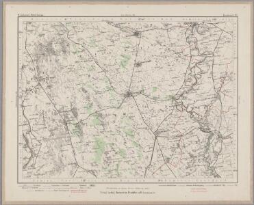
Kecskemet (Ungarn).; Spezialkarte der osterreichisch-ungarischen Monarchie.
from Spezialkarte der osterreichisch-ungarischen Monarchie. Austro-Hungarian Monarchy. Militärgeographisches Institut.,
Kecskemét
1 : 75000 Kecskemét
Dunafoldvar und Szabadszallas.
from Spezialkarte der osterreichisch-ungarischen Monarchie.
Dunaadony und Kunszentmiklos.
from Spezialkarte der osterreichisch-ungarischen Monarchie.
Rác-Adony
1 : 75000 Adony, Adony (Region)
Paks
1 : 75000 Paks, Komitat Tolna
Dunaföldvár
1 : 75000 Dunaföldvár, Dunaföldvár (Region)
Paks und Kalocsa.
from Spezialkarte der osterreichisch-ungarischen Monarchie.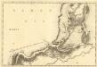
Erdsin - Feudwar
Mollova mapová sbírka Marsili, Luigi Ferdinando
A németek településterülete a szomszédsági mutató alapján Bács-Kiskun megyében 1941-ban
Bács-Kiskun Deutsche, Siedlung Bottlik, Zsolt

A németek településterülete a szomszédsági mutató alapján Bács-Kiskun megyében 1880-ban
Bács-Kiskun Deutsche, Siedlung Bottlik, Zsolt
Pesth-Solter, Csongráder, Szolnoker Comitat und das Ober Capitanat von Jazygien und Cumanien
1 : 280000 Budapešť-oblast (Maďarsko)
A németek településterülete a szomszédsági mutató alapján Bács-Kiskun megyében 1980-ban
Bács-Kiskun Deutsche, Siedlung Bottlik, Zsolt
A horvátok aránya és száma Bács-Kiskun megyében 1941-ben
Bács-Kiskun Kroaten, Siedlung Bottlik, Zsolt
C. Pestensis
Ungarn Komitat Pest