Maps of Dunaújváros
Erdsin - Feudwar
Mollova mapová sbírka Marsili, Luigi Ferdinando
Dunaadony und Kunszentmiklos.
from Spezialkarte der osterreichisch-ungarischen Monarchie.
Rác-Adony
1 : 75000 Adony, Adony (Region)
Dunafoldvar und Szabadszallas.
from Spezialkarte der osterreichisch-ungarischen Monarchie.
Dunaföldvár
1 : 75000 Dunaföldvár, Dunaföldvár (Region)
Fejér vármegye térképe
1 : 380000 Fejér (Maďarsko) Kogutowicz, Manó Magyar Földrajzi Intézet
C. Albensis
Ungarn Fejér
Comitat Stuhlweissenburg
1 : 300000
Comitat Stuhlweissenburg
1 : 280000 Székesfehérvár (Maďarsko)

Fejér válmegye
1 : 370000 Fejér (Maďarsko) Chiapó, Benjamin Benedicti, Hieronymus
Stuhlweissenburg 162, uit: Special-Karte von Mittel-Europa / nach amtlichen Quellen bearbeitet von W. Liebenow
1 : 300000 titelvariant: W. Liebenow's Mittel-Europa; Annotatie: Titel boven de bladen: W. Liebenow's Mittel-Europa Johannes Wilhelm Liebenow 1822-1897 Frankfurt a. M. : Ludwig Ravenstein
C. Pestensis
Ungarn Komitat Pest

Bez titulu: Západní Maďarsko

Pest-Pilis-Solt-Kiskun vármegye
1 : 500000 Budapešť (Maďarsko : oblast) Kogutowicz, Manó Magyar Földrajzi Intézet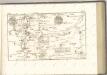
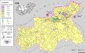
Siedlungsgebiet der Deutschen nach dem Nachbarschaftsindex für Mittel-Transdanubien 1980
Ungarn, Zentralungarn, Deutsche, Siedlung Bottlik, Zsolt
Pesth-Solter, Csongráder, Szolnoker Comitat und das Ober Capitanat von Jazygien und Cumanien
1 : 280000 Budapešť-oblast (Maďarsko)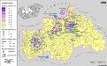
Siedlungsgebiet der Deutschen nach dem Nachbarschaftsindex für Mittel-Transdanubien 1880
Ungarn, Zentralungarn, Deutsche, Siedlung Bottlik, Zsolt
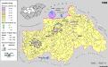
Siedlungsgebiet der Deutschen nach dem Nachbarschaftsindex für Mittel-Transdanubien 1941
Ungarn, Zentralungarn, Deutsche, Siedlung Bottlik, Zsolt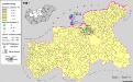
Siedlungsgebiet der Slowaken nach dem Nachbarschaftsindex für Mittel-Transdanubien 1941
Ungarn, Zentralungarn, Slowaken, Siedlung Bottlik, Zsolt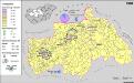
A németek településterülete a szomszédsági mutató alapján Közép-Dunántúlon 1980-ban
Ungarn, Zentralungarn, Deutsche, Siedlung Bottlik, Zsolt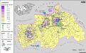
A németek településterülete a szomszédsági mutató alapján Közép-Dunántúlon 1880-ban
Ungarn, Zentralungarn, Deutsche, Siedlung Bottlik, Zsolt
Siedlungsgebiet der Slowaken nach dem Nachbarschaftsindex für Mittel-Transdanubien 1980
Ungarn, Zentralungarn, Slowaken, Siedlung Bottlik, Zsolt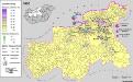
Siedlungsgebiet der Slowaken nach dem Nachbarschaftsindex für Mittel-Transdanubien 1880
Ungarn, Zentralungarn, Slowaken, Siedlung Bottlik, Zsolt
A szlovákok településterülete a szomszédsági mutató alapján Közép-Dunántúlon 1880-ban
Ungarn, Zentralungarn, Slowaken, Siedlung Bottlik, Zsolt
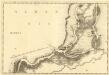
Mappa geographica almae dioecesis Weszprimiensis per inclytos comitatus Weszprim, Simigh et Zala
1 : 240000 Veszprém-oblast (Maďarsko) Vizer, Stephan Kopácsy, Joseph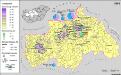
A németek településterülete a szomszédsági mutató alapján Közép-Dunántúlon 1941-ban
Ungarn, Zentralungarn, Deutsche, Siedlung Bottlik, Zsolt