Maps of Kauno

Kowno 9, uit: Special-Karte von Mittel-Europa / nach amtlichen Quellen bearbeitet von W. Liebenow
1 : 300000 titelvariant: W. Liebenow's Mittel-Europa; Annotatie: Titel boven de bladen: W. Liebenow's Mittel-Europa Johannes Wilhelm Liebenow 1822-1897 Frankfurt a. M. : Ludwig Ravenstein
[Kowno]
1 : 300000 Kaunas Belagerung, Weltkrieg <1914-1918>
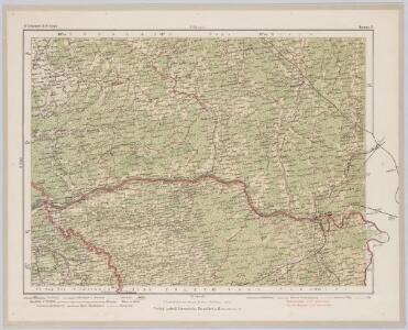
Meßtischblatt 12103 : Schirwindt, 1938
1 : 250000 Schirwindt. - Hrsg. 1915, bericht. 1927, redakt. Änd. 1938. - 1:25000. - [Berlin]: Reichsamt für Landesaufnahme, 1938. - 1 Kt.
Meßtischblatt 12101 : Pillkallen, 1931
1 : 250000 Pillkallen. - Hrsg. 1916, bericht. 1927. - 1:25000. - [Berlin]: Reichsamt für Landesaufnahme, 1931. - 1 Kt.
Meßtischblatt 12102 : Sodargen, 1940
1 : 250000 Sodargen. - Aufn. 1913, Hrsg. 1915, bericht. 1927, letzte Na. - 1:25000. - [Berlin]: Reichsamt für Landesaufnahme, 1940. - 1 Kt.
Meßtischblatt 11103 : Brämerhusen, 1938
1 : 250000 Brämerhusen. - Hrsg. 1915, bericht. 1927, redakt. Änd. 1938. - 1:25000. - [Berlin]: Reichsamt für Landesaufnahme, 1938. - 1 Kt.
Meßtischblatt 11101 : Grumbkowsfelde, 1940
1 : 250000 Grumbkowsfelde. - Aufn. 1913, hrsg. 1916, bericht. 1927, letzt. Na. - 1:25000. - [Berlin]: Reichsamt für Landesaufnahme, 1940. - 1 Kt.
Meßtischblatt 11102 : Schillfelde, 1939
1 : 250000 Schillfelde. - Aufn. 1913, hrsg. 1916, bericht. 1927, letzt. Na. - 1:25000. - [Berlin]: Reichsamt für Landesaufnahme, 1939. - 1 Kt.
Messstichblatt 10101 : Tulpeningen, 1938 Tulpeningen
1 : 250000 Tulpeningen. - Hrsg. 1915, bericht. 1927, redakt. Änd. 1938. - 1:25000. - [Berlin]: Reichsamt für Landesaufnahme, 1938. - 1 Kt.
Messtischblatt 10102-10103 : Grenzhöhe, 1927 Grenzhöhe
1 : 250000 Grenzhöhe. - Hrsg. 1915, bericht. 1927. - 1:25000. - [Berlin]: Reichsamt für Landesaufnahme, 1927. - 1 Kt.
Meßtischblatt 09101 : Schmalleningken, 1939
1 : 250000 Schmalleningken. - Hrsg. 1915, einzl. Nachtr. 1927, redakt. Änd. 1938. - 1:25000. - [Berlin]: Reichsamt für Landesaufnahme, 1939. - 1 Kt.
Meßtischblatt 08101 : Forst Schmalleningken, 1939
1 : 250000 Forst Schmalleningken. - Hrsg. 1915, redakt. Änd. 1939. - 1:25000. - [Berlin]: Reichsamt für Landesaufnahme, 1939. - 1 Kt.
Composite: 19. Wischwill. (Germany)
1 : 100000 Reichsamt fur Landesaufnahme
19. Wischwill. (Germany)
1 : 100000 Reichsamt fur Landesaufnahme
Generalkarte von Zentraleuropa

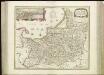
Regni Borussiae Episcopatus Warmiensis Palatinatus Mariaeburgensis et Culmensis cum Territorio Dantiscano et Ichnographia Urbis Regiomontis].
Mollova mapová sbírka
Sect. 5. Jura (Das Jura Becken (Schalaunen)), uit: Geologische Karte der Provinz Preussen
1 : 100000 Annotatie: Incompleet; Voor aanwezige bladen zie bladoverzicht; Met inzetkaarten; Annotatie geografische gegevens: Coördinaten gebaseerd op nulmeridiaan van Ferro (Hierro) Berlin : Neumann
Composite: 33. Pillkallen. (34. Schirwindt). (Germany)
1 : 100000 Reichsamt fur Landesaufnahme
Sect. 9. Pillkallen (Littauen), uit: Geologische Karte der Provinz Preussen
1 : 100000 Annotatie: Incompleet; Voor aanwezige bladen zie bladoverzicht; Met inzetkaarten; Annotatie geografische gegevens: Coördinaten gebaseerd op nulmeridiaan van Ferro (Hierro) Berlin : Neumann
Meßtischblatt 12100 : Kussen, 1933
1 : 250000 Kussen. - Hrsg. 1915, bericht. 1927. - 1:25000. - [Berlin]: Reichsamt für Landesaufnahme, 1933. - 1 Kt.
Meßtischblatt 11100 : Schmilgen, 1940
1 : 250000 Schmilgen. - Aufn. 1913, hrsg. 1915, letzt. Nachtr. 1939, Aus. - 1:25000. - [Berlin]: Reichsamt für Landesaufnahme, 1940. - 1 Kt.
Messtischblatt 10100 : Haselberg, 1940 Haselberg
1 : 250000 Haselberg. - Aufn. 1913, hrsg. 1915, letzt. Nachtr. 1939, Aus. - 1:25000. - [Berlin]: Reichsamt für Landesaufnahme, 1940. - 1 Kt.
Meßtischblatt 09100 : Wischwill, 1941
1 : 250000 Wischwill. - Aufn. 1913, hrsg. 1915, letzt. Nachtr. 1940, Aus. - 1:25000. - [Berlin]: Reichsamt für Landesaufnahme, 1941. - 1 Kt.
Meßtischblatt 08100 : Leibgirren, 1939
1 : 250000 Leibgirren. - Hrsg. 1915, redakt. Änd. 1939. - 1:25000. - [Berlin]: Reichsamt für Landesaufnahme, 1939. - 1 Kt.
Meßtischblatt 13102 : Eydtkau, 1938
1 : 250000 Eydtkau. - Hrsg. 1923, einz. Nachtr. 1928, redakt. Änd. 193. - 1:25000. - [Berlin]: Reichsamt für Landesaufnahme, 1938. - 1 Kt.
Meßtischblatt 13101 : Stallupönen, 1934
1 : 250000 Stallupönen. - Hrsg. 1923, einz. Nachtr. 1928. - 1:25000. - [Berlin]: Reichsamt für Landesaufnahme, 1934. - 1 Kt.
Lietuvos žemelapis
1 : 200000 Litva Spaudos fondas
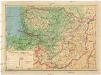
Ethnographische Karte von Litauen
1 : 2000000 Litauen Ethnische Gruppe Kettler, Julius Iwan (red.)