Maps of Landkreis Trier-Saarburg

[31] Sect. Trier, uit: Geologische Karte der Rheinprovinz und der Provinz Westphalen / ausgeführt durch H. von Dechen
1 : 80000 titelvariant: Dechen's geologische Karte vom Rheinland und Westphalen; Annotatie: Titel op bladoverzicht; Incompleet Heinrich von Dechen Berlin : Schropp
149. Trier, uit: Topographische Uebersichtskarte des Deutschen Reiches / herausgegeben v. d. Kartogr. Abt. d. Königl. Preuß. Landesaufnahme
1 : 200000 titelvariant: Topogr. Übersichtskarte des Deutschen Reiches; Annotatie: Titel boven bladen ook: Topogr. Übersichtskarte des Deutschen Reiches; Annotatie geografische gegevens: Op elk blad twee maatstokken: 10 Kilometer = 5,5 cm; 1 geogr. Meile = 3,6 cm; Legenda onder op elk blad Königlich Preußische Landesaufnahme. Kartographische Abtheilung [S.l : Königlich Preußische Landesaufnahme, Kartographische Abtheilung]
198 Birkenfeld, uit: Topographische Special-Karte von Deutschland (von Central-Europa) / begründet von D.G. Reymann ; [entworfen und gezeichn. von Heinrich Berghaus... [et al.]]
1 : 200000 Annotatie: Lit.: Daniel Gottlob Reymann und die "Topographische Special-Karte von Deutschland" / von Wolfgang Scharfe, in: Kartographische Nachrichten, 39 (1989), Heft I, p. 1-10; Handgeschreven titel: Reymann's Deutschland : 24 Sectionen: Jena, Penig, Dresden, Zittau, Hirschberg, Breslau, Brieg, Andernach, Coblenz, Giessen, Fulda, Schleusingen, Plauen, Zwickau, Teplitz, Jung Bunzlau, Hohenelbe, Glatz, Neisse, Simmern, Prag, Luxemburg, Birkenfeld; Aanwezig: 23 bladen Reymann, Daniel Gottlob; Berghaus, Heinrich [Berlin : 2. Departement des Kriegsministeriums, Bureau für Plan- und Kartenzeichnung]
Le Flambeau de la Guerre Allumee au Rhin
Mollova mapová sbírka Delisle, Guillaume Schenk, Peter II
Atlas zu der geognostischen Beschreibung des Landes, zwischen der untern Saar und dem Rheine
1 : 100000 Nordwest-Blatt Steininger, Johann Verlag der Lintz'schen Buchhandlung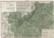
Ordre de Bataille
1 : 95000 Mollova mapová sbírka Homann, Johann Baptist Homann, Johann Baptista - dědici
Meßtischblatt 6409 : Freisen, 1940
1 : 250000 Freisen. - Aufn. 1905, hrsg. 1907, bericht. 1936, letzte Na. - 1:25000. - [Berlin]: Reichsamt für Landesaufnahme, 1940. - 1 Kt.
Meßtischblatt 6408 : Nohfelden, 1939
1 : 250000 Nohfelden. - Aufn. 1905, hrsg. 1908, bericht. 1936. - 1:25000. - [Berlin]: Reichsamt für Landesaufnahme, 1939. - 1 Kt.
Meßtischblatt 3512 : Wadern, 1933
1 : 250000 Wadern. - Hrsg. 1907, bericht. 1929, einz. Nachtr. 1933. - 1:25000. - [Berlin]: Reichsamt für Landesaufnahme, 1933. - 1 Kt.
Meßtischblatt 3511 : Losheim, 1887
1 : 250000 Losheim. - Aufn. 1885. - 1:25000. - [Berlin]: Reichsamt für Landesaufnahme, 1887. - 1 Kt.
Meßtischblatt 6309 : Birkenfeld (Ost), 1939
1 : 250000 Birkenfeld (Ost). - Aufn. 1905, bericht. 1936, letzte Nachtr. 1939. - 1:25000. - [Berlin]: Reichsamt für Landesaufnahme, 1939. - 1 Kt.
Meßtischblatt 3496 : Birkenfeld (West), 1937
1 : 250000 Birkenfeld (West). - Hrsg. 1907, einz. Nachtr. 1914. - 1:25000. - [Berlin]: Reichsamt für Landesaufnahme, 1937. - 1 Kt.
Meßtischblatt 3495 : Hermeskeil, 1908
1 : 250000 Hermeskeil. - Aufn. 1905. - 1:25000. - [Berlin]: Reichsamt für Landesaufnahme, 1908. - 1 Kt.
Meßtischblatt 3494 : Kell, 1887
1 : 250000 Kell. - Aufn. 1885. - 1:25000. - [Berlin]: Reichsamt für Landesaufnahme, 1887. - 1 Kt.
Meßtischblatt 6209 : Idar- Oberstein, 1940
1 : 250000 Idar- Oberstein. - Aufn. 1905, hrsg. 1907, bericht. 1936, letzte Na. - 1:25000. - [Berlin]: Reichsamt für Landesaufnahme, 1940. - 1 Kt.
Meßtischblatt 6208 : Morscheid, 1945
1 : 250000 Morscheid. - Aufn. 1905, hrsg. 1933, bericht. 1936, letzte Na. - 1:25000. - [Berlin]: Reichsamt für Landesaufnahme, 1945. - 1 Kt.
Meßtischblatt 6207 : Beuren, 1936
1 : 250000 Beuren. - Aufn. 1904, [hrsg. 1906], bericht. 1936. - 1:25000. - [Berlin]: Reichsamt für Landesaufnahme, 1936. - 1 Kt.
Meßtischblatt 3477 : Pfalzel, 1887
1 : 250000 Pfalzel. - Aufn. 1885. - 1:25000. - [Berlin]: Reichsamt für Landesaufnahme, 1887. - 1 Kt.
Meßtischblatt 3456 : Schweich, 1887
1 : 250000 Schweich. - Aufn. 1885. - 1:25000. - [Berlin]: Reichsamt für Landesaufnahme, 1887. - 1 Kt.
Meßtischblatt 3457 : Neumagen, 1934
1 : 250000 Neumagen. - Hrsg. 1886, bericht. 1909, einz. Nachtr. 1914, gedr. [19]34. - 1:25000. - [Berlin]: Reichsamt für Landesaufnahme, 1934. - 1 Kt.
Meßtischblatt 3457 : Neumagen, 1886
1 : 250000 Neumagen. - Aufn. 1885. - 1:25000. - [Berlin]: Reichsamt für Landesaufnahme, 1886. - 1 Kt.
Meßtischblatt 3458 : Morbach, 1886
1 : 250000 Morbach. - Aufn. 1885. - 1:25000. - [Berlin]: Reichsamt für Landesaufnahme, 1886. - 1 Kt.
Meßtischblatt 3459 : Hottenbach, 1886
1 : 250000 Hottenbach. - Aufn. 1885. - 1:25000. - [Berlin]: Reichsamt für Landesaufnahme, 1886. - 1 Kt.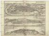
Typvs ac sitvs antiqvissimae et praecipvae mediomatricvm civitatis Trevirensis
Koblenz (Německo) Braun, Georg Hogenberg, Franz
Plan de la ville et des nouveaux ouvrages de Treves
Trier (Německo) Call, Jan van Beek, Anna Anna Beek
TREVERIS ad Mosellam, Metropolie et Sedes Archi-Episcopi et Electoris ejusdem, olim an[ti]qvitate et Claritudine praecipua
Mosela, řeka Seutter, Matthäus bey M. Seutter
Treveris ad Mosellam, metropolis et sedes archi-episcopi et electoris eiusdem olim antiquitate et claritudine praecipua
Trier (Německo) Seutter, Matthäus Adrichem, Christiaan van M. Seutter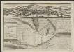
Plan de la ville et des nouveaux ouvrages de Trèves
J. van Call fecit A La Haye : chez Anna Beek
Vallentz
Mollova mapová sbírka Merian, Matthaeus Merian, Matthäus
![[31] Sect. Trier, uit: Geologische Karte der Rheinprovinz und der Provinz Westphalen / ausgeführt durch H. von Dechen](https://images-2.georeferencer.com/images/iiif/753583640597/full/,300/0/native.jpg)

