Maps of Landkreis Bernkastel-Wittlich

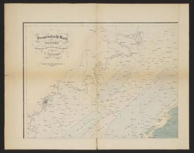
Atlas zu der geognostischen Beschreibung des Landes, zwischen der untern Saar und dem Rheine
1 : 100000 Nordwest-Blatt Steininger, Johann Verlag der Lintz'schen Buchhandlung
[31] Sect. Trier, uit: Geologische Karte der Rheinprovinz und der Provinz Westphalen / ausgeführt durch H. von Dechen
1 : 80000 titelvariant: Dechen's geologische Karte vom Rheinland und Westphalen; Annotatie: Titel op bladoverzicht; Incompleet Heinrich von Dechen Berlin : Schropp
Ordre de Bataille
1 : 95000 Mollova mapová sbírka Homann, Johann Baptist Homann, Johann Baptista - dědici
Trier mit dero Gegend auff 2 Stunden.
1 : 140000 Mollova mapová sbírka Bodenehr, Gabriel Bodenehr, Gabriel
Montroyal Sambt der Gegend auff 2 Stund.
1 : 150000 Mollova mapová sbírka Bodenehr, Gabriel Bodenehr, Gabriel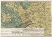
Ein Theil des Hundsrucks mit den angraenzenden Maynz u. Trierischen Laendern :
1 : 95000 Mollova mapová sbírka Homann, Johann Baptist Homann, Johann Baptista - dědici
Meßtischblatt 6208 : Morscheid, 1945
1 : 250000 Morscheid. - Aufn. 1905, hrsg. 1933, bericht. 1936, letzte Na. - 1:25000. - [Berlin]: Reichsamt für Landesaufnahme, 1945. - 1 Kt.
Meßtischblatt 6207 : Beuren, 1936
1 : 250000 Beuren. - Aufn. 1904, [hrsg. 1906], bericht. 1936. - 1:25000. - [Berlin]: Reichsamt für Landesaufnahme, 1936. - 1 Kt.
Meßtischblatt 3477 : Pfalzel, 1887
1 : 250000 Pfalzel. - Aufn. 1885. - 1:25000. - [Berlin]: Reichsamt für Landesaufnahme, 1887. - 1 Kt.
Meßtischblatt 3458 : Morbach, 1886
1 : 250000 Morbach. - Aufn. 1885. - 1:25000. - [Berlin]: Reichsamt für Landesaufnahme, 1886. - 1 Kt.
Meßtischblatt 3457 : Neumagen, 1934
1 : 250000 Neumagen. - Hrsg. 1886, bericht. 1909, einz. Nachtr. 1914, gedr. [19]34. - 1:25000. - [Berlin]: Reichsamt für Landesaufnahme, 1934. - 1 Kt.
Meßtischblatt 3457 : Neumagen, 1886
1 : 250000 Neumagen. - Aufn. 1885. - 1:25000. - [Berlin]: Reichsamt für Landesaufnahme, 1886. - 1 Kt.
Meßtischblatt 3456 : Schweich, 1887
1 : 250000 Schweich. - Aufn. 1885. - 1:25000. - [Berlin]: Reichsamt für Landesaufnahme, 1887. - 1 Kt.
Meßtischblatt 3431 : Bernkastel, 1914
1 : 250000 Bernkastel. - Aufn. 1885, hrsg. 1887, gedr. [19]14. - 1:25000. - [Berlin]: Kgl. Preuß. Landesaufnahme, 1914. - 1 Kt.
Meßtischblatt 3431 : Bernkastel, 1914
1 : 250000 Bernkastel. - Aufn. 1885, hrsg. 1887, gedr. [19]14. - 1:25000. - [Berlin]: Preuß. Landesaufnahme, 1914. - 1 Kt.
Meßtischblatt 3430 : Wittlich, 1887
1 : 250000 Wittlich. - Aufn. 1885. - 1:25000. - [Berlin]: Kgl. Preuss. Landesaufnahme, 1887. - 1 Kt.
Meßtischblatt 3429 : Landscheid, 1887
1 : 250000 Landscheid. - Aufn. 1885. - 1:25000. - [Berlin]: Kgl. Preuss. Landesaufnahme, 1887. - 1 Kt.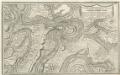
Montroyal Und Umliegende Gegend in Grund.
1 : 55000 Mollova mapová sbírka Bodenehr, Gabriel Bodenehr, Gabriel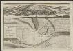
Plan de la ville et des nouveaux ouvrages de Trèves
J. van Call fecit A La Haye : chez Anna Beek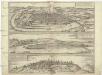
Typvs ac sitvs antiqvissimae et praecipvae mediomatricvm civitatis Trevirensis
Koblenz (Německo) Braun, Georg Hogenberg, Franz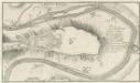
Mont-royal
Mollova mapová sbírka Bodenehr, Gabriel Bodenehr, Gabriel
Meßtischblatt 6209 : Idar- Oberstein, 1940
1 : 250000 Idar- Oberstein. - Aufn. 1905, hrsg. 1907, bericht. 1936, letzte Na. - 1:25000. - [Berlin]: Reichsamt für Landesaufnahme, 1940. - 1 Kt.
Meßtischblatt 3459 : Hottenbach, 1886
1 : 250000 Hottenbach. - Aufn. 1885. - 1:25000. - [Berlin]: Reichsamt für Landesaufnahme, 1886. - 1 Kt.
Meßtischblatt 3432 : Sohren, 1914
1 : 250000 Sohren. - Hrsg. 1886, N[achtr. 19]14. - 1:25000. - [Berlin]: Preuss. Landesaufnahme, 1914. - 1 Kt.
Meßtischblatt 3432 : Sohren, 1909
1 : 250000 Sohren. - Aufn. 1885, hrsg. 1886, bericht. 1909. - 1:25000. - [Berlin]: Kgl. Preuss. Landesaufnahme, 1909. - 1 Kt.
Meßtischblatt 3432 : Sohren, 1886
1 : 250000 Sohren. - Aufn. 1885, hrsg. 1886. - 1:25000. - [Berlin]: Kgl. Preuss. Landesaufnahme, 1886. - 1 Kt.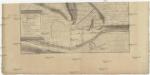
Plan de la ville et des nouveaux ouvrages de Treves
Trier (Německo) Call, Jan van Beek, Anna Anna Beek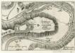
Letzte Delineation der Vestung Mont-Royal Ai. 1693.
1 : 20000 Mollova mapová sbírka Person, Nikolaus Person, Nicolas
TREVERIS ad Mosellam, Metropolie et Sedes Archi-Episcopi et Electoris ejusdem, olim an[ti]qvitate et Claritudine praecipua
Mosela, řeka Seutter, Matthäus bey M. Seutter