Maps of Poland

Oorlogskaart van Polen : bijzonder geschikt voor het volgen van de internationale gebeurtenissen / [cartografie] W. Seghers
1 : 1111000 W. Seghers Antwerpen : Patria ; [etc.]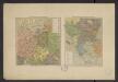
Atlas Niox ; Atlas Niox. No. 31, Populations de l'Europe centrale. No. 31 bis, Populations de la péninsule des Balkans
1 : 6000000 Niox, Gustave-Léon 1840-1921 Paris : Ch. Delagrave
Mapa narodowościowa ziem Polskich
1 : 2000000 Evropa východní Maliszewski, Edward wydawnictwo Biura Pracy Spolecznej
Polonia
Polsko
Herzogthum Warschau 1808
1 : 20000000 Herzogtum Warschau
Herzogthum Warschau 1810
1 : 20000000 Herzogtum Warschau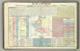
Tableau l'historie des Royaumes de Pologne, de Boheme et de Hongrie.
1 : 6800000 Duval, Henri
Regnum Poloniae eiusque confinia
1 : 11100000 1 Karte : Kupferdruck ; 13 x 17 cm Weigel, Johann Christoph [Johann Christoph Weigel]
Reise Charte durch das Königreich Polen mit allen darzu gehörigen Laendern / verfertiget von JG. S
1 : 9300000 1 Karte : Kupferdruck ; 16 x 21 cm, Bildgr. 17 x 25 cm Schreiber, Johann Georg [J. G. Schreiber]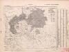
Poland: Germans and White Russians
1 : 3000000 Series of maps on various aspects of Poland. Poland. Germans and White Russians. Distribution of Germans and White Russians, showing minorities War Office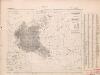
Poland: Poles
1 : 3000000 Series of maps on various aspects of Poland. Distribution of Poles showing minorities. War Office
Ostmitteleuropa 1949
Ostmitteleuropa Kunz, Andreas ; Treiling, Thomas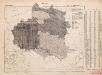
Poland: Language. No.2
1 : 3000000 Series of maps on various aspects of Poland. Distribution of languages according to various authorities. War Office
Poland: Jews
1 : 3000000 Series of maps on various aspects of Poland. Distribution of Jewish minorities. War Office
Poland: Lithuanians, Little Russians and Czechs
1 : 3000000 Series of maps on various aspects of Poland. Distribution of Lithuanians, Little Russians and Czechs, showing minorities. War Office
Poland: Language. No.1
1 : 3000000 Series of maps on various aspects of Poland. Languages in 1910-1913. War Office
Mapa rozmieszczenia gleb na ziemiach polskich
1 : 6300000 Polen Geologie Arct, Michał
Polska za Mieczyslawa I
Polsko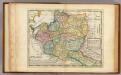
Poland.
1 : 6300000 Moll, Herman, d. 1732
Die Teilungen Polens
1 : 15000000 Polen Teilungen Polens
Poland: Poles (excluding Jews)
1 : 3000000 Series of maps on various aspects of Poland. Poles (excluding Jews). Kingdom of Poland (1897) an Galicia (1900). Distribution of Poles, showing minorities. War Office
Die Teilungen Polens
1 : 10000000 Polen-Litauen Teilungen Polens
Carte des partages de la Pologne en 1772, 1793 et 1795
1 Karte : Typometrie ; 24 x 28 cm Haas chez G. Haas et chez J. Decker imprimeur libraire =Johann Heinrich Deckers Erben?
Carte des partages de la Pologne en 1772, 1793 et 1795
1 Karte : Typometrie ; 24 x 28 cm Haas chez G. Haas et chez J. Decker imprimeur libraire =Johann Heinrich Deckers Erben?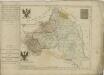

Poland: Density
1 : 3000000 Series of maps on various aspects of Poland. Density. Number of inhabitants per square kilometre. War Office
Mapa rozmieszczenia bogactw kopalnych na ziemiach polskich
1 : 6300000 Polen Geologie Arct, Michał
Eastern Germany, distribution of population.
1 : 2400000 Covers Poland, East Prussia, and border areas of Germany and Czechoslovakia. "From: Atlas des deutschen Lebensraumes in Mitteleuropa, plate 27. Data as of 1930-1934." "No. A-6287." United States. Office of Strategic Services. Research and Analysis Branch. [Washington, D.C.] : R & A, OSS
Karpathenlaender, Polen und Preussen
E. von Sydow's Schul-Atlas in sechs und dreissig Karten Sydow, Emil von bei Justus Perthes
![Oorlogskaart van Polen : bijzonder geschikt voor het volgen van de internationale gebeurtenissen / [cartografie] W. Seghers](https://images-2.georeferencer.com/images/iiif/161798857987/full/,300/0/native.jpg)

