Maps of Poland

Carte des partages de la Pologne en 1772, 1793 et 1795
1 Karte : Typometrie ; 24 x 28 cm Haas chez G. Haas et chez J. Decker imprimeur libraire =Johann Heinrich Deckers Erben?
Carte des partages de la Pologne en 1772, 1793 et 1795
1 Karte : Typometrie ; 24 x 28 cm Haas chez G. Haas et chez J. Decker imprimeur libraire =Johann Heinrich Deckers Erben?
Die Republik Polen nach ihrem Bestande im Jahre 1772 und das Königreich Polen seit dem Jahre 1815
1 : 5890000 Polsko Kleinknecht
Polen nach der Theilung im Jahre 1815, 1793, 1795 ; Die Theilung von Polen im Jahre 1772
Polsko
Mapa rozmieszczenia gleb na ziemiach polskich
1 : 6300000 Polen Geologie Arct, Michał
Mapa rozmieszczenia bogactw kopalnych na ziemiach polskich
1 : 6300000 Polen Geologie Arct, Michał
Mappa Polski i krajow okolicznych
1 : 3810000 Evropa východní Sławinski, J.
Poland, Prussia.
1 : 2400000 Robert Laurie & James Whittle
Poloniae Regnum ut et Magni Ducat. Lithuaniae
1 : 8500000 Mollova mapová sbírka Dorn, Sebastian Raspe, Gabriel Nikolaus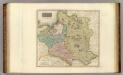
Poland.
1 : 2500000 Thomson, John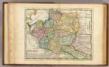
Poland.
1 : 6300000 Moll, Herman, d. 1732
Herzogthum Warschau 1808
1 : 20000000 Herzogtum Warschau
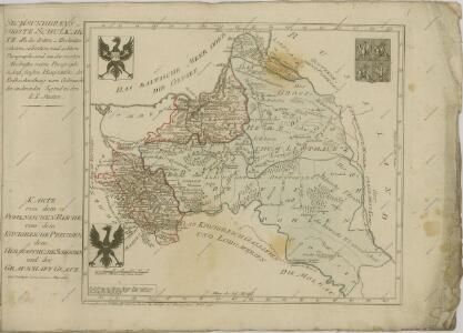
Karte von Polen
1 : 1900000 Bělorusko Reilly, Franz Johann Josef von Amon, Anton von Franz Ioh. Ios. von Reilly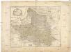
Karte von Polen
1 : 1900000 Bělorusko Reilly, Franz Johann Josef von Amon, Anton Franz Ioh. Ios. von Reilly
Poland: Language. No.1
1 : 3000000 Series of maps on various aspects of Poland. Languages in 1910-1913. War Office
Poland: Poles
1 : 3000000 Series of maps on various aspects of Poland. Distribution of Poles showing minorities. War Office
Partitions of Poland. 1918
1 : 4000000 Partitions of Poland. 1918. Partitions of 1772, 1793, 1795. Russia, Prussia, Austria. War Office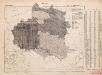
Poland: Language. No.2
1 : 3000000 Series of maps on various aspects of Poland. Distribution of languages according to various authorities. War Office
Poland: Jews
1 : 3000000 Series of maps on various aspects of Poland. Distribution of Jewish minorities. War Office
Karte von Polen
1 : 1900000 Bělorusko Amon, Anton von Franz Ioh. Ios. von Reilly
Theilung 1772 ; Theilung 1793 ; Theilung 1795 ; Polen 1812, Theilung 1815
Polsko
Poland: Poles (excluding Jews)
1 : 3000000 Series of maps on various aspects of Poland. Poles (excluding Jews). Kingdom of Poland (1897) an Galicia (1900). Distribution of Poles, showing minorities. War Office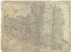
Das Königreich Polen nebst den angränzenden Ländern
1 : 1910000 Polsko Sotzmann, Daniel Friedrich im Verlag der Schneider u. Weigelschen Kunst- und Buchhandlung
Mapa narodowościowa ziem Polskich
1 : 2000000 Evropa východní Maliszewski, Edward wydawnictwo Biura Pracy Spolecznej
Poland: Lithuanians, Little Russians and Czechs
1 : 3000000 Series of maps on various aspects of Poland. Distribution of Lithuanians, Little Russians and Czechs, showing minorities. War Office
[Historisch-geographischer Atlas zu den allgemeinen Geschichtswerken von C. v. Rotteck, Pölitz u. Becker] : Polen von dem Aussterben der Jagellonen bis zur dritten Theilung; von 1572 bis 1795
von Julius Loewenberg Lithographie von B. Herder in Freiburg im Breisgau 1836 [Freiburg im Breisgau] : [Herder]
Mappa geographica, ex novissimis observationibus repraesentans regnum Poloniae et magnum ducatum Lithuaniae
1 : 2700000 Bělorusko Lotter, Tobias Conrad
Mappa geographica, ex novissimis observationibus repraesentans regnum Poloniae et magnum ducatum Lithuaniae
1 : 2700000 Bělorusko Lotter, Tobias Conrad sumptibus Tobiae Conradi Lotter
Mappa geographica, ex novissimis observationibus repraesentans regnum Poloniae et magnum ducatum Lithuaniae
1 : 2700000 Bělorusko Lotter, Tobias Conrad sumptibus Tobiae Conradi Lotter
Mappa geographica, ex novissimis observationibus repraesentans regnum Poloniae et magnum ducatum Lithuaniae
1 : 2700000 Bělorusko Lotter, Tobias Conrad sumptibus Tobiae Conradi Lotter