Maps of Western Australia

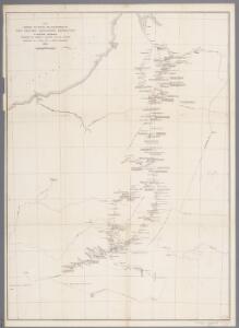
Map shewing the route and discoveries of the Calvert Exploring Expedition in Western Australia : equipped by Albert F. Calvert F.R.G.S. London, commanded by L.A. Wells of S.A. Survey Department, 1896-7 / comp. by L.A. Wells ; drawn by W.F.H.
1 : 1500000 Annotatie: Vermoedelijk afkomstig uit: Journal of the Calvert Scientific Exploring Expedition, 1896-7 ... - Perth : Watson, 1902 Wells, L. A.; W. F. H. [S.l. : s.n.]
La presqu'isle de l'Indie au dela du Gange, avec l'archipel des Indes
1 : 12640000 Asie jihovýchodní Bonne, Rigobert André
Western Australia.
1 : 4088064 Stanford, Edward
Australia - western section.
1 : 6000000 John Bartholomew & Co.
Map of Western Australia, 1904
1 : 4680000 Západní Austrálie H.J. Petcher
Map of Western Australia : shewing pastoral leases in green, the total area of which is 96,508,549 acres, to accompany Annual report for 1901
1 : 3200000 [S.l. : s.n.]
Australia.
1 : 5068800 Arrowsmith, John
Nieuwe kaart van de Filippynsche, Ladrones, Moluccos of Specery Eilanden alsmede Celebes enz. / uitgegeven te Amsterdam door Isaak Tirion
Te Amsterdam : door Isaak Tirion
Blad VII Siding, uit: Residentie Wester-Afdeeling van Borneo / Topographisch Bureau
1 : 200000 titelvariant: Residentie Westerafdeeling van Borneo; Annotatie: Titelvariant: Residentie Westerafdeeling van Borneo; Voor aanwezige bladen zie overzichtsblad; Annotatie geografische gegevens: Opname: 1886-1895 Topographisch Bureau, Batavia Batavia : Topographisch Bureau
Progressus numericus Catholicorum ab anno 1938 usque ad annum 1948, necnon distributio Catholicorum tempore dismembrationum anno 1938 et 1948, grafice exhibitur in Insulæ Borneo parte Indonesiana
1 : 16500000 [S.l. : Vicario Apostolico de Pontianak]
Carte des îles Philippines, Célébes et Moluques
1 : 3700000 dressée par M. Daussy d'après les travaux le plus récents gravé par Chassant ; écrit par J.M. Hacq. [Paris] : Dépot-général de la Marine
Neu-Seeland
Adolf Stieler's Handatlas über alle Theile der Erde und über das Weltgebäude Stieler, Adolf Justus Perthes
Celebes, de Kleine Soenda-Eilanden / Geogr[aphische] lithogr[aphie] v[an] E. de Geest
Seyffardt's Boekhandel Amsterdam Amsterdam : Lith[ographische] Drukkerij van Seyffardt's Boekhandel te Amsterdam
West-Australien. Tasmania. Neu-Seeland. Der Isthmus Von Auckland.
1 : 5000000 Petermann, A.
Algemeene schetskaart van Nederlandsch-Indië : Gouv[ernement] Groote Oost, Res[identie] Manado / Topografische Dienst, Batavia
[S.l. : s.n.]
[West-Australien, Tasmania früher genannt Van Diemen's Land, Neu-Seeland]
Hand-Atlas über alle Theile der Erde und über das Weltgebäude Stieler, Adolf Justus Perthes
Islas Filipinas, 3a hoja / por el teniente coronel de ingenieros D. Francisco Coello ; las notas estadisticas e historicas han sido escritas por D. Pascual Madoz
1 : 1000000 1 full d'un mapa en tres fulls, b/n. Dins: Atlas de España y sus posesiones de ultramar Coello, Francisco ; Madoz, Pascual [Imprenta del Atlas de España]
Kaart van het eiland Celebes
D. Heyse lith. te 's Hage ; steendr. v. P. Blommers te 's Hage te 's Hage : uitgave van K. Fuhri
Blad VIII Tajan, blad f, uit: Residentie Wester-Afdeeling van Borneo : weg- en rivierkaart / Topographisch Bureau
1 : 50000 Annotatie: Voor aanwezige bladen zie overzichtsblad Topographisch Bureau, Batavia Batavia : Topographisch Bureau
REDUZIRTE-KARTE VON DEN PHILIPPINEN und den SULU INSELN
1 : 2400000 Filipíny Berghaus, Heinrich Karl Wilhelm Aragon, Ildefonso de Justus Perthes
No. 6. Distibucion de Temlores Signos.
1 : 6000000 U.S. Coast and Geodetic Survey
Reduzirte Karte von den Philippinen und den Sulu-Inseln
1 : 2356000 den Manen Don Alexandro ́s Malaspina, Espinosa y Tello's, [...] Don Ildefonso de Aragon gewidmet vom Verfasser [H. Berghaus] gest. v. Selmar Siebert Gotha : Perthes
Bladwijzer Zuider en ooster afd. van Borneo
[S.l. : s.n.]
Mapa de las yslas Philipinas
1 : 3100000
[Borneo, Celebes, Halmaheira, Ceram] / Top. Bureau v/d Gen. Staf
Topographisch Bureau Generale Staf Batavia Batavia : Top. Bureau v/d Gen. Staf
Philippines.
1 : 2280000 Rand McNally and Company
Philippine Islands.
1 : 2471000 Rand McNally and Company
Chart of the Philippine Islands, from the Spanish chart in 1808, the adjacent islands are added from the lastest surveys
1 : 1660000 Arrowsmith, Arron Arrowsmith, Aaron
Carta particolare dell'Isole Fillipine è di Luzon
1 : 2000000