Maps of South Holland

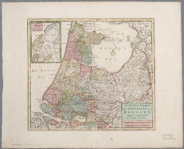
Nieuwe kaart der provincie van Holland
1 : 450000 Annotatie: Oorspronkelijk verschenen in: Hedendaegsche historie, of Tegenwoordige staet van alle volkeren / Jan Wagenaar, dl. XIV. - Amsterdam : Isaak Tirion, 1742; Ook verschenen in: Nieuwe handatlas ... - Amsterdam : Isaak Tirion, 1744, of latere editie Te Amsterdam : by Isaak Tirion
Kaart van ’t Graafschap Holland naauwkeurig afgedeelt in zyne heemraadschappen, baljuwschappen en waarden, nevens verscheide andere minder afdeelingen en onderhorige landen als mede van de Heerlykheit Utrecht en het grootste gedeelte van Gelderlandt = Hollandiae Comitatus una cum Ultrajectino Dominio nec non maximis partibus Geldriae Ducatus
1 : 310000 per C. Specht. Te Amsterdam : by Reinier en Josua Ottens
Kaart van 't Graafschap Holland naauwkeurig afgedeelt in zyne heemraadschappen, baljuwschappen en waarden, nevens verscheide andere minder afdeelingen en onderhorige landen als mede van de Heerlykheit Utrecht en het grootste gedeelte van Gelderlandt
1 : 310000 per C. Specht. Te Amsterdam : by Reinier en Josua Ottens ...
Tabula Comitatus Hollandiæ in præfecturas suas distributa; cui adjuncta est provinc. Ultraiectina et maxima pars Geldriæ
1 : 310000 sum(m)o studio delin. et aeri incidit Matthaeus Seutter. Aug[sburg] : [Matthæus Seutter]
Kaart van't Graafschap Holland Naauwkeurig afgedeelt in zyne Heemraadschappen, Baljuwschappen en Waarden nevens verscheide andere minder afdeelingen en onderhorige landen als mede van de Heerlykheit Utrecht en het grootste gedeelte van Gelderlandt
1 : 300000 Mollova mapová sbírka Specht, Caspar Ottens, Josua
Tabula Comitatus Hollandiæ in præfecturas suas distributa; cui adjuncta est provinc. Ultraiectina et maxima pars Geldriæ
1 : 310000 sum[m]o studio delin. et aeri incidit Johan Michael Probst, geogr. et calcogr., renovatus. Aug[usta Vindelicorum]
'T Graavschap Holland en Sticht van Utrecht nevens de voornaamste delen van Gelderland in haar minder verdeling op niews verbetert
1 : 310000 per C. Specht. T'Utrecht : door Caspar Specht
Nieuwe kaart der provincie van Holland
1 : 440000 [Jacob Keizer designer and engraver] Amsterdam : by Isaak Tirion
Particuliere description du Conte d'Hollande, et pais d'Utrecht
1 : 650000 [Lodovico Guicciardini] [engraver: Corneel Muller] [Antwerpen] : [Willem Silvius]
Carte generale des IX de la Hollande; avec la Seig. d'Utrecht, Par.tie de la Gueldre, &c.
1 : 850000 [Guillaume Delahaye engraver] [Paris ] : par le sr. Robert, géog[raphe] du roi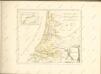

Carte generale des IX de la Hollande; avec la Seig. d'Utrecht, Par.tie de la Gueldre, &c.
1 : 850000 [Guillaume Delahaye engraver] [Paris] : par le sr. Robert, géogr. du roi
Waterstaatkundige kaart der hoofdrivieren in de noordelijke provincien van het Koningrijk der Nederlanden : van den onverdeelden Boven Rijn tot in de Noord en Zuider Zeeën : ter verklaring van de ontwerpen, zoo der afleidings en militaire inundatie sluizen, als betrekkelijk de overlaten door de landen van Altena
1 : 120000 door J. Blanken Jansz. steendr. van Houtman, te Utrecht. Amsterdam : Waterstaat en publieke werken
Nuova carta della contea di Olanda
1 : 700000 Frano. Sesone sculp. [Napoli] : [Francesco Ricciardo]
Netherlands.
1 : 1180000 Lucas, Fielding Jr.
Nuova carta della contèa di Olanda
1 : 700000 [Giambatista Albrizzi] [Venezia] : [Giambatista Albrizzi]
Hollandiae chorographia
1 : 750000 [Jodocus Hondius sr.] [Amsterdam] : [Jodocus Hondius sr.]
Holland
1 : 800000 [Franz Johann Joseph von Reilly] [Wien] : [Franz Johann Joseph von Reilly]
Comitatus Hollandiæ tabula pluribus locis recens
1 : 300000 pluribus locis recens emendata a Nicolao Visscher. [Amsterdam] : nunc apud Petrum Schenk junior
Comitatus Hollandiae tabula / pluribus locis recens emendata a Nicolao I. Visschero
1 : 300000 Annotatie: Origineel is Blad 50 in atlas factice; Annotatie geografische gegevens: West boven Visscher, Claes Jansz. [Amsterdam : C.J. Visscher excudit]
Comitatus Hollandiæ tabula pluribus locis recens
1 : 320000 pluribus locis recens emendata a Justo Danckerts. [Amsterdam] : Justus Danckerts
Comitatus Hollandiae tabula
1 : 300000 pluribus locis recens emendata a Frederico de Wit. [Amsterdam] : ex officina I. C
Comitatus Hollandiæ tabula pluribus locis recens
1 : 300000 pluribus locis recens emendata a Frederico de Wit. Gedruckt 't Amsterdam : by Frederick de Wit ...
Comitatus Hollandia = ’t Graefschap Hollandt
1 : 400000 van nieus verb. ende verm. door Willem Janszoon [Blaeu] Josua vanden Ende sculpsit. Amsterdam : ghedruckt bij Willem Jansz. op 't water inde Sonnewijser
Comitatus Hollandiæ tabula pluribus locis recens
1 : 300000 pluribus locis recens emendata a Francisco Caroli J. Bormeester. eccu. Amstel' : Petrum Schenk exc.
Hollandia Comitatus
1 : 550000 [Willem Jansz. Blaeu] Josua vanden Ende sculpsit. T'Amsterdami : by Rombout van den Hoeye
Condado de Olanda
1 : 1000000 [Jacques Harrewijn] [Madrid] : [Francisco Laso]
Comitatus Hollandiae Tabula Pluribus Locis [...] [Karte], in: Novus atlas absolutissimus, Bd. 3, S. 162.
1 Karte aus Atlas Janssonius Offizin
Hollandiæ Comitatus in ejusdem subjacentes ditiones; una cum toto Ultrajectino Dominio, nec non maximis partibus Geldriæ Ducatus, Frisiæ Comitatus, aliarumq[ue] vicinarum provinciarum foederatarum; exactissimè delineatus
1 : 300000 per Nicolaum Visscher ... G. Gouwen schulp. t' Amsteldam : door Nicolaus Visscher [II]