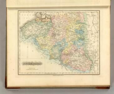
Maps of Gelderland

Netherlands.
1 : 1180000 Lucas, Fielding Jr.
Exactissima Belgii Foederati Tabula cum annexis divisa in Provincias
1 : 250000 Mollova mapová sbírka Specht, Caspar Ottens, Josua
De VII Vereenigde Nederlandsche Provinciën
1 : 250000 naar de nieuwste meetingen naauwkeurig geteekend en in 't koper gebragt door Christiaan Sepp en Zoon. Te Amsterdam : by J.C. Sepp
Belgii pars septentrionalis communi nomine vulgo Hollandia nuncupata continens statum potentissimae Batavorum reipublicae sev provincias VII foederatas
1 : 630000 Belgie Homann, Johann Baptist exhibente Io. Baptista Homanno
Belgii pars septentrionalis communi nomine vulgo Hollandia nuncupata continens statum potentissimae Batavorum reipublicae sev provincias VII foederatas
1 : 630000 Belgie Homann, Johann Baptist exhibente Io. Baptista Homanno
De VII. Vereenigde Nederlandsche Provincien

Kaart der Bataafse Republiek : verdeeld in departementen en ringen volgens de acte van staatsregeling bij publicatie van het Uitvoerend Bewind van den 17 Novemb. 1798 en in districten bij publicatie van den 14 Meij 1799
1 : 2000000 door Quint Ondaatje C. van Baarsel sculp[sit] Amst. In de Haag : bij J.C. Leeuwensteijn
[Nizozemsko]
Nizozemsko
Holland.
1 : 520000 Pinkerton, John, 1758-1826
Kaart van het Koningrijk der Nederlanden : aantoonende de wijze waarop en de plaatsen waarheen op 1e September 1856 briefpakketten worden verzonden of briefbestelling wordt verrigt op kosten van 's Rijks schatkist, benevens opgave waar op dat tijdstip E.M. telegraaf kantoren geopend waren
1 : 550000 ontworpen en geteekend door S. Gille Heringa op steen gebragt bij A.J. Bogaerts. Middelburg : J.G. en W. Altorffer
Kaart van het Koningrijk der Nederlanden : aantoonende de wijze waarop en de plaatsen waarheen op 1e Januarij 1857 briefpakketten worden verzonden of briefbestelling wordt verrigt op kosten van 's Rijks schatkist, benevens opgave waar op dat tijdstip E.M. telegraaf kantoren geopend waren
1 : 550000 ontworpen en geteekend door S. Gille Heringa op steen gebragt bij A.J. Bogaerts. Middelburg : J.G. en W. Altorffer
De zeeven Neederlanden.
1 : 800000 [François Halma] [Leeuwarden] : [Hendrik Halma]
Nieuwe kaart der Vereenigde Nederlanden.
1 : 1000000 Te Amsterdam : by Isaak Tirion
Particuliere description du Conte d'Hollande, et pais d'Utrecht
1 : 650000 [Lodovico Guicciardini] [engraver: Corneel Muller] [Antwerpen] : [Willem Silvius]
Nieuwe kaart van Holland
1 : 675000 J.C. de Roeder, delin. H. Klockhoff, dir. sculp. 1792. [Amsterdam] : [Johannes Allart]
Netherlands.
1 : 690000 Lizars, Daniel
Nieuwe kaart van Holland tot het Vaderlandsch Woordenboek van Kok behoorende
1 : 675000 J.C. de Roeder, delin. H. Klockhoff, dir. sculp. 1792. [Amsterdam] : [Johannes Allart]
Holland
1 : 800000 [Franz Johann Joseph von Reilly] [Wien] : [Franz Johann Joseph von Reilly]
Descriptio Agri Frisii antiqui aliorumque trans Rhenum qui hodie sunt in dicione VII Foederatorum
1 : 700000 auctore Mensone Alting. [Amstelaedami] : [apud Henricum Wetstenium]
Nuova carta della contea di Olanda
1 : 700000 Frano. Sesone sculp. [Napoli] : [Francesco Ricciardo]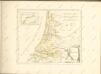

Nuova carta della contèa di Olanda
1 : 700000 [Giambatista Albrizzi] [Venezia] : [Giambatista Albrizzi]
Belgio confederato altrimenti detto l'Olanda, delineato
1 : 1200000 delineato, e descritto dal P. Coronelli. [Napoli] : [Vincenzo Coronelli]
Comitatus Hollandiae Tabula Pluribus Locis [...] [Karte], in: Novus atlas absolutissimus, Bd. 3, S. 162.
1 Karte aus Atlas Janssonius Offizin
Comitatus Hollandiæ tabula pluribus locis recens
1 : 300000 pluribus locis recens emendata a Nicolao Visscher. [Amsterdam] : nunc apud Petrum Schenk junior
Comitatus Hollandiæ novissima descriptio
1 : 360000 designatore Balthazaro Florentio a Berckenrode Salomon Rogiers sculpsit. Amstelodami : sumptibus Henrici Hondii ...
Comitatus Hollandiae pluribus locis recens emendata / a Frederico de Wit
1 : 300000 Annotatie: Deze derde staat van de koperplaat is te herkennen aan het cijfer "I" rechtsboven (net als de tweede staat) en aan het feit dat de plattegrond van Amsterdam is ingevuld (bij de eerste en tweede staat van de koperplaat is dit niet het geval); Annotatie geografische gegevens: West boven Wit, Frederik de Amsterdam : Frederick de Wit
Vollständige Carte des gantzen Rhein Stroms
1 : 840000 Mollova mapová sbírka Riegel, Christoph Riegel, Christoph
Charte von Holland
1 : 300000 nach astronomischen Beobachtungen, den Messungen des Schnellius &.c.c. und den vorzüglichsten Specialcharten neu entworfen von F.L. Güssefeld. Nürnberg : bey den Hom[ännischen Erben]