Maps of Ethiopia
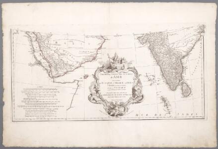
Prémière partie de la carte d'Asie : contenant la Turquie, l'Arabie, la Perse, l'Inde en deçu du Gange et de la Tartarie ce qui est limitrophe de la Perse et de l'Inde / par le Sr. d'Anville ; gravé par Guill. de-la-Haye
1 : 6650000 Annotatie: In: [Atlas du Sr. d'Anville], bl. 1 Anville, Jean Baptiste Bourguignon d'; Haye, Guill. de la A Paris : chez l'auteur
Arabian Sea.
1 : 10000000 Philip, George
Sexta Asie Tabula [Karte], in: [Clavdii Ptholomei Cosmographi ...], S. 317.
1 Karte aus Atlas Nicolaus Germanus [und Ptolemaeus, Claudius]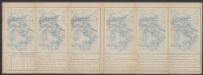
Tabula Asiae VI. [Karte], in: Claud. Ptolemaeus. Geographia lat. cum mappis [...], S. 311.
1 Karte aus Atlas Münster, Sebastian [und Ptolemaeus, Claudius]
Carte d'une partie des Indes orientales, estats du Mogol les côtes de Malabar et de Coromandel &c
1 : 14000000 Himálaj-oblast par Cóvens et Mortier
Delineatio omnium orarum totius australis partis Americae, dictae Peruvianae, a R. de la Plata, Brasiliam, Pariam, & Castellam auream, una cum omnibus insulis Antillas dictis, Hispaniolam, item & Cubam comprehendentis, usq[ue] ad promont. Floridae, vulgo cabo de la Florida, item isthmi inter Panamam & Nombre de dios, terrae Peru auriferae, cum ejus metropoli Cusco & com[m]odissimo portu Limae. orarum etiam Chilae, freti inter terram Patagonum, & terram del fuego, vulgo Estre
Jižní Amerika Langren, Arnoldus Florentius De Laet, Johannes
Carte de l'Indostan servant à indiquer les possessions françaises en Asie
1 : 10000000 par A.M. Perrot gravé par les frères Malo Paris : Duprat-Duverger
Carte Generale des Indies.
1 : 9500000 Vivien de St Martin, L.
Composite: Hindoostan.
1 : 2500000 Robert Laurie & James Whittle
Arabia.
1 : 13800000 Darton, William
Abessinien
1 : 5000000 Afrika východní Josef Ulbricht
Abyssinië in vogelvlucht gezien = Abyssinie vue a vol d'oiseau / Seghers
titelvariant: Abyssinie vue a vol d'oiseau; Annotatie: Gegevens verzameld over de periode/Data collected over the period: 1935; With photographs of current world leaders; Fragment: foto's van wereldleiders ontbreken; Annotatie geografische gegevens: Bijkaart: Van Gibraltar tot Abessinië = De Gibraltar a l'Abessinie W. Seghers Antwerpen [etc.] : [Patria, etc.]
Composite: East Indies with roads.
1 : 2600000 Jefferys, Thomas
Arabien.
1 : 5500000 Weiland, C. F. (Carl Ferdinand), d. 1847
Etiópia (Abesszínia)
1 : 5000000 Annotatie geografische gegevens: Aansluitende inzetkrt: [Socotra]; Inzetkrt.: Afrika. - 1:50.000.000. Etiópia fontosabb törzsei. - [1:20.000.000] Budapest : M. Kir. Állami Térképészet
Hindostan.
1 : 12600000 Greenleaf, Jeremiah
Hindostan.
1 : 12600000 Greenleaf, Jeremiah
Southern India Including The Presidencies Of Bombay & Madras.
1 : 9000000 Tallis, J. & F.
Arabiae Felicis, Petraeae et Desertae nova et accurata delineatio. [Karte], in: Novus atlas absolutissimus, Bd. 6, S. 102.
1 Karte aus Atlas Janssonius Offizin
Ostafrika – Vých. Afrika

Arabien, Ägypten, Nubien und Habesch
Schul-Atlas in 36 Karten Völter, Daniel Verlag der J.M. Dannheimer'schen Buchhandlung
116-17. Eritrea, Etiopia, Somalia.
1 : 5000000 Touring club italiano
Stanford's Map Of India.
1 : 2217600 Stanford, Edward

Arabia et Arabicus sinus
1 : 5700000 Arabský poloostrov Reichard, Christian Gottlieb Campius, D. a D. Campio
Spezial-Karte von Afrika
1 : 4000000 Blatt 6 Habenicht, Hermann Perthes
L'empire du Mogol, et la presqu'isle de l'Inde en deçá du Gagne
1 : 12640000 Indie Bonne, Rigobert André
[Kaart], uit: Colonie dell'Africa Orientale Italiana
1 : 4000000 Annotatie: Ondertitel op omslag: Eritrea - Somalia Italiana - Etiopia - Somalia Francese e Britannica; Annotatie geografische gegevens: Inzetkrt.: [Omgevingskaart]. - 1:50.000.000 Milano : Vallardi