Maps of Arabian Peninsula
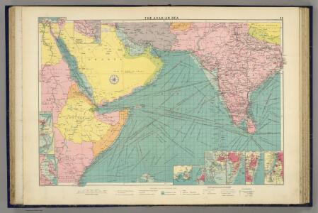
Arabian Sea.
1 : 10000000 Philip, George
Mittel- und Nord-Africa und Arabien. Östliches Blatt
Stieler's Hand-Atlas Stieler, Adolf bei Justus Perthes
Sexta Asie Tabula [Karte], in: Claudii Ptolemei viri Alexandrini mathematice discipline philosophi doctissimi geographie opus [...], S. 208.
1 Karte aus Atlas Waldseemüller, Martin [und Ptolemaeus, Claudius] Übelin, Georg
[Mittel- und Nord-Africa und Arabien, Oestliches Blatt]
Hand-Atlas über alle Theile der Erde nach dem neuesten Zustande und über das Weltgebäude Stieler, Adolf bei Justus Perthes

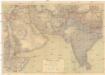
Prémière partie de la carte d'Asie : contenant la Turquie, l'Arabie, la Perse, l'Inde en deçu du Gange et de la Tartarie ce qui est limitrophe de la Perse et de l'Inde / par le Sr. d'Anville ; gravé par Guill. de-la-Haye
1 : 6650000 Annotatie: In: [Atlas du Sr. d'Anville], bl. 1 Anville, Jean Baptiste Bourguignon d'; Haye, Guill. de la A Paris : chez l'auteur
Sexta Asie Tabula [Karte], in: [Clavdii Ptholomei Cosmographi ...], S. 317.
1 Karte aus Atlas Nicolaus Germanus [und Ptolemaeus, Claudius]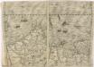
Bez titulu: Indie, Indický oceán
Südwest-Asien
1 : 5000000 Asie jihozápadní Justus Perthes
Tabula Asiae VI. [Karte], in: Geographia universalis vetus et nova complectens Claudii Ptolemaei Alexandrini enarrationis libros VIII, S. 281.
1 Karte aus Atlas Münster, Sebastian [und Ptolemaeus, Claudius]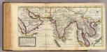
Map of the continent of the East-Indies &c
1 : 19000000 Moll, Herman, d. 1732
Erster Theil der Karte von Asien
1 : 7250000 Arabský poloostrov Anville, Jean-Baptiste Bourguinon d' Adam, Jakob F.A. Schraembl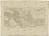
[Erster Theil der Karte von Asien]
Arabský poloostrov Anville, Jean-Baptiste Bourguinon d' Adam, Jakob F.A. Schraembl
Tabula Asiae VI. [Karte], in: Claud. Ptolemaeus. Geographia lat. cum mappis [...], S. 311.
1 Karte aus Atlas Münster, Sebastian [und Ptolemaeus, Claudius]
[Azië], uit: Routekaart van Nederland naar Ned. Indië en terug
1 : 8000000 Annotatie: Samengest. op uitnoodiging der Stoomvaart Maatschappij Nederland Groustra, J. Amsterdam : Seyffardt
Carte Particuliere De La Mer Rouge &c. Levée Par Ordre Expres des Roys de Portugal sous qui on en a Fait la Decouverte. [Karte], in: Atlas nouveau, contenant toutes les parties du monde [...], Bd. 2, S. 228.
1 Karte aus Atlas Sanson, Nicolas Jaillot, Alexis Hubert und Mortier, Pieter
[Mittel- und Nord-Africa, Oestl. Theil und Arabien]
Hand-Atlas über alle Theile der Erde und über das Weltgebäude Stieler, Adolf Justus Perthes
L'Asie 3.
1 : 9500000 Brue, Adrien Hubert, 1786-1832
Nordost-Afrika und Arabien
Handatlas über alle Theile der Erde und über das Weltgebäude Stieler, Adolf Justus Perthes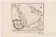
Carte de la coste d'Arabie, Mer Rouge et Golfe de Perse : tirée de la Carte de l'Océan Oriental publiée en 1740 par Ordre de Mgr le Comte de Maurepas augmentée sur des remarques particulières et dressée sur des observations astronomiques = Kaart van de Kust van Arabië, de Roode-Zee en de Gulf van Persië Gemaakt na de Fransse-Kaart van den Ooster-Ocean uitgegeven A. 1740 op Bevel van den Hre Grave de Maurepas Vermeederd op byzondere Aanmerkingen, en geschikt volgens Sterrekundige-Waarnemi
1 : 14000000 Schley, Jacobus van der, 1715-1779 Pierre de Hondt
Carte d'une partie des Indes orientales, estats du Mogol les côtes de Malabar et de Coromandel &c
1 : 14000000 Himálaj-oblast par Cóvens et Mortier
Nordost-Afrika Und Arabien.
1 : 12500000 Petermann, A.
Delineatio omnium orarum totius australis partis Americae, dictae Peruvianae, a R. de la Plata, Brasiliam, Pariam, & Castellam auream, una cum omnibus insulis Antillas dictis, Hispaniolam, item & Cubam comprehendentis, usq[ue] ad promont. Floridae, vulgo cabo de la Florida, item isthmi inter Panamam & Nombre de dios, terrae Peru auriferae, cum ejus metropoli Cusco & com[m]odissimo portu Limae. orarum etiam Chilae, freti inter terram Patagonum, & terram del fuego, vulgo Estre
Jižní Amerika Langren, Arnoldus Florentius De Laet, Johannes
CHARTE von OST-INDIEN diesseits des Ganges oder HINDOSTAN und DEKAN
1 : 10800000 Ganga-oblast (Indie a Bangladéš)
Charte von Ost-Indien diesseits des Ganges oder Hindostan und Dekan
1 : 11000000 Hindustán (Indie)
Arabia.
1 : 13800000 Darton, William
Carte des trois Arabies : tirée en partie de l'Arabe de Nubie, en partie de diuers autres autheurs
1 : 7500000 Sanson, Nicolas, 1600-1667 Chez Pierre Mariette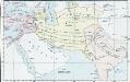
Vorderasien
Mittelasien, Iran