Maps of Rensselaer County

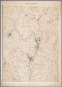
Albany and vicinity, New York / Henry Gannett, chief topographer ; H.M. Wilson, geographer in charge ; triangulation by N.Y. State Survey and by U.S. Coast and Geodetic Survey ; topography by Frank Sutton and J.H. Jennings
1 : 62500 Annotatie geografische gegevens: Opname: 1891-1892 Henry Gannett 1846-1914; Wilson, H.M.; Sutton, Frank; Jennings, J.H.; N.Y. State Survey; US Coast and Geodetic Survey [Washington, D.C. : U.S. Geological Survey]
The Hudson by daylight map, from New York Bay to the head of tide water : containing names of streams, islands, and heights of mountains according to the latest coast survey : also the names of prominent residences, historic land marks, the old reaches o
from Hudson River
Map of the Hudson River Rail Road from New York to Albany / engraved by Robt. Haering, N.Y. ; W.C. Moore, del.
from Hudson River
Albany - Troy - Schenectady and Vicinity (New York).
1 : 95040 Shell Oil Company
Rensselaer County.
1 : 151000 Burr, David H., 1803-1875
Watervliet [Township]; Watervliet Center [Village]; Watervliet Center Business Directory.; North Albany [Village]
from New topographical atlas of the counties of Albany and Schenectady, New York : from actual surveys / by S.N. & D.G. Beers and assistants.
Hudson River & vicinity / drawn by David H. Burr ; S. Stiles & Co., N.Y.
from Hudson River
Guilderland [Township]; Hamiltonville [Village]; Hamiltonville Business Directory.; Knowersville Business Directory.; Guilderland Centre [Village]; Guilderland Centre Business Directory.
from New topographical atlas of the counties of Albany and Schenectady, New York : from actual surveys / by S.N. & D.G. Beers and assistants.
Bethlehem [Township]
from New topographical atlas of the counties of Albany and Schenectady, New York : from actual surveys / by S.N. & D.G. Beers and assistants.
Albany
1 : 62500
Troy
1 : 62500
Albany
1 : 62500
Troy
1 : 62500
Troy
1 : 62500
Troy
1 : 62500
Troy
1 : 62500
Troy
1 : 62500
Albany
1 : 62500
Albany
1 : 62500
Albany
1 : 62500
Albany
1 : 62500
Albany
1 : 62500
Troy
1 : 48000
Albany
1 : 62500
Albany
1 : 62500
Albany
1 : 62500
Albany
1 : 62500
Albany
1 : 62500
Albany
1 : 62500
Albany
1 : 62500
Albany
1 : 62500
Troy
1 : 62500
Troy
1 : 62500
Troy
1 : 62500
Troy
1 : 62500
Troy
1 : 62500
Troy
1 : 62500
Troy
1 : 62500
Troy
1 : 62500
Albany
1 : 62500
Troy
1 : 62500