Maps of Town of Colonie

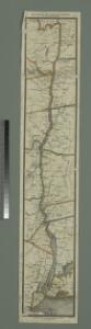
Hudson River & vicinity / drawn by David H. Burr ; S. Stiles & Co., N.Y.
from Hudson River
Watervliet [Township]; Watervliet Center [Village]; Watervliet Center Business Directory.; North Albany [Village]
from New topographical atlas of the counties of Albany and Schenectady, New York : from actual surveys / by S.N. & D.G. Beers and assistants.
Half Moon [Township]
from New topographical atlas of Saratoga Co., New York, from actual surveys by S. N. & D. G. Beers and assistants.
Stuyvesant [Township]; Stuyvesant Business Notices.
from Atlas of Columbia County, New York. From actual surveys and official records. Compiled & published by D. G. Beers & Co.
Stuyvesant Landing [Village]; Stockport [Township]
from Atlas of Columbia County, New York. From actual surveys and official records. Compiled & published by D. G. Beers & Co.
Niverville [Village]; Kinderhook [Township]
from Atlas of Columbia County, New York. From actual surveys and official records. Compiled & published by D. G. Beers & Co.
Half Moon, Saratoga County, New York.
1 : 42240 Beers, B.G.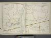
Portion of Albany & Greene County. ; Portion of Rensselaer & Columbia County.
from Atlas of the Hudson River Valley from New York city to Troy, including a section of about 8 miles in width. Published by Watson & co. Compiled from official records and careful surveys, under the supervision of F. W. Beers.
Stottville
1 : 24000
Stottville
1 : 24000
Stottville
1 : 24000
Kinderhook
1 : 24000
Kinderhook
1 : 24000
Kinderhook
1 : 24000
East Greenbush
1 : 24000
East Greenbush
1 : 24000
East Greenbush
1 : 24000
East Greenbush
1 : 24000
East Greenbush
1 : 24000
Troy South
1 : 24000
Troy South
1 : 24000
Troy South
1 : 24000
Troy South
1 : 24000
Troy South
1 : 24000
Troy South
1 : 24000
Troy North
1 : 24000
Troy North
1 : 24000
Troy North
1 : 24000
Troy North
1 : 24000