Maps of Western Region

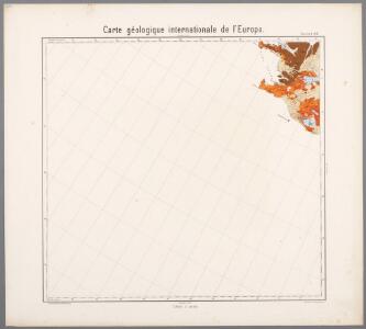
Feuille 8 (A II), uit: Carte géologique internationale de l'Europe : la carte, votée au congrès géologique international de Bologne en 1881, est exécutée conformément aux décisions d'une commission internationale, avec le concours des gouvernements, sous le dir. de M.M. Beyrich et Hauchecorne
Annotatie: Blad 48 gamme des couleurs; blad 49: bladwijzer en titelblad Heinrich Ernst Beyrich 1815-1896; Wi. Hauchecorne Berlin : Reimer / (Berlin: Institut lithographique)
[I], uit: Geognostische Karte des Oesterreichischen Kaiserstaates mit einem grossen Theile Deutschland's u. Italien / hauptsachlich nach ... Haidinger's geognostischer Karte dieses Staates bearb. von Josef Scheda
1 : 3000000 titelvariant: General-Karte von Europa in 25 Blättern; Annotatie: Bijlage bij: General-Karte von Europa in 25 Blättern. - 1:2.592.000. - 1845-1847 Scheda, Joseph Wien : K.K. Militär. Geografisch. Institut
Uppdráttur Íslands
1 : 250000 Island Geodetic institute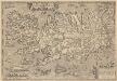
Islandia. [Karte], in: Theatrum orbis terrarum, S. 384.
1 Karte aus Atlas Ortelius, Abraham Vrients, Jan Baptista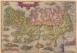
Islandia. [Karte], in: Theatrum orbis terrarum, S. 290.
1 Karte aus Atlas Ortelius, Abraham
Tabula Islandiae Auctore Georgio Carolo Flandro. [Karte], in: Theatrum orbis terrarum, sive, Atlas novus, Bd. 1, S. 39.
1 Karte aus Atlas Blaeu, Joan Blaeu, Willem Janszoon
Islandia. [Karte], in: Atlas, sive, Cosmographicae meditationes de fabrica mundi et fabricati figura, S. 77.
1 Karte aus Atlas Mercator, Gerhard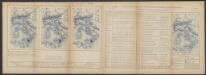
Tabula Islandiae [Karte], in: Le théâtre du monde, ou, Nouvel atlas contenant les chartes et descriptions de tous les païs de la terre, Bd. 1, S. 41.
1 Karte aus Atlas Blaeu, Willem Janszoon und Blaeu, Joan Blaeu, Willem Janszoon
Tabula Islandiae [Karte], in: Gerardi Mercatoris et I. Hondii Newer Atlas, oder, Grosses Weltbuch, Bd. 1, S. 45.
1 Karte aus Atlas Mercator, Gerhard und Hondius, Jodocus Jansson, Jan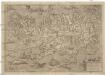
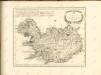
Islandia
1 : 2046000 Island Velleius, Andreas Frederik A. Ortel.
Sweden & Norway.
1 : 2217600 Arrowsmith, John
Tabula Islandiae [Karte], in: Novus Atlas, das ist, Weltbeschreibung, Bd. 1, S. 25.
1 Karte aus Atlas Blaeu, Joan Blaeu, Willem Janszoon
Tabula Islandiae [Karte], in: Novus atlas absolutissimus, Bd. 1, S. 164.
1 Karte aus Atlas Janssonius Offizin
Islandia. [Karte], in: Gerardi Mercatoris Atlas, sive, Cosmographicae meditationes de fabrica mundi et fabricati figura, S. 79.
1 Karte aus Atlas Mercator, Gerhard Montanus, Petrus
TABVLA | ISLANDIÆ
Auctore | Georgio Carolo | Flandro. [Abraham Ortelius] [Amsterdam : Joan Blaeu]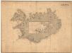
Museumskart 192: Iceland
J. W. Appleton Norie & Wilson
Danish Islands in the North Atlantic Ocean.
1 : 3000000 Fullarton, A. & Co.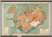
Iceland -- Physical-Political
1 : 500000 Danish General Staff
Charte von Island und den Färöer Inseln
1 : 1400000 Faerské ostrovy Streit, Friedrich Wilhelm
Charte von Island und den Färöer Inseln
1 : 1400000 Faerské ostrovy Streit, Friedrich Wilhelm
51. Iceland, Denmark. The World Atlas.
1 : 2500000 USSR (Union of Soviet Socialist Republics).

INSVLAE ISLANDIAE delineatio, prout haec Solenni mensurandi negotio sub Auspiciis Potentissimi Regis DANIAE facto, & a 1734 demum per Cnopfium Archit. militarem ad finem perducto, debetur
1 : 1600000 Island studio et impensis Homannianorum Heredum
Island
1 : 1350000 Annotatie: Met administratieve indeling [S.l. : s.n.]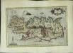
Islandia
1 Karte : Kupferdruck ; 26 x 42 cm Mercator; Hondius Henricus Hondius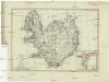
Charte von Island und den Färöer Inseln
1 : 1400000 Faerské ostrovy
CHARTE von ISLAND und den Färöer Inseln
1 : 1420000 Faerské ostrovy
Islande. Europe 1 bis.
1 : 1641836 Vandermaelen, Philippe, 1795-1869