Maps of China

China und Japan
Hand-Atlas über alle Theile der Erde nach dem neuesten Zustande und über das Weltgebäude Stieler, Adolf bei Justus Perthes
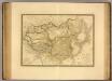
[Das Chinesische Reich mit seinen Schutzstaaten]
Hand-Atlas über alle Theile der Erde nach dem neuesten Zustande und über das Weltgebäude Stieler, Adolf bei Justus Perthes
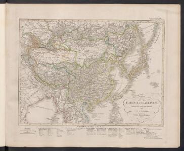
Das Chinesische Reich mit den Schutz-Staaten und Japan
Stieler's Hand-Atlas Stieler, Adolf bei Justus Perthes
Chinesisches Reich, Japan.
1 : 17000000 Flemming, Carl
Das Chinesische Reich mit seinen Schutzstaaten
Grosser Hand-Atlas über alle Theile der Erde in 170 Karten Meyer, J. Verlag des Bibliographischen Instituts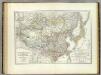
Chinesische Reich.
1 : 10800000 Weiland, C. F. (Carl Ferdinand), d. 1847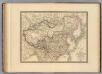
Empire Chinois, Japon.
1 : 13000000 Andriveau-Goujon, J.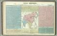
Tableau l'historie de L'Asie, Inde, Chine, Japon.
1 : 33200000 Duval, Henri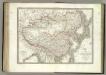
Empire Chinois, Japon.
1 : 12600000 Lapie, M. (Pierre), 1779-1850
Asie Orientale.
1 : 15000000 Garnier, F. A., 1803-1863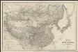
Karte von China und Japan
1 : 7100000 von H. B[erghaus] gest. v. Mädel II u. s. Sch. Gotha : Perthes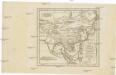
Charte von China und den angränzenden Ländern, und Völkerschaften so wie sie dem letzten Kaiser Tschien-Long unterworfen waren
Čína Kiepert, Heinrich Macartney, George Macartney
Mongolenreiche
1 : 48000000 Asien, Europa, Mongolen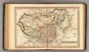
Chinese Empire.
1 : 31000000 Fenner, Rest.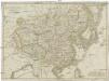
Chinesisches Reich
1 : 16800000 Čína Mollo, Tranquillo bey Tranquillo Mollo
Chinae, olim Sinarum regionis, nova descriptio. [Karte], in: Theatrum orbis terrarum, S. 393.
1 Karte aus Atlas Ortelius, Abraham Vrients, Jan Baptista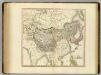
Tartary, Chinese & independent.
1 : 15000000 Cary, John, ca. 1754-1835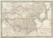
Das Chinesische Reich und das Kaiserthum Japan
1 : 10780000 Japonsko Humboldt, Alexander von im Verlage des Geograph. Institut
Das Chinesische Reich und das Kaiserthum Japan
1 : 10666000 entworfen und gezeichnet von C. F. Weiland Weimar : Verlag des Geograph. Instituts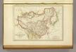
L'Empire Chinois et du Japon.
1 : 23600000 Malte-Brun, Conrad, 1775-1826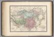
Empire Chinois et Japon.
1 : 14000000 Levasseur, E.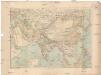
Asie
1 : 16000000 Asie Ch. Delagrave
Chinae, olim Sinarum regionis, nova descriptio. [Karte], in: Theatrum orbis terrarum, S. 298.
1 Karte aus Atlas Ortelius, Abraham
Indes, la Chine.
1 : 10700000 L'Isle, Guillaume de, 1675-1726
Indes, la Chine.
1 : 10700000 L'Isle, Guillaume de, 1675-1726
Tabula Asiae VIII. [Karte], in: Claud. Ptolemaeus. Geographia lat. cum mappis [...], S. 317.
1 Karte aus Atlas Münster, Sebastian [und Ptolemaeus, Claudius]
China Veteribus Sinarum Regio nunc Incolis Tame dicta. [Karte], in: Gerardi Mercatoris et I. Hondii Newer Atlas, oder, Grosses Weltbuch, Bd. 2, S. 356.
1 Karte aus Atlas Mercator, Gerhard und Hondius, Jodocus Jansson, Jan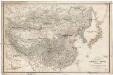
Karte VON CHINA UND JAPAN
1 : 6850000 Japonsko Berghaus, Heinrich Karl Wilhelm Anville, Jean-Baptiste Bourguinon d' Justus Perthes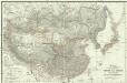
Karte von China und Japan
Japonsko Anville, Jean-Baptiste Bourguinon d' H.B.