Maps of China

Das Chinesische Reich mit den Schutz-Staaten und Japan
Stieler's Hand-Atlas Stieler, Adolf bei Justus Perthes
China und Japan
Hand-Atlas über alle Theile der Erde nach dem neuesten Zustande und über das Weltgebäude Stieler, Adolf bei Justus Perthes
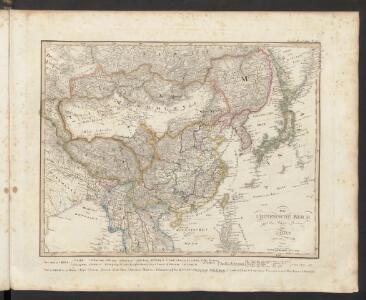
[Das Chinesische Reich mit seinen Schutzstaaten]
Hand-Atlas über alle Theile der Erde nach dem neuesten Zustande und über das Weltgebäude Stieler, Adolf bei Justus Perthes
Chinesisches Reich, Japan.
1 : 17000000 Flemming, Carl
Das Chinesische Reich mit seinen Schutzstaaten
Grosser Hand-Atlas über alle Theile der Erde in 170 Karten Meyer, J. Verlag des Bibliographischen Instituts
Asie Orientale.
1 : 15000000 Garnier, F. A., 1803-1863
Chinesische Reich.
1 : 10800000 Weiland, C. F. (Carl Ferdinand), d. 1847
Chinae, olim Sinarum regionis, nova descriptio. [Karte], in: Theatrum orbis terrarum, S. 393.
1 Karte aus Atlas Ortelius, Abraham Vrients, Jan Baptista
Empire Chinois, Japon.
1 : 13000000 Andriveau-Goujon, J.
Tableau l'historie de L'Asie, Inde, Chine, Japon.
1 : 33200000 Duval, Henri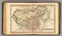
Chinese Empire.
1 : 31000000 Fenner, Rest.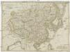
Chinesisches Reich
1 : 16800000 Čína Mollo, Tranquillo bey Tranquillo Mollo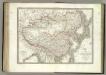
Empire Chinois, Japon.
1 : 12600000 Lapie, M. (Pierre), 1779-1850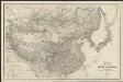
Karte von China und Japan
1 : 7100000 von H. B[erghaus] gest. v. Mädel II u. s. Sch. Gotha : Perthes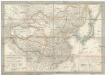
Das Chinesische Reich und das Kaiserthum Japan
1 : 10780000 Japonsko Humboldt, Alexander von im Verlage des Geograph. Institut
Das Chinesische Reich und das Kaiserthum Japan
1 : 10666000 entworfen und gezeichnet von C. F. Weiland Weimar : Verlag des Geograph. Instituts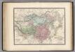
Empire Chinois et Japon.
1 : 14000000 Levasseur, E.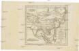
Charte von China und den angränzenden Ländern, und Völkerschaften so wie sie dem letzten Kaiser Tschien-Long unterworfen waren
Čína Kiepert, Heinrich Macartney, George Macartney
Chinae, olim Sinarum regionis, nova descriptio. [Karte], in: Theatrum orbis terrarum, S. 298.
1 Karte aus Atlas Ortelius, Abraham
China Veteribus Sinarum Regio nunc Incolis Tame dicta. [Karte], in: Gerardi Mercatoris et I. Hondii Newer Atlas, oder, Grosses Weltbuch, Bd. 2, S. 356.
1 Karte aus Atlas Mercator, Gerhard und Hondius, Jodocus Jansson, Jan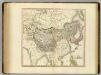
Tartary, Chinese & independent.
1 : 15000000 Cary, John, ca. 1754-1835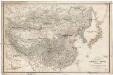
Karte VON CHINA UND JAPAN
1 : 6850000 Japonsko Berghaus, Heinrich Karl Wilhelm Anville, Jean-Baptiste Bourguinon d' Justus Perthes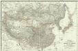
Karte von China und Japan
Japonsko Anville, Jean-Baptiste Bourguinon d' H.B.
Empire Chinois, Japon.
1 : 13600000 Picquet, C.
Chine et Japon.
1 : 10250000 Montemont, A.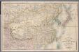
[Kaart], uit: Stanford's map of the empires of China and Japan : with the adjacent parts of the Russian Empire, India, Burma &c
1 : 6000000 titelvariant: Stanford's map of China & Japan; Annotatie: Omslagtitel: Stanford's map of China & Japan London : Stanford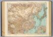
97-98. Dominio Cinese, Impero Giapponese.
1 : 10000000 Touring club italiano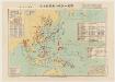
太平洋戰爭日本陸軍戰力喪失一覽圖
1 : 15000000 太平洋戰爭日本陸軍戰力喪失一覽圖 昭和二十二年[1947]4月30日,植野錄夫 编辑,东京:日本地圖株式會社发行。 此图反映了二战反攻阶段东亚、东南亚和太平洋地区盟军与日军的战斗形势,包括东北苏军进攻路线、中国本部反攻路线、东南亚和太平洋诸岛美军进攻路线等。图中用蓝色标注了此时日军在中国、东南亚及本岛的军队部署及战争损失统计。附表罗列自1937年以来日本历次战争的名称、时间、参战部队及军力损失。另有《飛行機生産表》,显示日军战机的生产配备情况。 附插图1幅:《内地戰災被害状況圖》。 1图,彩色,日文,图幅61 x 86 cm,比例尺1:15,000,000,经纬度E80°-W160°;S10°-N55°。 Harvard-Yenching | Manchuguo J-0827;Hollis Number:014623825 植野錄夫 日本地圖株式會社
Indes, la Chine.
1 : 10700000 L'Isle, Guillaume de, 1675-1726