Maps of Europe

[Europaeisches Russland auch Schweden u. Norwegen, Dabei Uebersicht des Oesterreichischen u. Preussischen Staats]
Hand-Atlas über alle Theile der Erde nach dem neuesten Zustande und über das Weltgebäude Stieler, Adolf bei Justus Perthes
[Europaeisches Russland auch Schweden u. Norwegen]
Hand-Atlas über alle Theile der Erde nach dem neuesten Zustande und über das Weltgebäude Stieler, Adolf bei Justus Perthes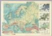
Europe - Physical. Pergamon World Atlas.
1 : 12500000 Polish Army Topography Service
Europe. Pergamon World Atlas.
1 : 25000000 Polish Army Topography Service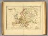
Europe.
1 : 102000000 Malte-Brun, Conrad, 1775-1826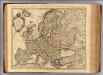
Carte d'Europe.
1 : 9000000 L'Isle, Guillaume de, 1675-1726
Europe. Pergamon World Atlas.
1 : 25000000 Polish Army Topography Service
Europa.
1 : 19600000 Reichard, C. G.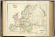
Europe.
1 : 10454400 Fullarton, A. & Co.
Europe.
1 : 14300000 Society for the Diffusion of Useful Knowledge (Great Britain)
(Europa, Asia, Africa, America)
Hubner, Johann, 1688-1731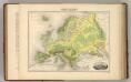
Europe. (Carte Hypsometrique).
1 : 14270000 Migeon, J.
Composite: Ost-Europa, Norwegen, Schweden, Russland, Kaukasien, Turkei .
1 : 3700000 Petermann, A.
Europe.
1 : 20000000 Woodbridge, William C.
Europe.
1 : 23000000 Arrowsmith, Aaron; Lewis, Samuel
Europe.
1 : 23500000 Arrowsmith, Aaron; Lewis, Samuel
Ethnographische Karte von Europa.
1 : 6000000 Berghaus, Heinrich
Karte von Europa
1 : 13000000 Evropa Fried, Franz Biller, Dominik Artaria
Russland und Skandinavien
Handatlas über alle Theile der Erde und über das Weltgebäude Stieler, Adolf Justus Perthes
Novissima Russiæ tabula / authore Isaaco Massa
1 : 8500000 Annotatie: Rechtsboven genummerd: VI; Met opdracht van Hondius aan Isaac Bernart; Origineel is Blad 135 in atlas factice; Annotatie geografische gegevens: Met 2 schaalstokken Isaac Abrahamszoon Massa 1586-1643; Henricus Hondius 1573-1650 [Amsterdam, Londen : apud Janssonio-Waesbergios, et Mosem Pitt]
Europe.
1 : 18000000 Greenleaf, Jeremiah
Europe.
1 : 31680000 Greenleaf, Jeremiah
Europe Politique.
1 : 14270000 Migeon, J.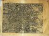
Evropa
1 Karte : Kupferdruck ; 20 x 26 cm Quad Johannes Bussemacher
Composite: Europe.
1 : 6000000 Lizars, Daniel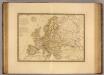
Europe en 1789.
1 : 12300000 Picquet, C.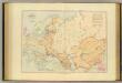
Acquisitions of Russia in Europe, Central Asia.
1 : 9800000 Stanford, Edward
Novissima Russiae Tabula [Karte], in: Gerardi Mercatoris et I. Hondii Newer Atlas, oder, Grosses Weltbuch, Bd. 1, S. 124.
1 Karte aus Atlas Mercator, Gerhard und Hondius, Jodocus Jansson, Jan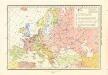
Historický atlas revolučního hnutí

![[Europaeisches Russland auch Schweden u. Norwegen, Dabei Uebersicht des Oesterreichischen u. Preussischen Staats]](https://images-0.georeferencer.com/images/iiif/770112616749/full/,300/0/native.jpg)

