Maps of Atlas Tellien

[Spanien und Portugal in 4 Blättern]
Hand-Atlas über alle Theile der Erde nach dem neuesten Zustande und über das Weltgebäude Stieler, Adolf bei Justus Perthes
Feuille 37 (B VI), uit: Carte géologique internationale de l'Europe : la carte, votée au congrès géologique international de Bologne en 1881, est exécutée conformément aux décisions d'une commission internationale, avec le concours des gouvernements, sous le dir. de M.M. Beyrich et Hauchecorne
Annotatie: Blad 48 gamme des couleurs; blad 49: bladwijzer en titelblad Heinrich Ernst Beyrich 1815-1896; Wi. Hauchecorne Berlin : Reimer / (Berlin: Institut lithographique)
Accuratissima et nunc novissimè revisa correctaque tabula regnorum, Valentiæ et Murciæ, insularum Majorcæ, Minorcæ et Jvicæ
1 Karte : Kupferdruck ; 47 x 58 cm Ottens; Ottens R. et J. Ottens
Spain & Portugal - eastern section.
1 : 2000000 John Bartholomew and Son
[Spanien und Portugal in 4 Blättern]
Hand-Atlas über alle Theile der Erde nach dem neuesten Zustande und über das Weltgebäude Stieler, Adolf bei Justus Perthes
[Spanien und Portugal in 4 Blättern]
Hand-Atlas über alle Theile der Erde und über das Weltgebäude Stieler, Adolf Justus Perthes
Curiosa nova tabula complectens regnum Valentiae et Murciae nec non Insulas Ivicam, Majorcam et Minorcam
1 : 1350000 per Jacobum Robyn [Luggerdus van Anse schulp.] Amsterdam : [s.n.]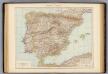
Spanien, Portugal.
1 : 3000000 Andree, Richard
Carte de la Peninsule Hispanique.
1 : 2750000 Vivien de St Martin, L.
Le royaume de Murcie, partie des royaumes de Valence, de Castille Nouvelle, de Grenade [et]c. et l'isle d'Yviça
1 Karte : Kupferdruck ; 44 x 56 cm Jaillot; Dezauche; Cordier chez Dezauche successeur des S.rs De l'Isle et Buache rue des Noyers pres celle des Anglois
Regna Hispaniarum, atque Portugalliæ, 4
1 Blatt : 53 x 64 cm Gerard Valck
Theatre de la guerre en Espagne et en Portugal, 4
1 Blatt : 51 x 63 cm Covens et Mortier
Espagne et Portugal. Flle. S.E.
1 : 1250000 Vivien St Martin, L.
[Spanien und Portugal, Blatt 4]
Adolf Stieler's Handatlas über alle Theile der Erde und über das Weltgebäude Stieler, Adolf Justus Perthes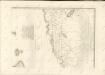
De Middellandsche Zee van Gibralter tot Algiers
Spain Gerard van Keulen
Spanische Halbinsel, Blatt 4.
1 : 1500000 Vogel, C.
Regnorum Castellæ veteris Legionis et Gallæciæ principatuumque Biscaiæ et Asturiarum accuratissima descriptio, 6
1 Blatt : 54 x 42 cm Visscher
[Spanien und Portugal in 4 Blättern, Blatt 4]
Handatlas über alle Theile der Erde und über das Weltgebäude Stieler, Adolf Justus Perthes

Neueste Generalkarte von Portugal und Spanien, 6
1 Blatt : 70 x 50 cm Schrämbl
Algier
1 : 2350000 Alžírsko Weiland, Karl Ferdinand Geograph. Institut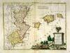
Li regni di Valenza et Murcia con l'isole Baleari, e Pitiuse
1 Karte : Kupferdruck ; 29 x 39 cm Zatta presso Antonio Zatta
Spanien oest.
1 : 2350000 Radefeld, Carl Christian Franz, 1788-1874
Carte De La Mer Mediterranee. II.
Roux, Joseph
Algier
1 : 2350000 entw. und gezeichnet von C. F. Weiland Weimar : Verlag des Geograph. Instituts
A new Military Map of Spain and Portugal compiled from The Nautical Surveys of Don Vincent Tofiño, the new Provincial maps of Don Tomas Lopez, the large map of the Ptrenees by Roussill, and various original documents
1 Mapa en 4 seccions dins d'un estoig. John Stockdale J. Stockdale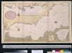
Een gedeelte van de Middelanse Zee van Gibraltar tot Ivica
Spain Gerard van Keulen
Neueste Generalkarte von Portugal und Spanien, 5
1 Blatt : 70 x 50 cm Schrämbl
![[Spanien und Portugal in 4 Blättern]](https://images-2.georeferencer.com/images/iiif/642223247885/full/,300/0/native.jpg)

