Maps of Almeria

Le royaume de Murcie, partie des royaumes de Valence, de Castille Nouvelle, de Grenade [et]c. et l'isle d'Yviça
1 Karte : Kupferdruck ; 44 x 56 cm Jaillot; Dezauche; Cordier chez Dezauche successeur des S.rs De l'Isle et Buache rue des Noyers pres celle des Anglois
[Spanien und Portugal in 4 Blättern]
Hand-Atlas über alle Theile der Erde nach dem neuesten Zustande und über das Weltgebäude Stieler, Adolf bei Justus Perthes
[Spanien und Portugal in 4 Blättern]
Hand-Atlas über alle Theile der Erde und über das Weltgebäude Stieler, Adolf Justus Perthes
Accuratissima et nunc novissimè revisa correctaque tabula regnorum, Valentiæ et Murciæ, insularum Majorcæ, Minorcæ et Jvicæ
1 Karte : Kupferdruck ; 47 x 58 cm Ottens; Ottens R. et J. Ottens
Espagne et Portugal. Flle. S.E.
1 : 1250000 Vivien St Martin, L.
[Spanien und Portugal, Blatt 4]
Adolf Stieler's Handatlas über alle Theile der Erde und über das Weltgebäude Stieler, Adolf Justus Perthes
Spanische Halbinsel, Blatt 4.
1 : 1500000 Vogel, C.
Regna Hispaniarum, atque Portugalliæ, 4
1 Blatt : 53 x 64 cm Gerard Valck
[Spanien und Portugal in 4 Blättern, Blatt 4]
Handatlas über alle Theile der Erde und über das Weltgebäude Stieler, Adolf Justus Perthes
Curiosa nova tabula complectens regnum Valentiae et Murciae nec non Insulas Ivicam, Majorcam et Minorcam
1 : 1350000 per Jacobum Robyn [Luggerdus van Anse schulp.] Amsterdam : [s.n.]
Theatre de la guerre en Espagne et en Portugal, 4
1 Blatt : 51 x 63 cm Covens et Mortier
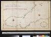
De Middellandsche Zee van Gibralter tot Algiers
Spain Gerard van Keulen
Regnorum Castellæ veteris Legionis et Gallæciæ principatuumque Biscaiæ et Asturiarum accuratissima descriptio, 6
1 Blatt : 54 x 42 cm Visscher
Carte De La Mer Mediterranee. II.
Roux, Joseph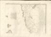

Neueste Generalkarte von Portugal und Spanien, 6
1 Blatt : 70 x 50 cm Schrämbl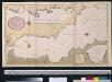
Een gedeelte van de Middelanse Zee van Gibraltar tot Ivica
Spain Gerard van Keulen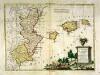
Li regni di Valenza et Murcia con l'isole Baleari, e Pitiuse
1 Karte : Kupferdruck ; 29 x 39 cm Zatta presso Antonio Zatta
A new Military Map of Spain and Portugal compiled from The Nautical Surveys of Don Vincent Tofiño, the new Provincial maps of Don Tomas Lopez, the large map of the Ptrenees by Roussill, and various original documents
1 Mapa en 4 seccions dins d'un estoig. John Stockdale J. Stockdale
Spanien SO.
1 : 1800000 Theinert, A.
[Carte d'Espagne et de Portugal en neuf feuilles, 9]
1 Blatt : 31 x 41 cm P.G. Chanlaire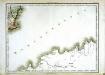
Espagne et Portugal, 9
1 Blatt : 31 x 42 cm Mentelle
Alger
1 : 500000 Service géographique de l'armée
Regni Valenciae tabula ad originalia D. T. Lopez in hanc commodam formam reducta / Homann Hered. excud.
1 Mapa. Fons Iglésies Homannischen Erben 0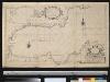
Carte particuliere des côstes d'Espagne et Barbarie depuis Gibralter jusqu'à C. de Palle et depuis Ceuta jusqu'au C. Ferat
Spain Henri Michelot Gerard van Keulen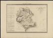
Murcia con las nuevas divisiones
1 : 600000 formado por A. H. Dufour Paris : Bulla
Mapa del obispado y reyno de Murcia
1 Karte : Kupferdruck ; 36 x 36 cm López; Vidal y Pinilla s.n.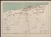
Département d'Alger. Carte des voies de communication
1 : 400000 Calléja; Algérie. Direction de l'agriculture et de la colonisation Alger : lith. Adolphe Jourdan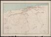
![Le royaume de Murcie, partie des royaumes de Valence, de Castille Nouvelle, de Grenade [et]c. et l'isle d'Yviça](http://biblio.unibe.ch/web-apps/maps/zoomify.php?pic=Ryh_1604_18.jpg&col=ryh)

