Maps of Marmara Region
Carte Générale de la Valachie, de la Bulgarie et de la Roumilie
Nouvel atlas physique politique et historique de l'Empire ottoman et des états limitrophes en Europe, en Asie et en Afrique, en quarante feuilles Hellert, J.J. Bellizard, Dufour et Cie
Macedonia et Thracia.
1 : 5700000 Fenner, Rest.
Thraciae Veteris Typus. [Karte], in: Theatrum orbis terrarum, S. 407.
1 Karte aus Atlas Ortelius, Abraham
Bulgarien nach den Balkankriegen
Bulgarien Balkankriege Häusler, Ines
Modifications territoriales dans le Balkans: Conférence de Londres ; Traité de Bukarest
Balkanhalbinsel Bukarest / Friede <1913> Staatsgrenze Londoner Vertrag Th. Weinreb del.
Die europaeische Türkei von der Gränze Griechenlands bis zu den Mündungen der Donau
1 : 2500000 Evropa jihovýchodní Stülpnagel, Friedrich von Justus Perthes
Die europaeische Türkei von der Gränze Griechenlands bis zu den Mündungen der Donau
osmanská říše Stülpnagel, Friedrich von Hanemann, August Justus Perthes
Die europaeische Türkei von der Gränze Griechenlands bis zu den Mündungen der Donau
osmanská říše Stülpnagel, Friedrich von Hanemann, August Justus Perthes
Černá Hora, Srbsko a Bulharsko dle ustanovení míru Sv.-Štěpánského
Černá Hora Fáborský, Jan B. Nipočić, Vasilij Bohuslav Pichl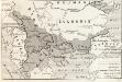
Modifications territoriales dans le Balkans: Traité de Bukarest
Balkanhalbinsel Bukarest / Friede <1913>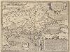
Thraciae Veteris Typus. [Karte], in: Theatrum orbis terrarum, S. 511.
1 Karte aus Atlas Ortelius, Abraham Vrients, Jan Baptista
Südosteuropa 1919-1941/44
Südosteuropa Grenzen
Corso del Danvbio da Belgrado sino al Mar Nero
1 : 2300000 Mollova mapová sbírka De Rossi, Giovanni Giacomo Mariotti, Vincenzo De Rossi, Giovanni Giacomo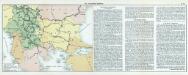
Nr. 18. Die Eroberung Serbiens
Serbien Weltkrieg <1914-1918>, Eroberung

Albanie Supre., Roumilie, Servie, Bulgarie, Valachie
Nouvel atlas physique politique et historique de l'Empire ottoman et des états limitrophes en Europe, en Asie et en Afrique, en quarante feuilles Hellert, J.J. Bellizard, Dufour et Cie
Graecaei pars septentrionalis
1 : 1300000 Řecko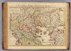
Graeciae pars Septentrionalis.
1 : 1280000 L'Isle, Guillaume de, 1675-1726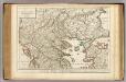
Graeciae pars Septentrionalis.
1 : 1280000 L'Isle, Guillaume de, 1675-1726
Der Südost-Balkan 1919-1941
Südosteuropa
Turkey in Europe.
1 : 3500000 Hughes, William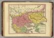
Graecia Pars Septentrionalis aliter Macedonia, Thessalia & Epirus cum Tracia. (1826)
1 : 2900000 Tanner, Henry S.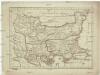
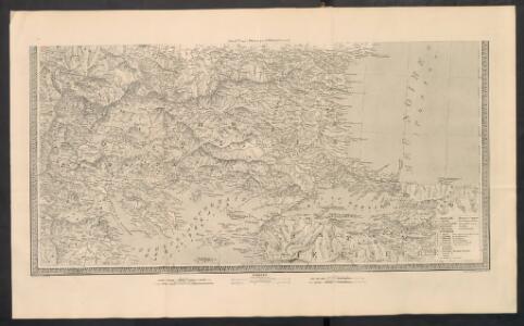
Macedonia Thracia Moesia et Illyris Graeca
1 : 2500000 Ilýrie
(Europaischen Turkei) 4.
1 : 1580000 Berghaus, Heinrich; Flemming, Carl; Handtke, Friedrich H.; Sohr, Karl
Bulgarie
1 : 1000000 Bulharsko Service Géographique de l'Armée Britannique
Thracia et Illyricum
1 : 1170000 Ilýrie Reichard, Christian Gottlieb Campius, D. D. Campii
Balkan-Uebersichtskarte
1 : 2250000 Balkanhalbinsel
Bulgarie d'après la conférence de Constantinople1876-1877
Bulgarien