Maps of Bulgaria
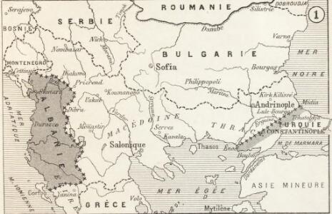
Modifications territoriales dans le Balkans: Conférence de Londres ; Traité de Bukarest
Balkanhalbinsel Bukarest / Friede <1913> Staatsgrenze Londoner Vertrag Th. Weinreb del.
Modifications territoriales dans le Balkans: Traité de Bukarest
Balkanhalbinsel Bukarest / Friede <1913>
Nr. 18. Die Eroberung Serbiens
Serbien Weltkrieg <1914-1918>, Eroberung
Südosteuropa 1878
Südosteuropa Berliner Kongress
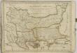
Die europaeische Türkei von der Gränze Griechenlands bis zu den Mündungen der Donau
1 : 2500000 Evropa jihovýchodní Stülpnagel, Friedrich von Justus Perthes
Die europaeische Türkei von der Gränze Griechenlands bis zu den Mündungen der Donau
osmanská říše Stülpnagel, Friedrich von Hanemann, August Justus Perthes
Die europaeische Türkei von der Gränze Griechenlands bis zu den Mündungen der Donau
osmanská říše Stülpnagel, Friedrich von Hanemann, August Justus Perthes
Mapa Balkánu

Südosteuropa 1919-1941/44
Südosteuropa Grenzen
[Die Europäische Türkei]
Hand-Atlas über alle Theile der Erde nach dem neuesten Zustande und über das Weltgebäude Stieler, Adolf bei Justus Perthes
G. Freytag's Karte der Balkan-Halbinsel
1 : 1250000 Balkánský poloostrov G. Freytag & Berndt
Graecia Pars Septentrionalis aliter Macedonia, Thessalia & Epirus cum Tracia. (1826)
1 : 2900000 Tanner, Henry S.
G. Freytags Karte des Kriegsschauplatzes auf der Balkanhalbinsel
Balkanhalbinsel Osmanisches Reich
Černá Hora, Srbsko a Bulharsko dle ustanovení míru Sv.-Štěpánského
Černá Hora Fáborský, Jan B. Nipočić, Vasilij Bohuslav Pichl
Die Euopaeische Türkei von der Gränze Griechenlands bis zu den Mündungen der Donau
Hand-Atlas über alle Theile der Erde nach dem neuesten Zustande und über das Weltgebäude Stieler, Adolf bei Justus Perthes
Balkan
Balkanhalbinsel
Das Erste Bulgarische Reich (680-1018 n. Chr.)
Bulgarien
Europae tabula IX
1 : 5600000 1 Karte : Kupferdruck ; 19 x 25 cm Ptolemaeus, Claudius [Vincenzo Valgrisi]
Albanie Supre., Roumilie, Servie, Bulgarie, Valachie
Nouvel atlas physique politique et historique de l'Empire ottoman et des états limitrophes en Europe, en Asie et en Afrique, en quarante feuilles Hellert, J.J. Bellizard, Dufour et Cie
Balkan-Uebersichtskarte
1 : 2250000 Balkanhalbinsel

Der Südost-Balkan 1919-1941
Südosteuropa
Macedonia et Thracia.
1 : 5700000 Fenner, Rest.
Paasche's Frontenkarte, Nr.6. Der Krieg gegen Russland

Graecaei pars septentrionalis
1 : 1300000 Řecko
Turkey in Europe.
1 : 3500000 Hughes, William
Dacia, Moesia, Illyris Graeca, Macedonia et Thracia
Balkanhalbinsel, Römisches Reich, Verwaltungsgliederung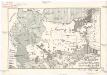
Národopisná mapa Balkánského bojiště
balkánské země Papáček, Pavel Florinskij, Timofej Dmitrijevič