Maps of Poland

[Ost-Europa in 6 Blättern, Enthaltend: Norwegen, Schweden, Russland, Kaukasien und die Türkei, Blatt 3]
Hand-Atlas über alle Theile der Erde und über das Weltgebäude Stieler, Adolf Justus Perthes
[Ost-Europa, Blatt 3]
Adolf Stieler's Handatlas über alle Theile der Erde und über das Weltgebäude Stieler, Adolf Justus Perthes
[Ost-Europa in 6 Blättern, Blatt 3]
Handatlas über alle Theile der Erde und über das Weltgebäude Stieler, Adolf Justus Perthes
Ost-Europa, No. 3: Sud-Schweden, die Russischen Ostsee-Provinzen, Polen & West-Russland.
1 : 3700000 Petermann, A.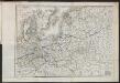
Carte du Théâtre de la Guerre en Russie et en Allemagne pendant 1812 et 1813
Russland, Deutschland, Befreiungskriege <1813-1815>
Part of North of Europe.
1 : 3800000 Melish, John
Kirchenprovinzen Gnesen, Riga u. Lemberg XV. Jahrh.
1 : 24000000 Ostmitteleuropa Kirchenprovinz
Oostelijk operatietooneel
1 : 2250000 Annotatie geografische gegevens: Legenda Den Haag : J. Smulders & Co.
Téatre De La Guerre Des Couronnes du Nord. [Karte], in: Atlas nouveau, contenant toutes les parties du monde [...], Bd. 1, S. 67.
1 Karte aus Atlas Sanson, Nicolas Jaillot, Alexis Hubert und Mortier, Pieter
Die Ältesten Karten von Deutschland

Nord- und Ostseeherrschaft III
1 : 10000000 Ostseeraum, Deutscher Orden, Deutsche Hanse
G. Freytags Übersichtskarte des deutsch-russischen Kriegsschauplatzes
1 : 2000000 Německo Kartogr. Anstalt G. Freytag & Berndt
Kirchenprovinzen Gnesen u. Riga im XIII. Jahrh.
1 : 24000000 Gniezno, Riga, Kirchenprovinz
[Kaart], uit: G. Freytags Übersichtskarte des Deutsch-Russischen Kriegsschauplatzes
1 : 2000000 titelvariant: Übersichtskarte des Deutsch-Russischen Kriegsschauplatzes; Annotatie: Omslagtitel: Übersichtskarte des Deutsch-Russischen Kriegsschauplatzes Freytag, G. Wien : Freytag & Berndt

Carte von Polen und einen grossen Theil der angrenzenden Laender
1 : 1300000 Evropa střední a východní Rendziny, Stanislaus Gilly Tranquillo Mollo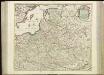
[71][71] Regni Poloniae et Ducatus Lithuaniae ..., uit: Atlas sive Descriptio terrarum orbis
Annotatie: Gedigitaliseerde versie. Amsterdam. Heiloo : Picturae (vervaardiger), 2015. tiff-bestand. Gedigitaliseerd: 07-01-2015; Origineel: Universiteitsbibliotheek Vrije Universiteit (XL.05127.-) ; Netherlands; Titelpagina ontbreekt Wit, Frederik de Amsterdam : Frederick de Wit
Regnum Poloniae eiusque confinia
1 : 11100000 1 Karte : Kupferdruck ; 13 x 17 cm Weigel, Johann Christoph [Johann Christoph Weigel]
Reise Charte durch das Königreich Polen mit allen darzu gehörigen Laendern / verfertiget von JG. S
1 : 9300000 1 Karte : Kupferdruck ; 16 x 21 cm, Bildgr. 17 x 25 cm Schreiber, Johann Georg [J. G. Schreiber]
Ostmitteleuropa 1989
Ostmitteleuropa Kunz, Andreas ; Treiling, Thomas
Ostsee-Laender von der Oder bis zur Newa
Stieler's Hand-Atlas Stieler, Adolf bei Justus Perthes

Ostmitteleuropa 1815
Ostmitteleuropa Kunz, Andreas ; Johnen, Bettina ; Moeschl, Joachim Robert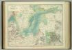
Basin of the Baltic.
1 : 2400000 Johnston, W. & A.K.
Polska za Mieczyslawa I
Polsko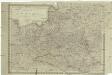
Königreich Pohlen
1 : 2055000 Bělorusko Schönberg, Johann Müller, And. Johann Schönberg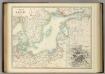
Basin of the Baltic.
1 : 2400000 Johnston, Alexander Keith
Partitions of Poland. 1918
1 : 4000000 Partitions of Poland. 1918. Partitions of 1772, 1793, 1795. Russia, Prussia, Austria. War Office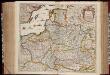
Regni Poloniae et ducatus Lithvaniae Voliniae, Podoliae Vcraniae Prvssiae, Livoniae et Cvrlandiae / descriptio emendata per F. de Wit Amstelodami
1 : 3000000 Annotatie: Rechtsboven: 14; Origineel is Blad 132 in atlas factice; Annotatie geografische gegevens: Met schaalstok: 15 Duytsche Mylen Frederick de Wit 1630-1706 [Amsterdam : F. de Wit]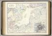
![[Ost-Europa in 6 Blättern, Enthaltend: Norwegen, Schweden, Russland, Kaukasien und die Türkei, Blatt 3]](https://images-2.georeferencer.com/images/iiif/544281158123/full/,300/0/native.jpg)

