Maps of Andalucía

[Spanien und Portugal in 4 Blättern]
Hand-Atlas über alle Theile der Erde und über das Weltgebäude Stieler, Adolf Justus Perthes
[Spanien und Portugal in 4 Blättern]
Hand-Atlas über alle Theile der Erde nach dem neuesten Zustande und über das Weltgebäude Stieler, Adolf bei Justus Perthes
Partie meridionale du royaume de Portugal, partie des royaumes de Castille nouvelle, de Andalousie et de Grenade
1 Karte : Kupferdruck ; 44 x 56 cm Jaillot; Dezauche chez Dezauche successeur des Sieurs Del'Isle et Buache 1.ers geographes du roi rue des Noyers près celle des Anglois
Carte nouvelle de la partie meridionale du royaume de Portugal et des Algarves
1 Blatt : 46 x 59 cm Covens et Mortier
A new Military Map of Spain and Portugal compiled from The Nautical Surveys of Don Vincent Tofiño, the new Provincial maps of Don Tomas Lopez, the large map of the Ptrenees by Roussill, and various original documents
1 Mapa en 4 seccions dins d'un estoig. John Stockdale J. Stockdale
Perfectissima geographica delineatio Regnorum Vandalitiae, Granatae, et Algarbiae; tractuum, Meridionalium Portugalliae Extremadurae ac Castellae Novae
1 : 1100000 summâ diligentià correcta et edita a R. & I. Ottens Amst. Batavo. Amst. R. & I. Ottens

Perfectissima geographica delineatio regnorum Vandalitiæ, Granatæ, et Algarbiæ
1 Karte : Kupferdruck ; 47 x 58 cm Ottens; Ottens R. et J. Ottens
Spanien, Portugal SW.
1 : 1800000 Berghaus, Heinrich; Flemming, Carl; Sohr, Karl; Theinert, A.
Regna Hispaniarum, atque Portugalliæ, 3
1 Blatt : 53 x 63 cm Gerard Valck
[Spanien und Portugal, Blatt 3]
Adolf Stieler's Handatlas über alle Theile der Erde und über das Weltgebäude Stieler, Adolf Justus Perthes
Espagne et Portugal. Flle. S.O.
1 : 1250000 Vivien St Martin, L.
Les frontieres d'Espagne et de Portugal
1 Karte : Kupferdruck ; 57 x 42 cm Fer; Starckman chez l'auteur dans l'isle du Palais sur le quay de l'orloge a la sphere royale
Regnum Castellæ novæ, Andalusiæ, Granadæ, et Algarbiæ, nec non maxime partis Portugalliæ, et Extremaduræ
1 Karte : Kupferdruck ; 45 x 55 cm Danckerts Justus Danckerts
Spanien Und Portugal In 4 Blattern. Blatt 3.
1 : 1500000 Vogel, C.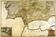
Regnorum Castellæ novæ Andalusiæ Granadæ Valentiæ et Murciæ accurata tabula
1 Karte auf 2 Blatt : Kupferdruck ; 52 x 81 cm Visscher Nicolaes Visscher
[Spanien und Portugal in 4 Blättern, Blatt 3]
Handatlas über alle Theile der Erde und über das Weltgebäude Stieler, Adolf Justus Perthes
Neueste Generalkarte von Portugal und Spanien
Portugalsko Votésky, Michael Benedicti, Hieronymus F.A. Schraembl
Neueste Generalkarte von Portugal und Spanien, 4
1 Blatt : 69 x 50 cm Schrämbl
Regnorum Castellæ veteris Legionis et Gallæciæ principatuumque Biscaiæ et Asturiarum accuratissima descriptio, 4
1 Blatt : 54 x 41 cm Visscher
Portugall.
from A new systeme of the mathematicks: containing I. Arithmetick, as well natural and decimal, as in species, or the principles of algebra. II. Practical geometry, together with the first six books of Euclid's Elements, as also the eleventh and twelfth, symbo
Mapa dos reynos de Portugal e Algarve
1 Karte : Kupferdruck ; 58 x 41 cm Lattré; Rizzi-Zannoni; Marillier; Berthault en casa de M. Lattré
Portugalliae et Algarbiae regna
1 : 1740000 Algarve (Portugalsko) Seutter, Matthäus cura et studio Matthaei Seutteri
Karte von den Königreichen Portugal und Algarbien
1 Karte : Kupferdruck ; 48 x 33 cm Sotzmann; López; Ramberg; Rizzi-Zannoni; Büsching; Jefferys s.n.
El reyno de Portugal subdividido en muchas provincias
1 Karte : Kupferdruck ; 67 x 50 cm Longchamps en casa del autor, en casa del Barthelmy
Andalvsia
1 Karte : Kupferdruck ; 15 x 25 cm Lambert Andreae
[Carte d'Espagne et de Portugal en neuf feuilles, 7]
1 Blatt : 31 x 41 cm P.G. Chanlaire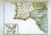
Espagne et Portugal, 7
1 Blatt : 31 x 42 cm Mentelle
Partie meridionale du royaume de Portugal
1 Karte : Kupferdruck ; 47 x 52 cm Bellin; Santini; Remondini chez M. Remondini
![[Spanien und Portugal in 4 Blättern]](https://images-2.georeferencer.com/images/iiif/533398703705/full/,300/0/native.jpg)

