Maps of Oberösterreich

Königreich Bayern
Grosser Hand-Atlas über alle Theile der Erde in 170 Karten Meyer, J. Verlag des Bibliographischen Instituts
Charte von Salzburg, Passau, Aichstaedt und Berchtesgaden
1 : 530000 Berchtesgaden (Německo) Kipferling, Karl Joseph Kunst und Industrie Comptoirs
Charte von Salzburg, Passau, Aichstaedt und Berchtesgaden
1 : 535000 Berchtesgaden (Německo) Kipferling, Karl Joseph Kunst und Industrie Comptoirs
[51][51] Circulus Bavaricus ..., uit: Atlas sive Descriptio terrarum orbis
Annotatie: Gedigitaliseerde versie. Amsterdam. Heiloo : Picturae (vervaardiger), 2015. tiff-bestand. Gedigitaliseerd: 07-01-2015; Origineel: Universiteitsbibliotheek Vrije Universiteit (XL.05127.-) ; Netherlands; Titelpagina ontbreekt Wit, Frederik de Amsterdam : Frederick de Wit
Tipus Vindelicae Sive Utriusque, Bavariae, secundum [Karte], in: Theatrum orbis terrarum, S. 72.
1 Karte aus Atlas Ortelius, Abraham
Bavaria Ducatus [Karte], in: Gerardi Mercatoris Atlas, sive, Cosmographicae meditationes de fabrica mundi et fabricati figura, S. 385.
1 Karte aus Atlas Mercator, Gerhard Montanus, Petrus
Bavaria Ducatus [Karte], in: Theatrum orbis terrarum, sive, Atlas novus, Bd. 1, S. 271.
1 Karte aus Atlas Blaeu, Joan Blaeu, Willem Janszoon
Bavaria dvcatvs
1 Karte : Kupferdruck ; 37 x 49 cm Blaeu; Mercator apud Guiljelmum Blaeu
Bavaria ducatus
1 Karte : Kupferdruck ; 21 x 27 cm Quad; Bussemacher excudit Iohan Bussemacher
Bavaria Ducatus [Karte], in: Gerardi Mercatoris et I. Hondii Newer Atlas, oder, Grosses Weltbuch, Bd. 1, S. 304.
1 Karte aus Atlas Mercator, Gerhard und Hondius, Jodocus Jansson, Jan
Bavaria Ducatus [Karte], in: Novus Atlas, das ist, Weltbeschreibung, Bd. 1, S. 222.
1 Karte aus Atlas Blaeu, Joan Blaeu, Willem Janszoon
Bavaria Ducatus [Karte], in: Le théâtre du monde, ou, Nouvel atlas contenant les chartes et descriptions de tous les païs de la terre, Bd. 1, S. 254.
1 Karte aus Atlas Blaeu, Willem Janszoon und Blaeu, Joan Blaeu, Willem Janszoon
Charte von Salzburg, Passau, Aichstædt und Berchtesgaden
1 Karte : Kupferdruck ; 45 x 55 cm Kipferling Im Verlage des Kunst und Industrie Comptoirs

BAVARIA | DVCATVS
Per Ger. Mercatorem Apud Guiljelmum Blaeu

VII, uit: General-Karte des oesterreichischen Kaiserstaates mit einem grossen Theile der angrenzenden Länder / durch Josef Scheda ... bearb. und hrsg
1 : 576000 Annotatie geografische gegevens: Maatstokken: oesterreichische Meilen, geografische oder deutsche Meilen, preussische Meilen, türkische Berri, französische Lieues, russische Werste; Maatstok per blad: wiener Klafter, öster. Meilen; Blad XIX: statistische en taalkundige informatie; Blad XIX: legenda [Wien : K.K. Militärisch-Geografisches Institut]
Bavaria dvcatvs
1 Karte : Kupferdruck ; 35 x 46 cm Mercator; Hondius excusum apud Henricum Hondium sub insigno Atlantis
Bavaria dvcatvs
1 Karte : Kupferdruck ; 35 x 45 cm Mercator s.n.
Bavariae, Olim Vindeliciae, Delineationis Compendium [Karte], in: Theatrum orbis terrarum, S. 171.
1 Karte aus Atlas Ortelius, Abraham
Bavariae, Olim Vindeliciae, Delineationis Compendium [Karte], in: Theatrum orbis terrarum, S. 263.
1 Karte aus Atlas Ortelius, Abraham Vrients, Jan Baptista
Handkarte des Erzherzogtumes Österreich
1 : 750000 Enns (Rakousko) Schober, Karl k. u. k. Militärgeographische Institutes
Bavariæ superioris et inferioris nova descriptio
1 Karte : Kupferdruck ; 37 x 45 cm Janssonius excudebat Ioannes Ianssonius
Bavariæ superioris et inferioris nova descriptio
1 Karte : Kupferdruck ; 36 x 44 cm Valck; Schenk penes Gerardum Valk et Petrum Schenk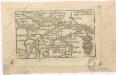
Soubor map

[Salzburg, Linz und Umgebung]
1 : 890000 Linec (Rakousko : oblast)
Bavaria dvcatvs
1 Karte : Kupferdruck ; 28 x 35 cm Merian Merian
Schulhandkarte des Erzherzogthumes Oesterreich ob der Enns und des Herzogthumes Salzburg
1 : 750000 Dolní Rakousko (Rakousko) Schober, Karl k. u. k. militär-geograph. Institut
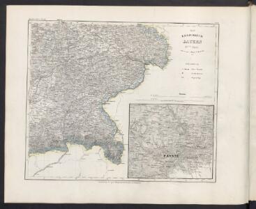
Das Erzherzogth. Österreich ob der Enns oder Oberösterreich, das Herzogth. Salzburg
Horní Rakousko (Rakousko) Ignaz Fuchs