Maps of Oberösterreich

Sheet VII: Karte Des Oesterreichischen Kaiserstaates.
1 : 576000 Scheda, Josef
VII, uit: General-Karte des oesterreichischen Kaiserstaates mit einem grossen Theile der angrenzenden Länder / durch Josef Scheda ... bearb. und hrsg
1 : 576000 Annotatie geografische gegevens: Maatstokken: oesterreichische Meilen, geografische oder deutsche Meilen, preussische Meilen, türkische Berri, französische Lieues, russische Werste; Maatstok per blad: wiener Klafter, öster. Meilen; Blad XIX: statistische en taalkundige informatie; Blad XIX: legenda [Wien : K.K. Militärisch-Geografisches Institut]
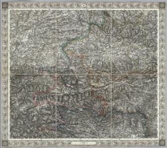
Strassen und Gebirgs-Karte zur Reise von Wien durch Österreich, Salzburg, Kärnthen, Steyermark und Tyrol bis München : mit Berücksichtigung der oesterreichischen Alpen und des Bayerischen Hochgebirgs
Artaria Co.
[München-Linz-Bruck].
1 : 576000 Rakousko Blumtritt, H. Oesfeld, C. W.
Strassen und Gebirgs-Karte zur Reise von Wien durch Oesterreich, Salzburg, Kärnthen, Steyermark und Tyrol bis München
1 : 576000 Alpy rakouské Schulz, R. A. Biller, Dominik Artaria & Co.
Salisburgensis Iurisdictionis, locorumque vicinorum vera descriptio [Karte], in: Theatrum orbis terrarum, S. 168.
1 Karte aus Atlas Ortelius, Abraham
S. R. I. principat. et archiepiscopatus Salisburgensis mappa geographica
1 Karte : Kupferdruck ; 48 x 56 cm Seutter Matthäus Seutter
L'archeveché de Saltzbourg
1 Karte : Kupferdruck ; 48 x 55 cm Le Rouge Georges Louis Le Rouge rue des Grands Augustins
Provincia archiepiscopatus Salisburgensis
1 Karte : Kupferdruck ; 25 x 35 cm Gutwein; Hansiz M. Happach & F.X. Schlüter
Salisburgensis Iurisdictionis, locorumque vicinorum vera descriptio [Karte], in: Theatrum orbis terrarum, S. 260.
1 Karte aus Atlas Ortelius, Abraham Vrients, Jan Baptista
S. R. I. principat. et archiepiscopatus Salisburgensis mappa geographica
1 Karte : Kupferdruck ; 48 x 56 cm Lotter Tobias Konrad Lotter
Salisburgensis Iurisdictionis, locorumque vicinorum vera descriptio [Karte], in: Theatrum orbis terrarum, S. 70.
1 Karte aus Atlas Ortelius, Abraham
Das Erzstift Salzburg mit der gefürsteten Probstey Berchtesgaden
1 Karte : Kupferdruck ; 23 x 27 cm Reilly F. J. J. von Reilly
Charte von Salzburg, Passau, Aichstædt und Berchtesgaden
1 Karte : Kupferdruck ; 45 x 55 cm Kipferling Im Verlage des Kunst und Industrie Comptoirs
S. R. I. principatvs et archiepiscopatus Salisburgensis
1 Karte : Kupferdruck ; 47 x 57 cm Guetrather; Homann Johann Baptist Homann
t'Aartsbisdom Saltzburg
1 : 1000000 gelegen na de stelling van de Hr. G. de l'Isle Deventer [etc.] : [by J. de Lat [etc.]
Saltzburg Archiepiscopatus, et Carinthia Ducatus. [Karte], in: Novus Atlas, das ist, Weltbeschreibung, Bd. 1, S. 219.
1 Karte aus Atlas Blaeu, Joan Blaeu, Willem Janszoon
Saltzburg archiepiscopatus cum ducatu Carinthiae [Karte], in: Gerardi Mercatoris Atlas, sive, Cosmographicae meditationes de fabrica mundi et fabricati figura, S. 406.
1 Karte aus Atlas Mercator, Gerhard Montanus, Petrus

Charte von Salzburg, Passau, Aichstaedt und Berchtesgaden
1 : 530000 Berchtesgaden (Německo) Kipferling, Karl Joseph Kunst und Industrie Comptoirs
Charte von Salzburg, Passau, Aichstaedt und Berchtesgaden
1 : 535000 Berchtesgaden (Německo) Kipferling, Karl Joseph Kunst und Industrie Comptoirs
Das Erzherzogth. Österreich ob der Enns oder Oberösterreich, das Herzogth. Salzburg
Horní Rakousko (Rakousko) Ignaz Fuchs
Saltzburg archiepiscopatus cum ducatu Carinthiae [Karte], in: Gerardi Mercatoris et I. Hondii Newer Atlas, oder, Grosses Weltbuch, Bd. 1, S. 337.
1 Karte aus Atlas Mercator, Gerhard und Hondius, Jodocus Jansson, Jan
Saltzburg Archiepiscopatus, et Carinthia Ducatus. [Karte], in: Theatrum orbis terrarum, sive, Atlas novus, Bd. 1, S. 274.
1 Karte aus Atlas Blaeu, Joan Blaeu, Willem Janszoon
Saltzbvrg archiepiscopatvs, et Carinthia dvcatvs
1 Karte : Kupferdruck ; 37 x 49 cm Mercator; Blaeu apud Guiljelmum Blaeu
S. R. I. Principatus et Archiepiscopatus Salisburgensis
1 : 430000 Mollova mapová sbírka Homann, Johann Baptist Homann, Johann Baptista
S. R. I. Principat. et Archiepiscopatus Salisburgensis
1 : 430000 Mollova mapová sbírka Seutter, Matthäus Seutter, Matthäus
Schulhandkarte des Erzherzogthumes Oesterreich ob der Enns und des Herzogthumes Salzburg
1 : 750000 Dolní Rakousko (Rakousko) Schober, Karl k. u. k. militär-geograph. Institut