Maps of West Indies

Westindien
Allgemeiner Atlas [Walch, Johannes] im Verlag bei Johannes Walch
West Indien oder Mittelamerika
Neuester Schul-Atlas Walch, Johann im Verlag bei Joh. Walch
Karte von Mittel America oder Westindien
1 : 1200000 Canzler, Friedrich Gottlieb, 1764-1811 Bey Homanns Erben, mit Röm. Kaiserl. Privilegio
West-Indien, Central-Amerika bis zum südlichen Canada in 4 Blättern
1 : 7500000 Südost-Blatt Petermann, August Heinrich ; Habenicht, H. Justus Perthes
[West-Indien, Central-Amerika bis zum südlichen Canada, Blatt 2]
Adolf Stieler's Handatlas über alle Theile der Erde und über das Weltgebäude Stieler, Adolf Justus Perthes
West Indies.
1 : 12300000 Lucas, Fielding Jr.
West India islands
1 : 1
West Jndien und Mittel America
1 : 17500000 Antily (souostroví) Radefeld geographischen Anstalt des Bibliographischen Instituts
West Indies, Central America and Northern and Northwestern South America
West Indien.
1 : 5250000 Weiland, C. F. (Carl Ferdinand), d. 1847
West Indien
1 : 5800000 entworfen und gezeichnet von C. F. Weiland Weimar : Verlag des Geograph. Instituts
Archipelague du Mexique ou sont les Isles de Cuba, Espagnole, Jamaïque &c.
1 : 5000000 [par Pierre Mortier] A Amsterdam : nouvellement mis au jour par Covens & Mortier
Teatre de la guerre en Amerique telle que'elle est a present possedee par les Espagnols, Anglois, Francois, et Hollandois &c. : nouvellement mis au jour
1 : 5533975
Indes Occidentales.
1 : 7600000 Buchon, J. A. C.; Carey, H. C.; Lea, I.
Contour map of the Caribbean Sea 1885
United States. Hydrographic Office Museum of Comparative Zoology
Carte Particuliere des Antilles du Golfe du Mexique avec l'Isthme de Panama.
1 : 12700000 Vivien de St Martin, L.
Mittel-America und Westindien
1 : 8000000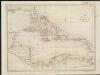
The West Indies
1 : 1
[Střední Amerika]
1 : 1080000 Střední Amerika Schraembl, Franz Anton F.A. Schraembl
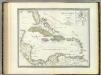
A NEW MAPP of the WEST INDIES, or the ISLANDS of AMERICA in the NORTH SEA; Together with the adjacent DOMINIONS; Explaining what belongs to SPAIN, ENGLAND, FRANCE, HOLLAND &C. As also the severall Tracts made by the Gallions and Flota from place to place,
This interesting map published in 1740 is a later edition of one published by Robert Morden, William Knight and Philip Lea. The colonising powers are indicated in words but colouring is mainly for decoration. Notes give an idea of shipping routes and practices, and in the Gulf of Mexico the number of fathoms in depth are said to be equal to the distance in leagues from the coast! The sketch at bottom left which forms part of the title cartouche shows a group of sailors presenting a pair of shoes to a native in exchange for a chest of gold coins. Morden, Robert. Cartographer.
West Indien
1 : 5500000 Antily (souostroví) Weiland, Karl Ferdinand im Verlage des Geograph. Instituts
[Central-Amerika und Westindien]
Geographischer Atlas über alle Theile der Erde Ziegler, Jakob Melchior Verlag von Dietrich Reimer
The Antilles or West-India Islands.
1 : 8900000 Society for the Diffusion of Useful Knowledge (Great Britain)
Antilles or W. Indies.
1 : 8870400 Letts, Son & Co.
A new and correct general chart of the West Indies including the Gulf of Mexico & Bay of Honduras &c.
1 : 3900000 Heather, W. (William) Heather, W. (William)
[West-Indien mit Florida, d. Landenge v. Panama]
Hand-Atlas über alle Theile der Erde nach dem neuesten Zustande und über das Weltgebäude Stieler, Adolf bei Justus Perthes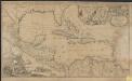
Archipelague du Mexique ou sont les Isles de Cuba, Espagnole, Jamaïque &c.
1 : 5000000 [par Pierre Mortier]
West Indies.
1 : 9500000 Colton, G.W.
West-Indien und Centro-America
Hand-Atlas über alle Theile der Erde nach dem neuesten Zustande und über das Weltgebäude Stieler, Adolf bei Justus Perthes
West Indies.
1 : 17500000 Arrowsmith, Aaron; Lewis, Samuel


