Maps of Africa

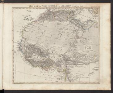
Mittel- und Nord-Africa und Arabien. Westliches Blatt
Stieler's Hand-Atlas Stieler, Adolf bei Justus Perthes
Tabula Moderna Prime Partis Aphricae [Karte], in: Claudii Ptolemei viri Alexandrini mathematice discipline philosophi doctissimi geographie opus [...], S. 263.
1 Karte aus Atlas Waldseemüller, Martin [und Ptolemaeus, Claudius] Übelin, Georg
Noroeste de Africa
1 mapa. Datat al s. XIX. Gras y compañia, editores. Madrid
Africa, including the Mediterranean
1 : 1
Africa Southern Sheet.
1 : 14256000 Colton, G.W.
Barbary and Bildulgerid ; A map of Zaara, Negroe-land, Guinea, &c. (Inset: The Isles of C, Verd)
from A system of geography, or, A new & accurate description of the earth in all its empires, kingdoms and states : illustrated with history and topography, and maps of every country : fairly engraven on copper, according to the latest discoveries and corrections / by Herman Moll.
Mittel- und Nord-Africa, westl. Theil
L'Afrique lacs, fleuves ...
1 : 33000000 Clouet, J. B. L. (Jean-Baptiste Louis), b. 1730
Afrique, septentrionale.
1 : 16000000 Picquet, C.
Africa.
1 : 45000000 Darton, William
Africa Antiqua.
1 : 58000000 Fenner, Rest.
Africæ Antiquæ, et quarundam Europæ, Asiæque adiacentium regionum, accurata delineatio, ad historiarum lucem edita / à Nicolao Blancardo, Batavo, Leidensi, historiarum et politices professore
1 : 15000000 Annotatie: Origineel is Blad 200 in atlas factice; Rechtsonder acht muntafbeeldingen. Cartouche met opdracht aan Iohannes Brunæus Nicolaas Blanckaert 1624-1703 [Amsterdam : Janssonius]
Novissima et perfectissima Africae descriptio
1 : 18000000 1 Karte : Kupferdruck ; 48 x 56 cm Danckerts, Justus [Danckerts]
A draught of the coast of AFRICA from the streights mouth to cape bona Esprance
from The sea-atlas : containing an hydrographical description of most of the sea-coasts of the known parts of the world.
Quarta Affrice Tabula [Karte], in: [Clavdii Ptholomei Cosmographi ...], S. 296.
1 Karte aus Atlas Nicolaus Germanus [und Ptolemaeus, Claudius]
Africæ Antiquæ, et quarundam Europæ, Asiæque adiacentium regionum, accurata delineatio, ad historiarum lucem edita / à Nicolao Blancardo, Batavo, Leidensi, historiarum et politices professore
1 : 15000000 Annotatie: Rechtsonder acht muntafbeeldingen. Cartouche met opdracht aan Iohannes Brunæus Nicolaas Blanckaert 1624-1703 [Amsterdam : Janssonius]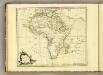
Africa.
1 : 30000000 Jefferys, Thomas
Africa (blank)
1 : 30000000 Jefferys, Thomas
Africae Antique, et quarundam Europae Asiaeque Adiacentium Regionum, accurata delineatio
Blankaart, Nikolaas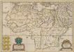
Africae Antiquae. et quarundam. Europae, Asiaeque Adiacentium Regionum. [Karte], in: Novus atlas absolutissimus, Bd. 10, S. 30.
1 Karte aus Atlas Janssonius Offizin
Marocco, Algeria & Tunis. Central Africa.
1 : 4552426 Johnston, W. & A.K.
Africa.
1 : 30096000 Lucas, Fielding Jr.
Carte de la Barbarie de la Nigritie et de la Guinée / par Guill.me Del'Isle de l'Academie Royale des Sciences
1 : 9000000 Annotatie: Afkomstig uit: Atlas nouveau ... / par Guillaume de l'Isle. - Amsterdam : Jean Covens & Corneille Mortier, [na 1757]; Oorspr. afkomstig uit: Atlas de géographie / G. de l'Isle. - Paris : G. de l'Isle, [1700-1712]; Lit.: Norwich's maps of Africa / O. I. Norwich ; Pam Kolbe. - 2nd ed., p. 362, krt. 317; Africa on maps dating from the twelfth to the eighteenth century / E. Klemp, p. 30 en krt. 25; Annotatie geografische gegevens: Met 2 schaalstokken Guillaume Delisle 1675-1726 A Amsterdam : chez Jean Covens et Corneille Mortier
Nord Africa.
1 : 24000000 Reichard, C. G.
Karte von Africa
1 : 8917000
[Mittel- und Nord-Africa und Arabien, Westliches Blatt]
Hand-Atlas über alle Theile der Erde nach dem neuesten Zustande und über das Weltgebäude Stieler, Adolf bei Justus Perthes

Africa.
1 : 39000000 Tanner, Henry S.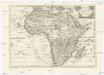
L'Africa
Afrika Sanson, Guillaume De Rossi, Giovanni Giacomo Gio. Giacomo de Rossi