Maps of Africa

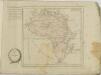
Africa, including the Mediterranean
1 : 1
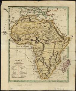
Africa.
1 : 25000000 Gray, Frank Arnold
Afrika's Politische Eintheilung 1900
1 : 15048000 Afrika Kinsky, Carl Kartogr. Anst.
Afrika's Politische Eintheilung 1897
1 : 15048000 Afrika Kinsky, Carl Kartogr. Anst.
Afrika's Politische Eintheilung 1897
1 : 15048000 Afrika Kinsky, Carl Kartogr. Anst.
Political divisions of Africa 1897
1 : 15048000 Afrika Kinsky, Carl Cartograph. office
Carte politique de l'Afrique 1897
1 : 15048000 Afrika Kinsky, Carl Institut cartographique
Africa Southern Sheet.
1 : 14256000 Colton, G.W.
Africa - Physical. Pergamon World Atlas.
1 : 30000000 Polish Army Topography Service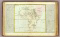
L'Afrique lacs, fleuves ...
1 : 33000000 Clouet, J. B. L. (Jean-Baptiste Louis), b. 1730
Africa.
1 : 45000000 Darton, William
Afrika.
1 : 30000000 Berghaus, Hermann
Africa
1 : 30096000 Afrika
Afrika
1 : 26666666 Afrika Maschek, Rud. Artaria
Eisenbahn- und Wege-Karte von Afrika
1 : 30000000 Afrika A. Hartleben's Verlag
Africa
1 : 30000000 Afrika Gräf, Adolph Luther, Th. Geographisches Institut
Africa (political).
1 : 28990200 Fisher, Richard Swainson
158-159. Africa, Political. The World Atlas.
1 : 20000000 USSR (Union of Soviet Socialist Republics).
107-08. Africa politica.
1 : 20000000 Touring club italiano
105-06. Africa fisica.
1 : 20000000 Touring club italiano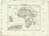
Afrika
1 : 30000000 Afrika Merklas, Václav W. Merklas
Afrika
1 : 30000000 Afrika Merklas, Václav W. Merklas
Novissima et perfectissima Africae descriptio
1 : 18000000 1 Karte : Kupferdruck ; 48 x 56 cm Danckerts, Justus [Danckerts]
Afrique physique
Vidal de La Blache, Paul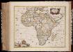
Africæ accurata tabula / ex officina Nic. Visscher
1 : 16000000 Annotatie: Met opdracht aan Gerard Schaep door N. Visscher; Kaart uitg. in de periode ca. 1680-ca. 1690; Origineel is Blad 201 in atlas factice Nicolaes Jansz. Visscher jr. 1649-1702 [Amsterdam : N. Visscher]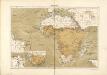
Atlas für Industrie- und Handelsgeographie: Für commercielle und technische Lehranstalten, für Kaufleute und Industrielle

[3][3]Totius Africae accuratissima tabula, uit: Atlas sive Descriptio terrarum orbis
Annotatie: Gedigitaliseerde versie. Amsterdam. Heiloo : Picturae (vervaardiger), 2015. tiff-bestand. Gedigitaliseerd: 07-01-2015; Origineel: Universiteitsbibliotheek Vrije Universiteit (XL.05127.-) ; Netherlands; Titelpagina ontbreekt Wit, Frederik de Amsterdam : Frederick de Wit
Afrika
1 : 30000000 Kiepert, Richard Dietrich Reimer