Maps of Upper Palatinate
Militair Karte von Süd-Deutschland in 20 Sectionen
1 : 400000 7. Section Coulon, Alois von A. von Coulon
Provincia Pilsnensis
1 : 217000 Mollova mapová sbírka Erber, Bernardinus Winkler, Johann Christoph Kurzböck, Josef von
Regni Bohemiae Circulus Pilsnensis
1 : 225800 Mollova mapová sbírka Homann, Johann Baptista - dědici
Das Fürstenthum Sulzbach und die Landgrafschaft Leuchtenberg
1 Karte : Kupferdruck ; 19 x 28 cm Reilly F. J. J. von Reilly
Das Königreich Bayern disseits des Rheins
Grosser Hand-Atlas über alle Theile der Erde in 170 Karten Meyer, J. Verlag des Bibliographischen Instituts
Carte topographique d'Allemagne contenant le Haut Palatinat, une partie du royaume de Boheme, de la Basse Baviere
1 Karte : Kupferdruck ; 46 x 61 cm Jaeger; Facius I. W. A. Iaeger ches qui cette carte se vend
Bavariae Palatinatus vulgo Die Ober-Pfaltz in Subjacentes ejusdem Praefecturas aceuratissime divisus
1 : 300000 Mollova mapová sbírka Visscher, Nicolaes Schenk, Peter II
Palatinatus Bavariae vulgo Die Obere Pfaltz in omnes ejusdem Status et Praefecturas accuratà divisus
1 : 310000 Mollova mapová sbírka Homann, Johann Baptist Homann, Johann Baptista
Generalkarte von Zentraleuropa

Palatinat. Superior sive Bavariae, Germanice Die Obere Pfaltz
1 : 310000 Mollova mapová sbírka Seutter, Matthäus Seutter, Matthäus

Bavariæ palatinatus vulgo die Ober-Pfaltz
1 Karte : Kupferdruck ; 47 x 55 cm Visscher Nicolaes Visscher
Bayern II.
1 : 650000 Radefeld, Carl Christian Franz, 1788-1874
Palatinat. superior sive Bavariæ germanice Die Obere Pfaltz secundum omnes status et præfecturas accurata designatione
1 Karte : Kupferdruck ; 47 x 55 cm Seutter; Probst anjezo in Verlag bey Ioh. Michael Probst chalc
Geographische Mauth-Charte von dem Herzogthum der Ober-Pfalz und der Landgrafschaft Leuchtenberg
Horní Falc (Německo)
Palatinat superior sive Bavariae, Germanice die Obere Pfaltz
1 : 300000 Bavorsko (Německo) Seutter, Matthäus per Matthaeum Seutter
Sacri Imperii Romani Circuli et Electoratus Bavariae cum Finitimis Geographica Descriptio. Cum Privilegio D.D. Ordinum Generalium ut et Hollandiae West Frisiaequae]
1 : 270000 Mollova mapová sbírka Valck, Leonardus
Palatinatus Bavariae vulgo die Obere Pfaltz in omnes ejusdem status et praefecturas accurate divisis
1 : 310000 Bavorsko (Německo) Homann, Johann Baptist Ioh. Baptista Homanno
Palatinatus Bavariae vulgo die Obere Pfaltz in omnes ejusdem status et praefecturas accurate divisus
1 : 310000 Bavorsko (Německo) Homann, Johann Baptist Johann Baptist Homann
Palatinatus Bavariae vulgo die Obere Pfaltz in omnes ejusdem status et praefecturas accurate divisus
1 : 310000 Bavorsko (Německo) Homann, Johann Baptist Johann Baptist Homann
Palatinatus Bavariae vulgo die Obere Pfaltz in omnes ejusdem status et praefecturas accurate divisus
1 : 310000 Bavorsko (Německo) Homann, Johann Baptist Johann Baptist Homann
Palatinatus Bavariae vulgo die Obere Pfaltz in omnes ejusdem status et praefecturas accurate divisus
1 : 310000 Bavorsko (Německo) Homann, Johann Baptist Johann Baptist Homann
Sacri imperii Romani circuli et electoratus Bavariæ, 2
1 Karte : mehrfarbig ; R. et J. Ottens
Regni Bohemiae, Circulus Pilsnensis ex Müllerianis aliisque recentissimis subsidiis choro
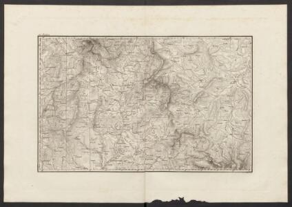
Přehledná mapa Plzeňského kraje vydaná Homanovými dědici, zpracovaná podle Müllerovy mapy Čech. Mapa zachycuje sídelní a vodní síť, terén a lesy naznačeny kopečky a stromky. V sousedním území zaznamenána významnější místa. Označena sídla významnější šlechty (hr. v. Sinzendorf v Plané, premonstráti v Teplé, benediktýni v Kladrubech, Löwenstein v Bezdružicích). V pravém horním rohu v rámečku z úponků vinné révy měřítko označené jako 'Scalla milliarium'. V pravém dolním rohu v rokajovém rámci názvové údaje. V levém dolním rohu v rokajovém rámci latinské vysvětlivky značek 'Signorum Explicati'.
Československo v mapách

Strecke
Cheb (Česko) K. k. Österreichische Staatsbahnen
Deutsche Strassenprofilkarte für Radfahrer
Furth im Wald (Německo) Mittelbach's Verlag