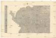
Maps of Upper Palatinate

Bayern II.
1 : 650000 Radefeld, Carl Christian Franz, 1788-1874
Das Königreich Bayern disseits des Rheins
Grosser Hand-Atlas über alle Theile der Erde in 170 Karten Meyer, J. Verlag des Bibliographischen Instituts
Sbírka map a diagramů použitých na mírových konferencích v Paříži v letech 1919 - 1920

Eisenbahnkarte der k.u.k. oesterreichisch-ungarischen Monarchie

Mapa správního rozdělení ČSR: Západočeský kraj

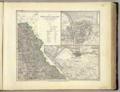
Sacri imperii Romani circuli et electoratus Bavariæ, 2
1 Karte : mehrfarbig ; R. et J. Ottens
Sacri Imperii Romani Circuli et Electoratus Bavariae cum Finitimis Geographica Descriptio. Cum Privilegio D.D. Ordinum Generalium ut et Hollandiae West Frisiaequae]
1 : 270000 Mollova mapová sbírka Valck, Leonardus
Militair Karte von Süd-Deutschland in 20 Sectionen
1 : 400000 7. Section Coulon, Alois von A. von Coulon
Neubertova generální automapa Republiky československé
1 : 200000 Cheb (Česko : oblast) Soukup, Jan V. Neubert a synové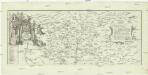
Geographische Mauth-Charte von dem Herzogthum der Ober-Pfalz und der Landgrafschaft Leuchtenberg
Horní Falc (Německo)
Carte topographique d'Allemagne contenant le Haut Palatinat, une partie du royaume de Boheme, de la Basse Baviere
1 Karte : Kupferdruck ; 46 x 61 cm Jaeger; Facius I. W. A. Iaeger ches qui cette carte se vend
Carte chorographique de la Boheme...

Regni Bohemiae, Circulus Pilsnensis ex Müllerianis aliisque recentissimis subsidiis choro
Přehledná mapa Plzeňského kraje vydaná Homanovými dědici, zpracovaná podle Müllerovy mapy Čech. Mapa zachycuje sídelní a vodní síť, terén a lesy naznačeny kopečky a stromky. V sousedním území zaznamenána významnější místa. Označena sídla významnější šlechty (hr. v. Sinzendorf v Plané, premonstráti v Teplé, benediktýni v Kladrubech, Löwenstein v Bezdružicích). V pravém horním rohu v rámečku z úponků vinné révy měřítko označené jako 'Scalla milliarium'. V pravém dolním rohu v rokajovém rámci názvové údaje. V levém dolním rohu v rokajovém rámci latinské vysvětlivky značek 'Signorum Explicati'.
Strecke
Cheb (Česko) K. k. Österreichische Staatsbahnen
Palatinat. Superior sive Bavariae, Germanice Die Obere Pfaltz
1 : 310000 Mollova mapová sbírka Seutter, Matthäus Seutter, Matthäus
Special-Karte des Egerer Kreis, resp. politischen Verwaltungsbezirkes Königreiche Böhmen
1 : 224000 Cheb-oblast (Česko) Schmidt, Eduard Wendelin Morauer
Special-Karte des Egerer Kreis, resp. politischen Verwaltungsbezirkes Königreiche Böhmen
1 : 224000 Cheb-oblast (Česko) Schmidt, Eduard Steyrer, Fr. C. Wendelin Morauer
Special-Karte des Egerer Kreis, resp. politischen Verwaltungsbezirkes Königreiche Böhmen
1 : 224000 Cheb-oblast (Česko) Schmidt, Eduard Wendelin Morauer
Deutsche Strassenprofilkarte für Radfahrer
Furth im Wald (Německo) Mittelbach's Verlag
Taus 116, uit: Special-Karte von Mittel-Europa / nach amtlichen Quellen bearbeitet von W. Liebenow
1 : 300000 titelvariant: W. Liebenow's Mittel-Europa; Annotatie: Titel boven de bladen: W. Liebenow's Mittel-Europa Johannes Wilhelm Liebenow 1822-1897 Frankfurt a. M. : Ludwig Ravenstein
Normální mezinárodní letecká mapa.

Generální mapa ČSR

Spezial Karte für Verkehr, landwirthschaftliche, Montan u. gewerbliche Jndustrie des Bezirkes der Handels und gewerbekammer Eger
1 : 150000 Cheb-oblast (Česko) Daniel, W. R. Lechner's k. k. Hof u. Universitäts-Buchhandlung
Západočeské lázně

Sacri Romani imperii circuli et electoratus Bavariae tabula, 2
4 Blätter : s.n.
Provincia Pilsnensis
Plzeň-oblast (Česko) Bernardi, Augustin Augustin Bernardi
Provincia Pilsnensis
Plzeň-oblast (Česko) Winkler, Johann Christoph
Provincia Pilsnensis
Plzeňský kraj (Česko) Müller, Johann Christoph
Provincia Pilsnensis
Plzeň-oblast (Česko) Müller, Johann Christoph JC. Winkler