Maps of Libeň

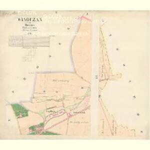
Wisoczan - c8937-1-004 - Kaiserpflichtexemplar der Landkarten des stabilen Katasters
1 : 2880
Wisoczan - c8937-1-001 - Kaiserpflichtexemplar der Landkarten des stabilen Katasters
1 : 2880
Wisoczan - c8937-1-002 - Kaiserpflichtexemplar der Landkarten des stabilen Katasters
1 : 2880
Wisoczan - c8937-1-003 - Kaiserpflichtexemplar der Landkarten des stabilen Katasters
1 : 2880
Auto-Praha : automobilní plán Velké Prahy a příručka pro automobilisty
1 : 50000
Orientační plán hlavního města Prahy s okolím

Orientační plán hlavního města Prahy s okolím

Orientační plán hlavního města Prahy s okolím
1 : 5000
Orientační plán král. Hl. města Prahy

Prosek - c6119-1-001 - Kaiserpflichtexemplar der Landkarten des stabilen Katasters
1 : 2880
Orientační plán král. Hl. města Prahy

Orientační plán Prahy a obcí sousedních List 13.
1 : 5000
Plan der Gegend vor dem Porziczerthore zum Gebrauche bei der Beurtheilung der Distanzen
Bubeneč (Praha, Česko) Wacha, V.
Plán Líbně a Vysočan se sousedními obcemi
Plán VIII. části Prahy Libně a obcí sousedních
1 : 15000
Lieben - c3990-1-004 - Kaiserpflichtexemplar der Landkarten des stabilen Katasters
1 : 2880
Lieben - c3990-1-003 - Kaiserpflichtexemplar der Landkarten des stabilen Katasters
1 : 2880
Lieben - c3990-1-001 - Kaiserpflichtexemplar der Landkarten des stabilen Katasters
1 : 2880
Lieben - c3990-1-002 - Kaiserpflichtexemplar der Landkarten des stabilen Katasters
1 : 2880
[Palmovka a Libeň]
Libeň (Praha, Česko) Vilím, Jan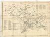
[Palmovka a Libeň]
Libeň (Praha, Česko) Vilím, Jan
Hlaupetin - c1883-1-001 - Kaiserpflichtexemplar der Landkarten des stabilen Katasters
1 : 2880
Hlaupetin - c1883-1-004 - Kaiserpflichtexemplar der Landkarten des stabilen Katasters
1 : 2880
Hlaupetin - c1883-1-003 - Kaiserpflichtexemplar der Landkarten des stabilen Katasters
1 : 2880
Hlaupetin - c1883-1-002 - Kaiserpflichtexemplar der Landkarten des stabilen Katasters
1 : 2880
Hlaupetin - c1883-1-005 - Kaiserpflichtexemplar der Landkarten des stabilen Katasters
1 : 2880
Orientační plán Prahy a obcí sousedních List 13a.
1 : 5000
Hrdlorzes - c2347-1-003 - Kaiserpflichtexemplar der Landkarten des stabilen Katasters
1 : 2880
Hrdlorzes - c2347-1-002 - Kaiserpflichtexemplar der Landkarten des stabilen Katasters
1 : 2880