Maps of Tišice

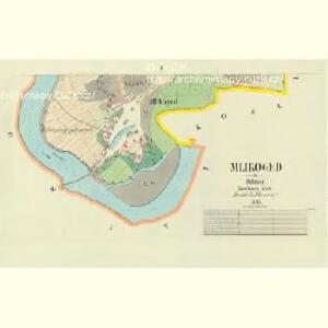
Mlikoged - c4757-1-002 - Kaiserpflichtexemplar der Landkarten des stabilen Katasters
1 : 2880
Mlikoged - c4757-1-001 - Kaiserpflichtexemplar der Landkarten des stabilen Katasters
1 : 2880
Lobkowitz - c4187-1-002 - Kaiserpflichtexemplar der Landkarten des stabilen Katasters
1 : 2880
Lobkowitz - c4187-1-003 - Kaiserpflichtexemplar der Landkarten des stabilen Katasters
1 : 2880
Lobkowitz - c4187-1-001 - Kaiserpflichtexemplar der Landkarten des stabilen Katasters
1 : 2880
Lobkowitz - c4187-1-004 - Kaiserpflichtexemplar der Landkarten des stabilen Katasters
1 : 2880
Tischitz - c7923-1-002 - Kaiserpflichtexemplar der Landkarten des stabilen Katasters
1 : 2880
Tischitz - c7923-1-003 - Kaiserpflichtexemplar der Landkarten des stabilen Katasters
1 : 2880
Tischitz - c7923-1-001 - Kaiserpflichtexemplar der Landkarten des stabilen Katasters
1 : 2880
Kozell - c3458-1-003 - Kaiserpflichtexemplar der Landkarten des stabilen Katasters
1 : 2880
Kozell - c3458-1-004 - Kaiserpflichtexemplar der Landkarten des stabilen Katasters
1 : 2880
Kozell - c3458-1-002 - Kaiserpflichtexemplar der Landkarten des stabilen Katasters
1 : 2880
Kozell - c3458-1-001 - Kaiserpflichtexemplar der Landkarten des stabilen Katasters
1 : 2880
Chrast - c2626-1-001 - Kaiserpflichtexemplar der Landkarten des stabilen Katasters
1 : 2880
Chrast - c2626-1-002 - Kaiserpflichtexemplar der Landkarten des stabilen Katasters
1 : 2880
Mapa politického a školního okresu Karlínského
III. vojenské mapování 3853/3
1 : 25000
Gradkartenblatt
1 : 25000 Mělník-oblast (Česko) Albrecht, Julius
Plan der südlichen Gegend von Melnik
1 : 48000 Mělník-oblast (Česko) Schwihlik, Fr.
III. vojenské mapování 3853/3
1 : 25000
III. vojenské mapování 3853/3
1 : 25000
Plan der Gegend zwischen Kletzan und Weltrus
1 : 47500 Klecany (Česko) Schwihlik, F.
Plan der Gegend zwischen Kletzan und Weltrus
1 : 48000 Klecany (Česko) Adam
Karte des Brandeiser Bezirkes im Prager Kreise
1 : 70000 Brandýs nad Labem-Stará Boleslav-oblast (Česko) Wagner, Jan Eduard Karl André
Podrobné mapy zemí Koruny české v měřítku 1:75.000 a mapa vzdáleností všech míst při silnici ležících
1 : 75000 Kostelec nad Labem (Česko : oblast) Bělohlav, Josef Kučera, Karel F. Topič
Podrobné mapy zemí Koruny české v měřítku 1:75.000 a mapa vzdáleností všech míst při silnici ležících - Mělník - Kostelec n. L. Průvodce statisticko-historický po všech místech na těchto mapách uvedených a rejstřík věcný názvů hor, potoků, řek, rybníků atd. Sešit 7. List 54,
1 : 75000
Mapa okresu Mělnického
1 : 58000 Mělník-oblast (Česko) Opa, František Karel František Kar. Opa
Karte des Melniker Bezirkes im Prager Kreise
1 : 72000 Mělník-oblast (Česko) Wagner, Jan Eduard in Commission bei Karl André
Karte des Melniker Bezirkes im Prager Kreise
1 : 72000 Mělník-oblast (Česko) Wagner, Jan Eduard in Commission bei Karl André